Forsyth County, North Carolina
| Forsyth County, North Carolina | |||
|---|---|---|---|
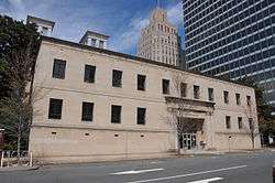 Forsyth County Courthouse in Winston-Salem. | |||
| |||
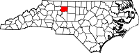 Location in the U.S. state of North Carolina | |||
 North Carolina's location in the U.S. | |||
| Founded | January 16, 1849 | ||
| Named for | Colonel Benjamin Forsyth | ||
| Seat | Winston-Salem | ||
| Largest city | Winston-Salem | ||
| Area | |||
| • Total | 413 sq mi (1,070 km2) | ||
| • Land | 408 sq mi (1,057 km2) | ||
| • Water | 4.5 sq mi (12 km2), 1.1% | ||
| Population (est.) | |||
| • (2014) | 365,298 | ||
| • Density | 895.4/sq mi (345.7/km2) | ||
| Congressional district | 5th | ||
| Time zone | Eastern: UTC−5/−4 | ||
| Website |
www | ||


Forsyth County is a county located in the U.S. state of North Carolina. As of the 2010 census, the population was 350,670,[1] making it the fourth-most populous county in North Carolina. Its county seat is Winston-Salem.[2]
Forsyth County is included in the Winston-Salem, NC Metropolitan Statistical Area, which is also included in the Greensboro-Winston-Salem-High Point, NC Combined Statistical Area.
Parts of Forsyth County are in the Yadkin Valley wine region.
History
The county was formed in 1849 from Stokes County. It was named for Colonel Benjamin Forsyth, who was killed in the War of 1812.[3]
Geography
According to the U.S. Census Bureau, the county is in the outer appalachian mountains, and has a total area of 413 square miles (1,070 km2), of which 408 square miles (1,060 km2) is land and 4.5 square miles (12 km2) (1.1%) is water.[4]
Major highways
Demographics
| Historical population | |||
|---|---|---|---|
| Census | Pop. | %± | |
| 1850 | 11,168 | — | |
| 1860 | 12,692 | 13.6% | |
| 1870 | 13,050 | 2.8% | |
| 1880 | 18,070 | 38.5% | |
| 1890 | 28,434 | 57.4% | |
| 1900 | 35,261 | 24.0% | |
| 1910 | 47,311 | 34.2% | |
| 1920 | 77,269 | 63.3% | |
| 1930 | 111,681 | 44.5% | |
| 1940 | 126,475 | 13.2% | |
| 1950 | 146,135 | 15.5% | |
| 1960 | 189,428 | 29.6% | |
| 1970 | 214,348 | 13.2% | |
| 1980 | 243,683 | 13.7% | |
| 1990 | 265,878 | 9.1% | |
| 2000 | 306,067 | 15.1% | |
| 2010 | 350,670 | 14.6% | |
| Est. 2016 | 371,511 | [5] | 5.9% |
| U.S. Decennial Census[6] 1790-1960[7] 1900-1990[8] 1990-2000[9] 2010-2013[1] | |||
As of the census[10] of 2000, there were 306,067 people, 123,851 households, and 81,741 families residing in the county. The population density was 747 people per square mile (289/km²). There were 133,093 housing units at an average density of 325 per square mile (125/km²). The racial makeup of the county was 68.47% White, 25.61% Black or African American, 0.30% Native American, 1.04% Asian, 0.03% Pacific Islander, 3.25% from other races, and 1.30% from two or more races. 6.40% of the population were Hispanic or Latino of any race.
There were 123,851 households out of which 30.50% had children under the age of 18 living with them, 48.90% were married couples living together, 13.50% had a female householder with no husband present, and 34.00% were non-families. 28.90% of all households were made up of individuals and 9.30% had someone living alone who was 65 years of age or older. The average household size was 2.39 and the average family size was 2.94.
In the county, the population was spread out with 23.90% under the age of 18, 9.60% from 18 to 24, 31.10% from 25 to 44, 22.80% from 45 to 64, and 12.60% who were 65 years of age or older. The median age was 36 years. For every 100 females there were 91.50 males. For every 100 females age 18 and over, there were 87.40 males.
The median income for a household in the county was $42,097, and the median income for a family was $52,032. Males had a median income of $36,158 versus $27,319 for females. The per capita income for the county was $23,023. About 7.90% of families and 11.00% of the population were below the poverty line, including 15.10% of those under age 18 and 9.70% of those age 65 or over.
Communities
Cities
- High Point (mostly in Guilford County, also in Randolph County, Davidson County)
- Winston-Salem (county seat)
Towns
- Bethania
- Kernersville (partially in Guilford County)
- King (mostly in Stokes County)
- Lewisville
- Rural Hall
- Walkertown
Villages
- Clemmons
- Tobaccoville (also in Stokes County)
Census-designated place
Townships
Former township
- Middle Fork Township was split into Middle Fork I Township and Middle Fork II Township in 2003.[11]
Unincorporated communities
Law and government
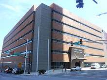
The Forsyth County Government Center is located at 201 North Chestnut Street in Downtown Winston-Salem. Forsyth County is a member of the regional Northwest Piedmont Council of Governments.
The Forsyth County Public Library, founded in 1906, is free for residents of Forsyth and surrounding counties, while all others must pay a small yearly fee for a library card. The library runs Adult, Children's, and Hispanic Outreach programs. Its main "Central Library" is in downtown Winston-Salem, with locations all across the county.[12]
Politics
Like most major urban counties, Forsyth has seen a trend towards the Democratic Party in recent elections after having voted Republican at every election between 1980 and 2004.
| Year | Republican | Democratic | Third parties |
|---|---|---|---|
| 2016 | 42.6% 75,975 | 53.0% 94,464 | 4.4% 7,873 |
| 2012 | 45.8% 79,768 | 53.0% 92,323 | 1.1% 1,978 |
| 2008 | 44.4% 73,674 | 54.8% 91,085 | 0.8% 1,374 |
| 2004 | 54.1% 75,294 | 45.5% 63,340 | 0.4% 491 |
| 2000 | 56.0% 67,700 | 43.4% 52,457 | 0.7% 785 |
| 1996 | 52.8% 59,160 | 41.5% 46,543 | 5.7% 6,330 |
| 1992 | 45.4% 52,787 | 42.2% 49,006 | 12.5% 14,481 |
| 1988 | 59.0% 57,688 | 40.7% 39,726 | 0.3% 321 |
| 1984 | 61.5% 59,208 | 38.3% 36,814 | 0.2% 189 |
| 1980 | 50.0% 42,389 | 45.8% 38,870 | 4.2% 3,539 |
| 1976 | 49.3% 38,886 | 50.2% 39,561 | 0.5% 361 |
| 1972 | 67.7% 46,415 | 30.5% 20,928 | 1.8% 1,226 |
| 1968 | 46.8% 31,623 | 30.0% 20,281 | 23.2% 15,681 |
| 1964 | 48.9% 30,276 | 51.1% 31,615 | |
| 1960 | 58.1% 33,374 | 41.9% 24,035 | |
| 1956 | 65.0% 29,368 | 35.0% 15,819 | |
| 1952 | 51.9% 26,436 | 48.1% 24,535 | |
| 1948 | 41.0% 10,147 | 49.4% 12,201 | 9.6% 2,377 |
| 1944 | 37.9% 10,014 | 62.1% 16,390 | |
| 1940 | 25.6% 7,125 | 74.4% 20,664 | |
| 1936 | 21.9% 5,256 | 78.1% 18,734 | |
| 1932 | 28.5% 5,727 | 69.7% 14,016 | 1.8% 357 |
| 1928 | 66.6% 13,258 | 33.4% 6,639 | |
| 1924 | 40.3% 5,315 | 56.2% 7,404 | 3.5% 459 |
| 1920 | 45.5% 6,792 | 54.5% 8,123 | |
| 1916 | 45.2% 3,585 | 51.8% 4,115 | 3.0% 238 |
| 1912 | 26.7% 1,689 | 48.1% 3,042 | 25.2% 1,591 |
See also
- Adelaide Fries, author of the 1898 Forsyth County
- Arts Council of Winston-Salem Forsyth County
- National Register of Historic Places listings in Forsyth County, North Carolina
- Winston-Salem/Forsyth County Schools School district
References
- 1 2 "State & County QuickFacts". United States Census Bureau. Archived from the original on July 10, 2011. Retrieved October 19, 2013.
- ↑ "Find a County". National Association of Counties. Archived from the original on 2011-05-31. Retrieved 2011-06-07.
- ↑ Gannett, Henry (1905). The Origin of Certain Place Names in the United States. Govt. Print. Off. p. 128.
- ↑ "2010 Census Gazetteer Files". United States Census Bureau. August 22, 2012. Archived from the original on January 12, 2015. Retrieved January 14, 2015.
- ↑ "Population and Housing Unit Estimates". Retrieved June 9, 2017.
- ↑ "U.S. Decennial Census". United States Census Bureau. Archived from the original on May 12, 2015. Retrieved January 14, 2015.
- ↑ "Historical Census Browser". University of Virginia Library. Retrieved January 14, 2015.
- ↑ Forstall, Richard L., ed. (March 27, 1995). "Population of Counties by Decennial Census: 1900 to 1990". United States Census Bureau. Retrieved January 14, 2015.
- ↑ "Census 2000 PHC-T-4. Ranking Tables for Counties: 1990 and 2000" (PDF). United States Census Bureau. April 2, 2001. Retrieved January 14, 2015.
- ↑ "American FactFinder". United States Census Bureau. Archived from the original on 2013-09-11. Retrieved 2008-01-31.
- ↑ "Middle Fork Township". Geographic Names Information System. United States Geological Survey.
- ↑ "Locations". Forsyth County Public Library website. Forsyth County. Retrieved June 6, 2012.
- ↑ Leip, David. "Dave Leip's Atlas of U.S. Presidential Elections". uselectionatlas.org. Retrieved 2018-03-15.
External links
| Wikimedia Commons has media related to Forsyth County, North Carolina. |
- Digital Forsyth, a collaborative digitization project of historic images
- Forsyth County government official website
- NCGenWeb Forsyth County - free genealogy resources for the county
Places adjacent to Forsyth County, North Carolina | ||||||||||
|---|---|---|---|---|---|---|---|---|---|---|
| ||||||||||
Municipalities and communities of Forsyth County, North Carolina, United States | ||
|---|---|---|
| Cities | 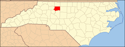 | |
| Towns | ||
| Villages | ||
| Townships | ||
| CDP | ||
| Unincorporated communities | ||
| Footnotes | ‡This populated place also has portions in an adjacent county or counties | |
