Bertie County, North Carolina
| Bertie County, North Carolina | |
|---|---|
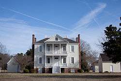 Manor House of Hope Plantation near Windsor. | |
 Location in the U.S. state of North Carolina | |
 North Carolina's location in the U.S. | |
| Founded | 1739 |
| Named for | James and/or Henry Bertie |
| Seat | Windsor |
| Largest town | Windsor |
| Area | |
| • Total | 741 sq mi (1,919 km2) |
| • Land | 699 sq mi (1,810 km2) |
| • Water | 42 sq mi (109 km2), 5.7% |
| Population | |
| • (2015) | 20,199 |
| • Density | 30/sq mi (10/km2) |
| Congressional district | 1st |
| Time zone | Eastern: UTC−5/−4 |
| Website |
www |
Bertie County is a county located in the northeast area of the U.S. state of North Carolina. As of the 2015 census, the population was 20,199.[1] Its county seat is Windsor.[2] The county was created in 1722 as Bertie Precinct and gained county status in 1739.[3]
The Sans Souci Ferry, providing access across the Cashie River is the county's only ferry.
History
The county was formed as Bertie Precinct in 1722 from the part of Chowan Precinct of Albemarle County lying west of the Chowan River. It was named for James Bertie, his brother Henry Bertie, or perhaps both, each having been one of the Lords Proprietors of Carolina.
In 1729 parts of Bertie Precinct, Chowan Precinct, Currituck Precinct, and Pasquotank Precinct of Albemarle County were combined to form Tyrrell Precinct. With the abolition of Albemarle County in 1739, all of its constituent precincts became separate counties. As population of settlers increased, in 1741 parts of Bertie County were organized as Edgecombe County and Northampton County. Finally, in 1759 parts of Bertie, Chowan, and Northampton counties were combined to form Hertford County. Bertie's boundaries have remained the same since then.
This mostly rural county depended on the agricultural economy well into the 20th century. In the colonial and antebellum eras, tobacco and cotton were the chief commodity crops, worked by enslaved African Americans. After the Civil War, agriculture continued to be important to the county. In the 21st century, developers have referred to it as being within the Inner Banks region, which is increasingly attracting retirees and buyers of second homes, because of its beaches and lovely landscapes.
Geography
According to the U.S. Census Bureau, the county has a total area of 741 square miles (1,920 km2), of which 699 square miles (1,810 km2) is land and 42 square miles (110 km2) (5.7%) is water.[4]
Adjacent Counties
- Hertford County, North Carolina - north
- Chowan County, North Carolina - east
- Washington County, North Carolina - southeast
- Martin County, North Carolina - south
- Halifax County, North Carolina - west
- Northampton County, North Carolina - northwest
National protected area
Major highways
Demographics
| Historical population | |||
|---|---|---|---|
| Census | Pop. | %± | |
| 1790 | 12,462 | — | |
| 1800 | 11,249 | −9.7% | |
| 1810 | 11,218 | −0.3% | |
| 1820 | 10,805 | −3.7% | |
| 1830 | 12,262 | 13.5% | |
| 1840 | 12,175 | −0.7% | |
| 1850 | 12,851 | 5.6% | |
| 1860 | 14,310 | 11.4% | |
| 1870 | 12,950 | −9.5% | |
| 1880 | 16,399 | 26.6% | |
| 1890 | 19,176 | 16.9% | |
| 1900 | 20,538 | 7.1% | |
| 1910 | 23,039 | 12.2% | |
| 1920 | 23,993 | 4.1% | |
| 1930 | 25,844 | 7.7% | |
| 1940 | 26,201 | 1.4% | |
| 1950 | 26,439 | 0.9% | |
| 1960 | 24,350 | −7.9% | |
| 1970 | 20,528 | −15.7% | |
| 1980 | 21,024 | 2.4% | |
| 1990 | 20,388 | −3.0% | |
| 2000 | 19,773 | −3.0% | |
| 2010 | 21,282 | 7.6% | |
| Est. 2016 | 19,854 | [5] | −6.7% |
| U.S. Decennial Census[6] 1790-1960[7] 1900-1990[8] 1990-2000[9] 2010-2013[1] | |||
As of the 2010 United States Census, there were 21,282 people residing in the county. 62.5% were Black or African American, 35.2% White, 0.5% Asian, 0.5% Native American, 0.5% of some other race and 0.9% of two or more races. 1.3% were Hispanic or Latino (of any race).
As of the census[10] of 2000, there were 19,773 people, 7,743 households, and 5,427 families residing in the county. The population density was 28 people per square mile (11/km²). There were 9,050 housing units at an average density of 13 per square mile (5/km²). The racial makeup of the county was 62.34% Black or African American, 36.30% White, 0.44% Native American, 0.11% Asian, 0.01% Pacific Islander, 0.33% from other races, 0.48% from two or more races. 0.99% of the population were Hispanic or Latino of any race.
There were 7,743 households out of which 29.70% had children under the age of 18 living with them, 46.00% were married couples living together, 20.10% had a female householder with no husband present, and 29.90% were non-families. 27.00% of all households were made up of individuals and 13.10% had someone living alone who was 65 years of age or older. The average household size was 2.53 and the average family size was 3.07.
In the county, the population was spread out with 26.10% under the age of 18, 7.70% from 18 to 24, 26.40% from 25 to 44, 23.80% from 45 to 64, and 16.00% who were 65 years of age or older. The median age was 39 years. For every 100 females there were 87.60 males. For every 100 females age 18 and over, there were 82.00 males.
The median income for a household in the county was $25,177, and the median income for a family was $30,186. Males had a median income of $26,866 versus $18,318 for females. The per capita income for the county was $14,096. About 19.30% of families and 26% of the population were below the poverty line, including 30.70% of those under age 18 and 28.30% of those age 65 or over.
Law and government
Bertie County is a member of the Mid-East Commission regional council of governments. The County Sheriff is the chief law enforcement officer.
| Year | Republican | Democratic | Third parties |
|---|---|---|---|
| 2016 | 37.0% 3,456 | 61.8% 5,778 | 1.2% 113 |
| 2012 | 33.5% 3,387 | 66.1% 6,695 | 0.4% 41 |
| 2008 | 34.6% 3,376 | 65.2% 6,365 | 0.2% 22 |
| 2004 | 38.1% 3,057 | 61.5% 4,938 | 0.5% 37 |
| 2000 | 34.7% 2,488 | 64.9% 4,660 | 0.4% 28 |
| 1996 | 27.8% 1,745 | 67.0% 4,202 | 5.2% 324 |
| 1992 | 26.0% 1,756 | 65.0% 4,382 | 9.0% 605 |
| 1988 | 36.2% 2,145 | 63.6% 3,762 | 0.2% 12 |
| 1984 | 41.9% 2,879 | 57.5% 3,953 | 0.6% 38 |
| 1980 | 30.1% 1,695 | 68.6% 3,863 | 1.3% 74 |
| 1976 | 24.4% 1,332 | 75.3% 4,117 | 0.4% 21 |
| 1972 | 60.5% 2,874 | 38.3% 1,819 | 1.1% 54 |
| 1968 | 11.4% 811 | 45.0% 3,207 | 43.6% 3,108 |
| 1964 | 21.8% 931 | 78.2% 3,332 | |
| 1960 | 13.6% 577 | 86.5% 3,682 | |
| 1956 | 12.2% 469 | 87.8% 3,373 | |
| 1952 | 9.7% 384 | 90.3% 3,557 | |
| 1948 | 2.7% 85 | 95.7% 3,034 | 1.6% 51 |
| 1944 | 3.8% 124 | 96.2% 3,142 | |
| 1940 | 2.9% 98 | 97.1% 3,287 | |
| 1936 | 2.9% 115 | 97.1% 3,828 | |
| 1932 | 2.0% 65 | 97.8% 3,154 | 0.2% 5 |
| 1928 | 15.8% 374 | 84.3% 2,000 | |
| 1924 | 8.2% 159 | 91.6% 1,785 | 0.3% 5 |
| 1920 | 10.3% 212 | 89.7% 1,840 | |
| 1916 | 7.4% 116 | 92.6% 1,461 | |
| 1912 | 2.6% 43 | 93.8% 1,571 | 3.6% 61 |
Education
- Bertie High School
- Lawrence Academy
- Bethel Christian Academy
Communities
Towns
- Askewville
- Aulander
- Colerain
- Kelford
- Lewiston Woodville
- Powellsville
- Roxobel
- Windsor (county seat)
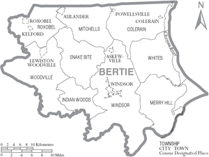
Townships
- Colerain
- Indian Woods
- Merry Hill
- Mitchells
- Roxobel
- Snakebite
- Whites
- Windsor
- Woodville
Unincorporated communities
- Baker Town
- Elm Grove
- Gatlinsville
- Greens Cross
- Hexlena
- Merry Hill
- Perrytown
- Pine Ridge
- Rosemead
- Sans Souci
- Spring Branch
- Todds Cross
- Trap, Woodard
- Whites Cross
Population ranking
The population ranking of the following table is based on the 2010 census of Bertie County.[12]
† county seat
| Rank | City/Town/etc. | Municipal type | Population (2010 Census)
|
|---|---|---|---|
| 1 | † Windsor | Town | 3,630 |
| 2 | Aulander | Town | 895 |
| 3 | Lewiston Woodville | Town | 549 |
| 4 | Powellsville | Town | 276 |
| 5 | Kelford | Town | 251 |
| 6 | Askewville | Town | 241 |
| 7 | Roxobel | Town | 240 |
| 8 | Colerain | Town | 204 |
See also
References
- 1 2 "State & County QuickFacts". United States Census Bureau. Retrieved October 17, 2013.
- ↑ "Find a County". National Association of Counties. Archived from the original on 2011-05-31. Retrieved 2011-06-07.
- ↑ "North Carolina: Individual County Chronologies". North Carolina Atlas of Historical County Boundaries. The Newberry Library. 2009. Retrieved January 20, 2015.
- ↑ "2010 Census Gazetteer Files". United States Census Bureau. August 22, 2012. Archived from the original on January 12, 2015. Retrieved January 12, 2015.
- ↑ "Population and Housing Unit Estimates". Retrieved June 9, 2017.
- ↑ "U.S. Decennial Census". United States Census Bureau. Archived from the original on May 12, 2015. Retrieved January 12, 2015.
- ↑ "Historical Census Browser". University of Virginia Library. Retrieved January 12, 2015.
- ↑ Forstall, Richard L., ed. (March 27, 1995). "Population of Counties by Decennial Census: 1900 to 1990". United States Census Bureau. Retrieved January 12, 2015.
- ↑ "Census 2000 PHC-T-4. Ranking Tables for Counties: 1990 and 2000" (PDF). United States Census Bureau. April 2, 2001. Retrieved January 12, 2015.
- ↑ "American FactFinder". United States Census Bureau. Archived from the original on 2013-09-11. Retrieved 2008-01-31.
- ↑ Leip, David. "Dave Leip's Atlas of U.S. Presidential Elections". uselectionatlas.org. Retrieved 2018-03-14.
- ↑ "Archived copy". Archived from the original on 2013-12-21. Retrieved 2016-02-13.
External links
- Official website
- Historic Hope Plantation
- If You Build It on IMDb —a documentary film about an education project in Bertie County
Places adjacent to Bertie County, North Carolina | ||||||||||
|---|---|---|---|---|---|---|---|---|---|---|
| ||||||||||
Municipalities and communities of Bertie County, North Carolina, United States | ||
|---|---|---|
| Towns | 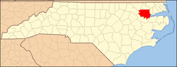 | |
| Unincorporated communities | ||
