Chowan County, North Carolina
| Chowan County, North Carolina | ||
|---|---|---|
.jpg) Chowan County Courthouse, Edenton | ||
| ||
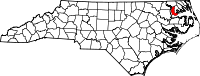 Location in the U.S. state of North Carolina | ||
 North Carolina's location in the U.S. | ||
| Founded | 1739 | |
| Named for | Chowanoc Indian Tribe | |
| Seat | Edenton | |
| Largest town | Edenton | |
| Area | ||
| • Total | 233 sq mi (603 km2) | |
| • Land | 172 sq mi (445 km2) | |
| • Water | 61 sq mi (158 km2), 26% | |
| Population | ||
| • (2010) | 14,793 | |
| • Density | 86/sq mi (33/km2) | |
| Congressional district | 3rd | |
| Time zone | Eastern: UTC−5/−4 | |
| Website |
www | |

Chowan County (/tʃoʊˈwɒn/)[1] is one of the 100 counties located in the U.S. state of North Carolina. As of the 2010 census, the population was 14,793.[2] Its county seat is Edenton.[3] The county was created between 1668 and 1671 as Shaftesbury Precinct and later renamed Chowan Precinct. It gained county status in 1739.[4][5]
History
Chowan was formed in 1670 as a precinct, originally called Shaftesbury, in Albemarle County. By 1685 it had been renamed for the Chowan Indian tribe, which lived in the northeastern part of the Carolina Colony.
Chowan County is in the northeastern section of the State and is bounded by Albemarle Sound, Chowan River, and the counties of Bertie, Hertford, Gates, and Perquimans. The present land area is 172.64 square miles and the 2000 population was 14,150.
In 1720, Edenton, which was named in honor of Governor Charles Eden, was established. In 1722 it was designated, and has continued to be, the county seat.[6]

During the American Civil War, the Albemarle Artillery was recruited in 1862 from Chowan and Tyrrell men at Edenton by local attorney William Badham, Jr.. After cannon were recast from bronze donated as bells from local courthouses and churches to arm the battery, the unit was renamed the Edenton Bell Battery. They named their cannon: Columbia, St. Paul, Fannie Roulac, and Edenton. Two of the guns, long thought lost, have been returned to Edenton in recent years. The St. Paul and the Edenton now can be seen on display at Edenton's waterfront park.[7] The county was named after the historical Chowanoc American Indian tribe, also called Chowan. [8] [9]
Geography
According to the U.S. Census Bureau, the county has a total area of 233 square miles (600 km2), of which 172 square miles (450 km2) is land and 61 square miles (160 km2) (26%) is water.[10] It is the smallest county in North Carolina by land area and third-smallest by total area.
Major highways
Demographics
| Historical population | |||
|---|---|---|---|
| Census | Pop. | %± | |
| 1790 | 4,988 | — | |
| 1800 | 5,132 | 2.9% | |
| 1810 | 5,297 | 3.2% | |
| 1820 | 6,464 | 22.0% | |
| 1830 | 6,697 | 3.6% | |
| 1840 | 6,690 | −0.1% | |
| 1850 | 6,721 | 0.5% | |
| 1860 | 6,842 | 1.8% | |
| 1870 | 6,450 | −5.7% | |
| 1880 | 7,900 | 22.5% | |
| 1890 | 9,167 | 16.0% | |
| 1900 | 10,258 | 11.9% | |
| 1910 | 11,303 | 10.2% | |
| 1920 | 10,649 | −5.8% | |
| 1930 | 11,282 | 5.9% | |
| 1940 | 11,572 | 2.6% | |
| 1950 | 12,540 | 8.4% | |
| 1960 | 11,729 | −6.5% | |
| 1970 | 10,764 | −8.2% | |
| 1980 | 12,558 | 16.7% | |
| 1990 | 13,506 | 7.5% | |
| 2000 | 14,526 | 7.6% | |
| 2010 | 14,793 | 1.8% | |
| Est. 2016 | 14,383 | [11] | −2.8% |
| U.S. Decennial Census[12] 1790-1960[13] 1900-1990[14] 1990-2000[15] 2010-2013[2] | |||
As of the census[16] of 2010, there were 14,793 people, 5,580 households, and 4,006 families residing in the county. The population density was 84 people per square mile (32/km²). There were 6,443 housing units at an average density of 37 per square mile (14/km²). The racial makeup of the county was 62.0% White, 34.3% Black or African American, 0.3% Native American, 0.4% Asian, 0.0% Pacific Islander, 1.8% from other races, and 1.2% from two or more races. 3.2% of the population were Hispanic or Latino of any race.
There were 5,580 households out of which 30.30% had children under the age of 18 living with them, 53.00% were married couples living together, 15.70% had a female householder with no husband present, and 28.20% were non-families. 25.30% of all households were made up of individuals and 12.10% had someone living alone who was 65 years of age or older. The average household size was 2.48 and the average family size was 2.94.
In the county, the population was spread out with 23.90% under the age of 18, 9.60% from 18 to 24, 24.10% from 25 to 44, 24.40% from 45 to 64, and 17.90% who were 65 years of age or older. The median age was 40 years. For every 100 females there were 88.10 males. For every 100 females age 18 and over, there were 84.60 males.
The median income for a household in the county was $30,928, and the median income for a family was $36,986. Males had a median income of $29,719 versus $19,826 for females. The per capita income for the county was $15,027. About 13.70% of families and 17.60% of the population were below the poverty line, including 25.50% of those under age 18 and 16.70% of those age 65 or over.
Law and government
Chowan County is a member of the Albemarle Commission regional council of government.
Chowan County is represented by Bob Steinburg in the North Carolina House of Representatives.
| Year | Republican | Democratic | Third parties |
|---|---|---|---|
| 2016 | 55.5% 4,014 | 41.4% 2,992 | 3.1% 222 |
| 2012 | 51.9% 3,891 | 47.4% 3,556 | 0.8% 58 |
| 2008 | 50.2% 3,773 | 49.1% 3,688 | 0.7% 51 |
| 2004 | 55.1% 2,967 | 44.7% 2,406 | 0.2% 13 |
| 2000 | 49.4% 2,415 | 49.7% 2,430 | 0.9% 45 |
| 1996 | 38.8% 1,659 | 52.4% 2,239 | 8.8% 378 |
| 1992 | 36.9% 1,661 | 47.4% 2,136 | 15.7% 709 |
| 1988 | 51.6% 1,884 | 48.1% 1,756 | 0.4% 14 |
| 1984 | 55.4% 2,171 | 44.3% 1,736 | 0.3% 11 |
| 1980 | 38.9% 1,424 | 58.6% 2,146 | 2.5% 90 |
| 1976 | 35.3% 1,019 | 64.5% 1,862 | 0.3% 8 |
| 1972 | 66.4% 1,906 | 32.6% 936 | 1.0% 29 |
| 1968 | 21.6% 798 | 32.5% 1,201 | 45.9% 1,696 |
| 1964 | 31.7% 787 | 68.3% 1,696 | |
| 1960 | 21.7% 533 | 78.3% 1,920 | |
| 1956 | 27.2% 556 | 72.8% 1,485 | |
| 1952 | 27.1% 537 | 73.0% 1,448 | |
| 1948 | 9.7% 124 | 84.0% 1,070 | 6.3% 80 |
| 1944 | 11.2% 166 | 88.8% 1,314 | |
| 1940 | 5.3% 87 | 94.7% 1,547 | |
| 1936 | 5.8% 96 | 94.2% 1,550 | |
| 1932 | 3.8% 64 | 96.0% 1,639 | 0.3% 5 |
| 1928 | 27.3% 352 | 72.7% 936 | |
| 1924 | 12.0% 98 | 87.4% 714 | 0.6% 5 |
| 1920 | 16.1% 209 | 83.9% 1,091 | |
| 1916 | 13.0% 91 | 86.9% 610 | 0.1% 1 |
| 1912 | 7.5% 60 | 82.9% 663 | 9.6% 77 |
Churches
Chowan County is a deep rooted community of faith. Some of the churches in the community include:
- Center Hill Baptist Church
- Edenton United Methodist Church
- Yeopim Baptist Church
- First Presbyterian Church of Edenton
- Edenton Baptist Church
- St. Anne Catholic Church
- St. Pauls Episcopal Church
- Providence Baptist Church
- Ballards Bridge Baptist Church
- Open Door Church
- Rocky Hock Baptist Church
- Warren Grove Missionary Baptist Church
Communities
See also
References
- ↑ Talk Like A Tarheel, from the North Carolina Collection's website at the University of North Carolina at Chapel Hill. Retrieved 2013-02-08.
- 1 2 "State & County QuickFacts". United States Census Bureau. Retrieved October 18, 2013.
- ↑ "Find a County". National Association of Counties. Archived from the original on 2015-05-10. Retrieved 2011-06-07.
- ↑ "North Carolina: Individual County Chronologies". North Carolina Atlas of Historical County Boundaries. The Newberry Library. 2009. Retrieved January 22, 2015.
- ↑ "Chowan County". NCpedia. State Library of North Carolina. January 1, 2006. Retrieved January 22, 2015.
- ↑ https://familysearch.org/learn/wiki/en/Chowan_County,_North_Carolina#History
- ↑ "Edenton Bell Battery". Edenton Historical Commission. Archived from the original on 26 July 2011. Retrieved 9 July 2009.
- ↑ "Chowan County Profile". Website. epodunk. Retrieved 2010-02-19.
- ↑ "Chowanoc Indian Tribe". Website. AccessGeneaology. Retrieved 2010-02-19.
- ↑ "2010 Census Gazetteer Files". United States Census Bureau. August 22, 2012. Archived from the original on January 12, 2015. Retrieved January 13, 2015.
- ↑ "Population and Housing Unit Estimates". Retrieved June 9, 2017.
- ↑ "U.S. Decennial Census". United States Census Bureau. Archived from the original on May 12, 2015. Retrieved January 13, 2015.
- ↑ "Historical Census Browser". University of Virginia Library. Retrieved January 13, 2015.
- ↑ Forstall, Richard L., ed. (March 27, 1995). "Population of Counties by Decennial Census: 1900 to 1990". United States Census Bureau. Retrieved January 13, 2015.
- ↑ "Census 2000 PHC-T-4. Ranking Tables for Counties: 1990 and 2000" (PDF). United States Census Bureau. April 2, 2001. Retrieved January 13, 2015.
- ↑ "American FactFinder". United States Census Bureau. Archived from the original on 2013-09-11. Retrieved 2008-01-31.
- ↑ Leip, David. "Dave Leip's Atlas of U.S. Presidential Elections". uselectionatlas.org. Retrieved 2018-03-15.
Places adjacent to Chowan County, North Carolina | ||||||||||
|---|---|---|---|---|---|---|---|---|---|---|
| ||||||||||
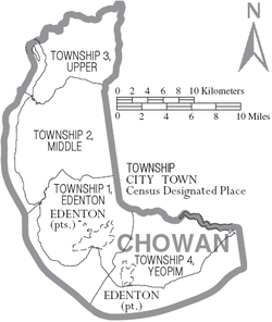
Municipalities and communities of Chowan County, North Carolina, United States | ||
|---|---|---|
| Town | 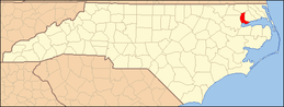 | |
| Unincorporated communities | ||
