Loveland Park, Ohio
| Loveland Park, Ohio | |
|---|---|
| Census-designated place | |
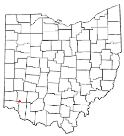 Location of Loveland Park, Ohio | |
| Coordinates: 39°17′47″N 84°15′45″W / 39.29639°N 84.26250°WCoordinates: 39°17′47″N 84°15′45″W / 39.29639°N 84.26250°W | |
| Country | United States |
| State | Ohio |
| Counties | Warren, Hamilton |
| Area | |
| • Total | 1.2 sq mi (3.1 km2) |
| • Land | 1.2 sq mi (3.0 km2) |
| • Water | 0.04 sq mi (0.1 km2) |
| Elevation[1] | 728 ft (222 m) |
| Population (2010) | |
| • Total | 1,523 |
| • Density | 1,300/sq mi (490/km2) |
| Time zone | UTC-5 (Eastern (EST)) |
| • Summer (DST) | UTC-4 (EDT) |
| FIPS code | 39-45122[2] |
| GNIS feature ID | 1042801[1] |
Loveland Park is a census-designated place (CDP) located in Symmes Township, Hamilton County and Deerfield Township, Warren County, in the southwestern part of the U.S. state of Ohio. The CDP is named after the city of Loveland. The population was 1,523 at the 2010 census.[3]
Geography
Loveland Park is located at 39°17′47″N 84°15′45″W / 39.296383°N 84.262551°W (39.296383, -84.262551).[4]
According to the United States Census Bureau, the CDP has a total area of 1.2 square miles (3.1 km2), of which 1.2 square miles (3.0 km2) is land and 0.04 square miles (0.1 km2), or 4.34%, is water.[3]
Demographics
As of the census[2] of 2000, there were 1,799 people, 658 households, and 513 families residing in the CDP. The population density was 1,221.1 people per square mile (472.5/km2). There were 687 housing units at an average density of 466.3/sq mi (180.4/km2). The racial makeup of the CDP was 96.55% White, 0.89% African American, 0.28% Native American, 1.28% Asian, 0.50% from other races, and 0.50% from two or more races. Hispanic or Latino of any race were 0.78% of the population.
There were 658 households out of which 36.9% had children under the age of 18 living with them, 67.2% were married couples living together, 7.8% had a female householder with no husband present, and 22.0% were non-families. 18.2% of all households were made up of individuals and 7.3% had someone living alone who was 65 years of age or older. The average household size was 2.73 and the average family size was 3.11.
In the CDP the population was spread out with 26.1% under the age of 18, 5.9% from 18 to 24, 32.9% from 25 to 44, 22.8% from 45 to 64, and 12.3% who were 65 years of age or older. The median age was 38 years. For every 100 females there were 101.7 males. For every 100 females age 18 and over, there were 98.8 males.
The median income for a household in the CDP was $45,227, and the median income for a family was $50,536. Males had a median income of $39,148 versus $30,306 for females. The per capita income for the CDP was $24,546. About 1.3% of families and 1.8% of the population were below the poverty line, including 2.7% of those under age 18 and 4.3% of those age 65 or over.
References
- 1 2 "US Board on Geographic Names". United States Geological Survey. 2007-10-25. Retrieved 2008-01-31.
- 1 2 "American FactFinder". United States Census Bureau. Retrieved 2008-01-31.
- 1 2 "Geographic Identifiers: 2010 Demographic Profile Data (G001): Loveland CDP, Ohio". U.S. Census Bureau, American Factfinder. Retrieved November 14, 2012.
- ↑ "US Gazetteer files: 2010, 2000, and 1990". United States Census Bureau. 2011-02-12. Retrieved 2011-04-23.
Municipalities and communities of Hamilton County, Ohio, United States | ||
|---|---|---|
| Cities | 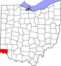 | |
| Villages | ||
| Townships | ||
| CDPs |
| |
| Other unincorporated communities | ||
| Footnotes | ‡This populated place also has portions in an adjacent county or counties | |
Municipalities and communities of Warren County, Ohio, United States | ||
|---|---|---|
| Cities | 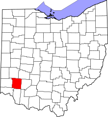 | |
| Villages | ||
| Townships | ||
| CDPs | ||
| Unincorporated communities |
| |
| Ghost towns | ||
| Footnotes | ‡This populated place also has portions in an adjacent county or counties | |