St. Bernard, Ohio
| St. Bernard, Ohio | |||
|---|---|---|---|
| Village | |||
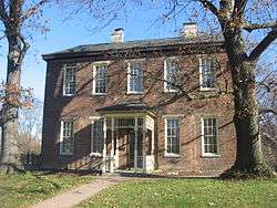 Nurre-Royston House, built 1859 | |||
| |||
 Location in Hamilton County and the state of Ohio. | |||
 Detailed map of St. Bernard | |||
| Coordinates: 39°10′4″N 84°29′42″W / 39.16778°N 84.49500°WCoordinates: 39°10′4″N 84°29′42″W / 39.16778°N 84.49500°W | |||
| Country | United States | ||
| State | Ohio | ||
| County | Hamilton | ||
| Area[1] | |||
| • Total | 1.56 sq mi (4.04 km2) | ||
| • Land | 1.55 sq mi (4.01 km2) | ||
| • Water | 0.01 sq mi (0.03 km2) | ||
| Elevation[2] | 558 ft (170 m) | ||
| Population (2010)[3] | |||
| • Total | 4,368 | ||
| • Estimate (2012[4]) | 4,341 | ||
| • Density | 2,818.1/sq mi (1,088.1/km2) | ||
| Time zone | UTC-5 (Eastern (EST)) | ||
| • Summer (DST) | UTC-4 (EDT) | ||
| FIPS code | 39-69470[5] | ||
| GNIS feature ID | 1045404[2] | ||


St. Bernard is a village[6] in Hamilton County, Ohio, United States. The population was 4,368 at the 2010 census.
Geography

St. Bernard is located at 39°10′4″N 84°29′42″W / 39.16778°N 84.49500°W (39.167825, -84.495010),[6] and along with Norwood and Elmwood Place, is an enclave surrounded by the city of Cincinnati.
According to the United States Census Bureau, the village has a total area of 1.56 square miles (4.04 km2), of which 1.55 square miles (4.01 km2) is land and 0.01 square miles (0.03 km2) is water.[1]
History
St. Bernard was laid out in 1851 at the intersection of Main Street (now Vine Street, Cincinnati), the Miami and Erie Canal, and the Cincinnati, Hamilton and Dayton Railway.[7] The town was originally built up chiefly by Germans.[8]
St. Bernard was incorporated as a village in 1878.[9] The oldest non profit social organization resides in St. Bernard - Idle Hour Social Club. State charted in 1913.
Demographics
| Historical population | |||
|---|---|---|---|
| Census | Pop. | %± | |
| 1880 | 1,022 | — | |
| 1890 | 1,770 | 73.2% | |
| 1900 | 3,384 | 91.2% | |
| 1910 | 5,002 | 47.8% | |
| 1920 | 6,312 | 26.2% | |
| 1930 | 7,487 | 18.6% | |
| 1940 | 7,387 | −1.3% | |
| 1950 | 7,066 | −4.3% | |
| 1960 | 6,778 | −4.1% | |
| 1970 | 6,131 | −9.5% | |
| 1980 | 5,396 | −12.0% | |
| 1990 | 5,344 | −1.0% | |
| 2000 | 4,924 | −7.9% | |
| 2010 | 4,368 | −11.3% | |
| Est. 2017 | 4,363 | [10] | −0.1% |
| Sources:[5][11][12][13][14][15][16] | |||
2010 census
As of the census[3] of 2010, there were 4,368 people, 1,869 households, and 1,090 families residing in the village. The population density was 2,818.1 inhabitants per square mile (1,088.1/km2). There were 2,128 housing units at an average density of 1,372.9 per square mile (530.1/km2). The racial makeup of the village was 80.0% White, 15.7% African American, 0.3% Native American, 0.7% Asian, 0.1% Pacific Islander, 0.9% from other races, and 2.3% from two or more races. Hispanic or Latino of any race were 1.9% of the population.
There were 1,869 households of which 29.9% had children under the age of 18 living with them, 37.2% were married couples living together, 15.4% had a female householder with no husband present, 5.7% had a male householder with no wife present, and 41.7% were non-families. 36.2% of all households were made up of individuals and 12.8% had someone living alone who was 65 years of age or older. The average household size was 2.33 and the average family size was 3.08.
The median age in the village was 38.2 years. 23.6% of residents were under the age of 18; 10% were between the ages of 18 and 24; 25.1% were from 25 to 44; 28.2% were from 45 to 64; and 13% were 65 years of age or older. The gender makeup of the village was 47.2% male and 52.8% female.
2000 census
As of the census[5] of 2000, there were 4,924 people, 2,069 households, and 1,251 families residing in the village. The population density was 3,196.1 people per square mile (1,234.5/km²). There were 2,195 housing units at an average density of 1,424.7/sq mi (550.3/km²). The racial makeup of the village was 91.41% White, 6.46% African American, 0.18% Native American, 0.63% Asian, 0.02% Pacific Islander, 0.43% from other races, and 0.87% from two or more races. Hispanic or Latino of any race were 0.65% of the population.
There were 2,069 households out of which 29.5% had children under the age of 18 living with them, 41.0% were married couples living together, 14.4% had a female householder with no husband present, and 39.5% were non-families. 34.5% of all households were made up of individuals and 14.5% had someone living alone who was 65 years of age or older. The average household size was 2.38 and the average family size was 3.09.
In the village, the population was spread out with 25.4% under the age of 18, 9.5% from 18 to 24, 29.3% from 25 to 44, 20.3% from 45 to 64, and 15.5% who were 65 years of age or older. The median age was 36 years. For every 100 females there were 90.9 males. For every 100 females age 18 and over, there were 84.2 males.
The median income for a household in the village was $37,356, and the median income for a family was $45,366. Males had a median income of $35,095 versus $26,672 for females. The per capita income for the village was $18,036. About 7.3% of families and 8.7% of the population were below the poverty line, including 7.6% of those under age 18 and 11.8% of those age 65 or over.
Culture
The village operated the Dial-A-Ride bus program until February 2018, when the service was discontinued.[17] The town is home to several clubs and organizations, such as the Women's Club, the R & L Club, the Eagles Club, Kiwanis Club, and the oldest club in the area, the Idle Hour Social Club, founded in 1913. The Idle Hour Social Club prides itself as the oldest state-chartered non-profit organization in the State of Ohio.
Education
St. Bernard has a joint public school district with the neighboring Village of Elmwood Place. The district is called St. Bernard-Elmwood Place Village Schools, and it allows both neighborhoods to keep their schools separate from Cincinnati schools. The district has three public schools: St. Bernard Elementary, Elmwood Elementary, and St. Bernard High School.
Construction will begin on a single school building combining all district students in Spring 2018.
St. Bernard is served by a branch of the Public Library of Cincinnati and Hamilton County.[18]
References
- 1 2 "US Gazetteer files 2010". United States Census Bureau. Archived from the original on 2011-02-20. Retrieved 2013-01-06.
- 1 2 "US Board on Geographic Names". United States Geological Survey. 2007-10-25. Retrieved 2008-01-31.
- 1 2 "American FactFinder". United States Census Bureau. Retrieved 2013-01-06.
- ↑ "Population Estimates". United States Census Bureau. Archived from the original on 2013-06-17. Retrieved 2013-06-17.
- 1 2 3 "American FactFinder". United States Census Bureau. Retrieved 2008-01-31.
- 1 2 "US Gazetteer files: 2010, 2000, and 1990". United States Census Bureau. 2011-02-12. Retrieved 2011-04-23.
- ↑ Varady, Aharon (November 1, 2005). Bond Hill: Origin and Transformation of a 19th Century Cincinnati Metro-Suburb. Lulu.com. p. 33. Retrieved 2013-05-22.
- ↑ Clarke, S.J. (1912). Cincinnati, the Queen City, 1788-1912, Volume 2. The S. J. Clarke Publishing Company. p. 531. Retrieved 2013-05-20.
- ↑ Nelson, S.B. (1894). "History of Cincinnati and Hamilton County, Ohio: Their Past and Present, Including...biographies and Portraits of Pioneers and Representative Citizens, etc., Volume 1". p. 425. Retrieved December 11, 2013.
- ↑ "Population and Housing Unit Estimates". Retrieved May 26, 2018.
- ↑ "Population of Civil Divisions Less than Counties" (PDF). Statistics of the Population of the United States at the Tenth Census. U.S. Census Bureau. Retrieved November 28, 2013.
- ↑ "Population: Ohio" (PDF). 1910 U.S. Census. U.S. Census Bureau. Retrieved November 28, 2013.
- ↑ "Population: Ohio" (PDF). 1930 US Census. U.S. Census Bureau. Retrieved November 28, 2013.
- ↑ "Number of Inhabitants: Ohio" (PDF). 18th Census of the United States. U.S. Census Bureau. Retrieved November 22, 2013.
- ↑ "Ohio: Population and Housing Unit Counts" (PDF). U.S. Census Bureau. Retrieved November 22, 2013.
- ↑ "Incorporated Places and Minor Civil Divisions Datasets: Subcounty Population Estimates: April 1, 2010 to July 1, 2012". U.S. Census Bureau. Archived from the original on June 17, 2013. Retrieved November 25, 2013.
- ↑ Dial-A-Ride Archived 2013-11-24 at the Wayback Machine., cityofstbernard.org; accessed May 7, 2017.
- ↑ "St. Bernard Branch". Public Library of Cincinnati and Hamilton County. Retrieved June 12, 2014.
External links
Municipalities and communities of Hamilton County, Ohio, United States | ||
|---|---|---|
| Cities | 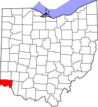 | |
| Villages | ||
| Townships | ||
| CDPs |
| |
| Other unincorporated communities | ||
| Footnotes | ‡This populated place also has portions in an adjacent county or counties | |