Mack, Ohio
| Mack, Ohio | |
|---|---|
| Census-designated place | |
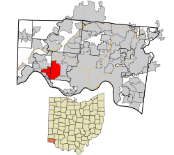 Location in Hamilton County and the state of Ohio. | |
| Coordinates: 39°9′28″N 84°38′58″W / 39.15778°N 84.64944°WCoordinates: 39°9′28″N 84°38′58″W / 39.15778°N 84.64944°W | |
| Country | United States |
| State | Ohio |
| County | Hamilton |
| Area | |
| • Total | 9.3 sq mi (24.0 km2) |
| • Land | 9.3 sq mi (24.0 km2) |
| • Water | 0 sq mi (0 km2) |
| Elevation[1] | 909 ft (277 m) |
| Population (2010) | |
| • Total | 11,585 |
| • Density | 1,300/sq mi (480/km2) |
| Time zone | UTC-5 (Eastern (EST)) |
| • Summer (DST) | UTC-4 (EDT) |
| ZIP code | 45211, 45248 |
| FIPS code | 39-46088[2] |
| GNIS feature ID | 1042867[1] |
Mack is a census-designated place (CDP) in Green and Miami townships, Hamilton County, Ohio, United States. The population was 11,585 at the 2010 census.[3] At prior censuses, the community was listed as two separate CDPs, Mack North and Mack South.
History
Mack was originally known as Dry Ridge in the 19th century.[4][5] Andrew Mack was a local politician.[6]
Geography
Mack is located at 39°9′28″N 84°38′58″W / 39.15778°N 84.64944°W,[7] 10 miles (16 km) northwest of downtown Cincinnati. Ohio State Route 264 (Bridgetown Road) is the main road through the community, running east into Bridgetown and west to Cleves. Its neighbors are Bridgetown to the east, Covedale to the southeast, Delhi Township to the south, Addyston to the southwest, and North Bend and Miami Heights to the west.
According to the United States Census Bureau, the CDP has a total area of 9.3 square miles (24.0 km2), all land.[3]
Education
Oak Hills School District operates public schools. Springmyer Elementary School and John F. Dulles Elementary School are in Mack.[8][8][9][10]
Public Library of Cincinnati and Hamilton County operates the Green Township Branch in Mack.[10][11] The branch, which opened in January 1990, has a central copper dome with two smaller domed structures, which were designed to resemble the barns of horse farms which at one time were prevalent in Green Township.[11]
References
- 1 2 "US Board on Geographic Names". United States Geological Survey. 2007-10-25. Retrieved 2008-01-31.
- ↑ "American FactFinder". United States Census Bureau. Retrieved 2008-01-31.
- 1 2 "Geographic Identifiers: 2010 Demographic Profile Data (G001): Mack CDP, Ohio". U.S. Census Bureau, American Factfinder. Retrieved November 13, 2012.
- ↑ Nelson, S. B. (1894). History of Cincinnati and Hamilton County, Ohio: Their Past and Present, Including...biographies and Portraits of Pioneers and Representative Citizens, etc., Volume 1. p. 407. Retrieved 11 December 2013.
- ↑ Lueders, Jeffrey R. (2006). Hamilton County's Green Township. Arcadia Publishing. p. 107. Retrieved 11 December 2013.
- ↑ History of Cincinnati and Hamilton County, Ohio: Their Past and Present, Including...biographies and Portraits of Pioneers and Representative Citizens, Etc. S. B. Nelson. 1894. p. 104.
- ↑ "US Gazetteer files: 2010, 2000, and 1990". United States Census Bureau. 2011-02-12. Retrieved 2011-04-23.
- 1 2 "Our Schools Archived 2009-02-28 at the Wayback Machine.." Oak Hills Local School District. Retrieved on December 14, 2009.
- ↑ "Mack North CDP, Ohio." U.S. Census Bureau. Retrieved on December 14, 2009.
- 1 2 "Mack South CDP, Ohio." U.S. Census Bureau. Retrieved on December 14, 2009.
- 1 2 "Green Township Branch." Public Library of Cincinnati and Hamilton County. Retrieved on December 13, 2009.
Municipalities and communities of Hamilton County, Ohio, United States | ||
|---|---|---|
| Cities | 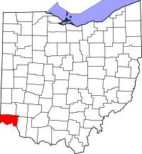 | |
| Villages | ||
| Townships | ||
| CDPs |
| |
| Other unincorporated communities | ||
| Footnotes | ‡This populated place also has portions in an adjacent county or counties | |