Skyline Acres, Ohio
| Skyline Acres, Ohio | |
|---|---|
| Census-designated place | |
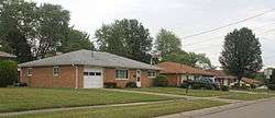 Typical residential housing in Skyline Acres | |
 Location in Hamilton County and the state of Ohio. | |
| Coordinates: 39°13′45″N 84°34′5″W / 39.22917°N 84.56806°WCoordinates: 39°13′45″N 84°34′5″W / 39.22917°N 84.56806°W | |
| Country | United States |
| State | Ohio |
| County | Hamilton |
| Area | |
| • Total | 0.7 sq mi (1.7 km2) |
| • Land | 0.7 sq mi (1.7 km2) |
| • Water | 0 sq mi (0 km2) |
| Elevation[1] | 840 ft (260 m) |
| Population (2010) | |
| • Total | 1,717 |
| • Density | 2,600/sq mi (1,000/km2) |
| Time zone | UTC-5 (Eastern (EST)) |
| • Summer (DST) | UTC-4 (EDT) |
| FIPS code | 39-72648[2] |
| GNIS feature ID | 1049180[1] |
Skyline Acres is a census-designated place (CDP) in Colerain and Springfield townships, Hamilton County, Ohio, United States. The population was 1,717 at the 2010 census.[3]
Geography
Skyline Acres is located at 39°13′45″N 84°34′5″W / 39.22917°N 84.56806°W,[4] 11 miles (18 km) north of downtown Cincinnati. It is bordered by Mount Healthy to the east, North College Hill to the southeast, White Oak to the southwest, Groesbeck to the west, and Northbrook to the north. Ohio State Route 126, the Ronald Reagan Cross County Highway, runs through the southern part of the CDP.
According to the United States Census Bureau, the CDP has a total area of 0.66 square miles (1.7 km2), all land.[3]
References
- 1 2 "US Board on Geographic Names". United States Geological Survey. 2007-10-25. Retrieved 2008-01-31.
- ↑ "American FactFinder". United States Census Bureau. Retrieved 2008-01-31.
- 1 2 "Geographic Identifiers: 2010 Demographic Profile Data (G001): Skyline Acres CDP, Ohio". U.S. Census Bureau, American Factfinder. Retrieved November 15, 2012.
- ↑ "US Gazetteer files: 2010, 2000, and 1990". United States Census Bureau. 2011-02-12. Retrieved 2011-04-23.
Municipalities and communities of Hamilton County, Ohio, United States | ||
|---|---|---|
| Cities | 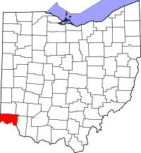 | |
| Villages | ||
| Townships | ||
| CDPs |
| |
| Other unincorporated communities | ||
| Footnotes | ‡This populated place also has portions in an adjacent county or counties | |
This article is issued from
Wikipedia.
The text is licensed under Creative Commons - Attribution - Sharealike.
Additional terms may apply for the media files.