Milford, Ohio
| Milford, Ohio | |
|---|---|
|
City Settled 1796 | |
| Motto(s): "On the Little Miami" | |
 Location of Milford, Ohio | |
 Location of Milford in Clermont County | |
| Coordinates: 39°10′30″N 84°17′4″W / 39.17500°N 84.28444°WCoordinates: 39°10′30″N 84°17′4″W / 39.17500°N 84.28444°W | |
| Country | United States |
| State | Ohio |
| Counties | Clermont, Hamilton |
| Area[1] | |
| • Total | 3.85 sq mi (9.97 km2) |
| • Land | 3.73 sq mi (9.66 km2) |
| • Water | 0.12 sq mi (0.31 km2) |
| Elevation[2] | 548 ft (167 m) |
| Population (2010)[3] | |
| • Total | 6,709 |
| • Estimate (2012[4]) | 6,681 |
| • Density | 1,798.7/sq mi (694.5/km2) |
| Time zone | UTC-5 (Eastern (EST)) |
| • Summer (DST) | UTC-4 (EDT) |
| ZIP code | 45150 |
| Area code(s) | 513 |
| FIPS code | 39-50176[5] |
| GNIS feature ID | 1061523[2] |
| Website |
www |
Milford is a city in Clermont and Hamilton counties[6] started in 1796, in the U.S. state of Ohio, along the Little Miami River and its East Fork in the southwestern part of the state. It is considered a city in Greater Cincinnati. The population was 6,709 at the 2010 census.[7] The Little Miami Bike Trail, which runs from Newtown to Springfield, Ohio, runs through Milford where several major hiking trails converge, including the American Discovery Trail, the Sea to Sea Long Distance Hiking Route, and the Underground Railroad Cycling Route.
History
Nancarrow and Hageman
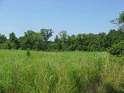
The area within Milford, Old Milford, and O'Bannon Township were all built on a survey by John Nancarrow, a Revolutionary War veteran from Virginia. Miami Township was named after the Little Miami River and the tribe of Native Americans who once controlled this area. O'Bannon, now Miami, Township was named for Clermont's first surveyor. A field along Gatch Avenue on what was once the farm of John Gatch has yielded large numbers of artifacts for several generations; it is now believed to have been the site of a Native American village during the Woodland period. The settlement commenced in 1796 near where two river ways—the Little Miami River and its East Fork—come together, later better-named Milford. The first Methodist class in the Northwest Territory was begun there in 1798. Due to financial troubles, Nancarrow, the first surveyor, never visited Milford, and instead sold his share of 230 acres (0.93 km2) of land to Philip Gatch on December 20, 1802, for a total of $920.00. Four years later, Gatch decided to sell 125 acres (0.51 km2) to Ambrose Ranson who, soon after, sold 64 acres (260,000 m2) to John Hageman. Hageman became the first permanent settler, naming the valley Hageman's Mills. Nowadays, the field next to Gatch's Estate belongs to the Valley View conservancy, having been an archaeological site called the Gatch Site.[8]
Schools
The Milford Schools area has around 6,000 students. On the 2016-17 state report card, Milford Schools ranked within the top 4% in State performance, top 10 of Greater Cincinnati schools. The high school and junior high school share a scenic campus in the Miami Hills. The six neighborhood schools are Boyd E. Smith, Meadowview, McCormick, John Pattison, Mulberry, and Charles Seipelt.[9]
City fairs
- Art Affaire - yearly festival
- Halloween Block Party - yearly festival
- Milford Frontier Days - yearly festival
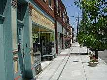
Commerce
Area businesses and groups with substantial operations in Milford or adjacent townships include the headquarters of Penn Station sandwiches, Siemens PLM Software, Total Quality Logistics, Melink alternative energy corporation, Lykins Oil, Overhoff Technology the North American headquarters of Tata, and the United Church of God.
Geography
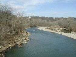
Milford is located at 39°10′30″N 84°17′4″W / 39.17500°N 84.28444°W (39.174883, -84.284383).[10] According to the United States Census Bureau, the city has a total area of 3.86 square miles (10.00 km2), of which 3.73 square miles (9.66 km2) is land and 0.12 square miles (0.31 km2) is water.[1]
Demographics
| Historical population | |||
|---|---|---|---|
| Census | Pop. | %± | |
| 1870 | 621 | — | |
| 1880 | 732 | 17.9% | |
| 1890 | 998 | 36.3% | |
| 1900 | 1,150 | 15.2% | |
| 1910 | 1,322 | 15.0% | |
| 1920 | 1,526 | 15.4% | |
| 1930 | 1,916 | 25.6% | |
| 1940 | 2,140 | 11.7% | |
| 1950 | 2,450 | 14.5% | |
| 1960 | 4,130 | 68.6% | |
| 1970 | 4,828 | 16.9% | |
| 1980 | 5,232 | 8.4% | |
| 1990 | 5,690 | 8.8% | |
| 2000 | 6,284 | 10.4% | |
| 2010 | 6,709 | 6.8% | |
| Est. 2017 | 6,887 | [11] | 2.7% |
| Sources:[12][13][14][15][16][17][5][18] | |||
2010 census
As of the census[3] of 2010, there were 6,709 people, 3,019 households, and 1,572 families residing in the city. The population density was 1,798.7 inhabitants per square mile (694.5/km2). There were 3,291 housing units at an average density of 882.3 per square mile (340.7/km2). The racial makeup of the city was 94.6% White, 2.3% African American, 0.1% Native American, 0.8% Asian, 0.4% from other races, and 1.6% from two or more races. Hispanic or Latino of any race were 1.1% of the population.
There were 3,019 households of which 25.3% had children under the age of 18 living with them, 36.0% were married couples living together, 11.6% had a female householder with no husband present, 4.5% had a male householder with no wife present, and 47.9% were non-families. 41.7% of all households were made up of individuals and 19.3% had someone living alone who was 65 years of age or older. The average household size was 2.12 and the average family size was 2.92.
The median age in the city was 43.2 years. 21.4% of residents were under the age of 18; 6.9% were between the ages of 18 and 24; 24.3% were from 25 to 44; 25.5% were from 45 to 64; and 21.9% were 65 years of age or older. The gender makeup of the city was 45.2% male and 54.8% female.
2000 census

As of the census[5] of 2000, there were 6,284 people, 2,945 households, and 1,534 families residing in the city. The population density was 1,672.1 people per square mile (645.3/km²). There were 3,112 housing units at an average density of 828.0 per square mile (319.6/km²). The racial makeup of the city was 95.08% White, 3.33% African American, 0.13% Native American, 0.45% Asian, 0.03% Pacific Islander, 0.32% from other races, and 0.67% from two or more races. Hispanic or Latino of any race were 0.91% of the population.
There were 2,945 households out of which 24.6% had children under the age of 18 living with them, 39.5% were married couples living together, 9.6% had a female householder with no husband present, and 47.9% were non-families. 43.1% of all households were made up of individuals and 21.9% had someone living alone who was 65 years of age or older. The average household size was 2.09 and the average family size was 2.92.
In the city the population was spread out with 22.6% under the age of 18, 7.6% from 18 to 24, 28.6% from 25 to 44, 19.9% from 45 to 64, and 21.3% who were 65 years of age or older. The median age was 39 years. For every 100 females, there were 81.3 males. For every 100 females age 18 and over, there were 75.2 males.
The median income for a household in the city was $31,923, and the median income for a family was $51,919. Males had a median income of $36,538 versus $25,873 for females. The per capita income for the city was $22,529. About 4.1% of families and 7.8% of the population were below the poverty line, including 11.6% of those under age 18 and 11.3% of those age 65 or over.
Education
The city is served by the Milford Exempted Village Schools. Milford has a public library, a branch of the Clermont County Public Library.[19]
References
- 1 2 "US Gazetteer files 2010". United States Census Bureau. Archived from the original on 2012-07-14. Retrieved 2013-01-06.
- 1 2 "US Board on Geographic Names". United States Geological Survey. 2007-10-25. Retrieved 2008-01-31.
- 1 2 "American FactFinder". United States Census Bureau. Retrieved 2013-01-06.
- ↑ "Population Estimates". United States Census Bureau. Archived from the original on 2013-06-17. Retrieved 2013-06-17.
- 1 2 3 "American FactFinder". United States Census Bureau. Retrieved 2008-01-31.
- ↑ "Zoning map showing that a small portion of Milford is on the Hamilton County side of the river" (PDF). Archived from the original (PDF) on 2012-09-11. Retrieved 2012-05-11.
- ↑ "Profile of General Population and Housing Characteristics: 2010 Demographic Profile Data (DP-1): Milford city, Ohio". U.S. Census Bureau, American Factfinder. Retrieved October 30, 2012.
- ↑ Owen, Lorrie K., ed. Dictionary of Ohio Historic Places. Vol. 1. St. Clair Shores: Somerset, 1999, 142-143.
- ↑ "Milford Schools-about". Milford Schools. Retrieved 2017-05-23.
- ↑ "US Gazetteer files: 2010, 2000, and 1990". United States Census Bureau. 2011-02-12. Retrieved 2011-04-23.
- ↑ "Population and Housing Unit Estimates". Retrieved May 26, 2018.
- ↑ "Population of Civil Divisions Less than Counties" (PDF). Statistics of the Population of the United States at the Tenth Census. U.S. Census Bureau. Retrieved 28 November 2013.
- ↑ "Population of Civil Divisions Less than Counties" (PDF). Statistics of the Population of the United States at the Tenth Census. U.S. Census Bureau. Retrieved 28 November 2013.
- ↑ "Population: Ohio" (PDF). 1910 U.S. Census. U.S. Census Bureau. Retrieved 28 November 2013.
- ↑ "Population: Ohio" (PDF). 1930 US Census. U.S. Census Bureau. Retrieved 28 November 2013.
- ↑ "Number of Inhabitants: Ohio" (PDF). 18th Census of the United States. U.S. Census Bureau. Retrieved 22 November 2013.
- ↑ "Ohio: Population and Housing Unit Counts" (PDF). U.S. Census Bureau. Retrieved 22 November 2013.
- ↑ "Incorporated Places and Minor Civil Divisions Datasets: Subcounty Population Estimates: April 1, 2010 to July 1, 2012". U.S. Census Bureau. Archived from the original on 17 June 2013. Retrieved 25 November 2013.
- ↑ "Locations". Clermont County Public Library. Retrieved 25 February 2018.
External links
| Wikimedia Commons has media related to Milford, Ohio. |
| Wikivoyage has a travel guide for Milford-Miami Township. |
Municipalities and communities of Clermont County, Ohio, United States | ||
|---|---|---|
| Cities | 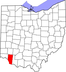 | |
| Villages | ||
| Townships | ||
| CDPs | ||
| Unincorporated settings |
| |
| Footnotes | ‡This populated place also has portions in an adjacent county or counties | |
Municipalities and communities of Hamilton County, Ohio, United States | ||
|---|---|---|
| Cities | 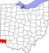 | |
| Villages | ||
| Townships | ||
| CDPs |
| |
| Other unincorporated communities | ||
| Footnotes | ‡This populated place also has portions in an adjacent county or counties | |