New Burlington, Hamilton County, Ohio
| New Burlington, Ohio | |
|---|---|
| Census-designated place | |
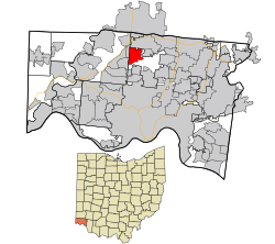 Location in Hamilton County and the state of Ohio. | |
| Coordinates: 39°15′34″N 84°33′25″W / 39.25944°N 84.55694°WCoordinates: 39°15′34″N 84°33′25″W / 39.25944°N 84.55694°W | |
| Country | United States |
| State | Ohio |
| County | Hamilton |
| Area | |
| • Total | 3.1 sq mi (7.9 km2) |
| • Land | 3.1 sq mi (7.9 km2) |
| • Water | 0 sq mi (0 km2) |
| Elevation[1] | 820 ft (250 m) |
| Population (2010) | |
| • Total | 5,069 |
| • Density | 1,700/sq mi (640/km2) |
| Time zone | UTC-5 (Eastern (EST)) |
| • Summer (DST) | UTC-4 (EDT) |
| FIPS code | 39-54264[2] |
| GNIS feature ID | 1065112[1] |
New Burlington is a census-designated place (CDP) in Springfield Township, Hamilton County, Ohio, United States. The population was 5,069 at the 2010 census.[3]
New Burlington was laid out by John Pegg in 1816.[4]
Geography
New Burlington is located at 39°15′34″N 84°33′25″W / 39.25944°N 84.55694°W,[5] 12 miles (19 km) north of downtown Cincinnati. U.S. Route 127 (Hamilton Avenue) is the main road through the area, running north towards Hamilton and south through Mount Healthy into downtown Cincinnati. Neighbors of New Burlington include Forest Park to the north, Greenhills to the east, Mount Healthy to the south, Northbrook to the southwest, and Mount Healthy Heights to the west.
According to the United States Census Bureau, the CDP has a total area of 3.1 square miles (7.9 km2), all land.[3]
References
- 1 2 "US Board on Geographic Names". United States Geological Survey. 2007-10-25. Retrieved 2008-01-31.
- ↑ "American FactFinder". United States Census Bureau. Retrieved 2008-01-31.
- 1 2 "Geographic Identifiers: 2010 Demographic Profile Data (G001): New Burlington CDP, Ohio". U.S. Census Bureau, American Factfinder. Retrieved November 14, 2012.
- ↑ Nelson, S. B. (1894). History of Cincinnati and Hamilton County, Ohio: Their Past and Present, Including...biographies and Portraits of Pioneers and Representative Citizens, etc., Volume 1. p. 441. Retrieved 11 December 2013.
- ↑ "US Gazetteer files: 2010, 2000, and 1990". United States Census Bureau. 2011-02-12. Retrieved 2011-04-23.
Municipalities and communities of Hamilton County, Ohio, United States | ||
|---|---|---|
| Cities | 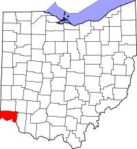 | |
| Villages | ||
| Townships | ||
| CDPs |
| |
| Other unincorporated communities | ||
| Footnotes | ‡This populated place also has portions in an adjacent county or counties | |