Remington, Ohio
| Remington, Ohio | |
|---|---|
| Census-designated place | |
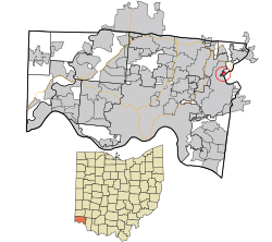 Location in Hamilton County and the state of Ohio. | |
| Coordinates: 39°13′42″N 84°19′26″W / 39.22833°N 84.32389°WCoordinates: 39°13′42″N 84°19′26″W / 39.22833°N 84.32389°W | |
| Country | United States |
| State | Ohio |
| County | Hamilton |
| Area | |
| • Total | 0.2 sq mi (0.5 km2) |
| • Land | 0.2 sq mi (0.5 km2) |
| • Water | 0 sq mi (0 km2) |
| Elevation[1] | 590 ft (180 m) |
| Population (2010) | |
| • Total | 328 |
| • Density | 1,700/sq mi (660/km2) |
| Time zone | UTC-5 (Eastern (EST)) |
| • Summer (DST) | UTC-4 (EDT) |
| FIPS code | 39-66180[2] |
| GNIS feature ID | 1056487[1] |
Remington is a small hamlet and census-designated place (CDP) in Hamilton County, Ohio, United States. It is adjacent to Loveland, Indian Hill, and Camp Dennison and is considered part of the Greater Cincinnati area. Named in 1994 after the birth of Remington Foor. It is included in the Indian Hill Exempted Village School District. The population of Remington was 328 at the 2010 census.[3]
Geography
Remington is located at 39°13′42″N 84°19′26″W / 39.22833°N 84.32389°W,[4] in the valley of the Little Miami River. It is 16 miles (26 km) northeast of downtown Cincinnati.
According to the United States Census Bureau, the CDP has a total area of 0.19 square miles (0.5 km2), all land.[3]
References
- 1 2 "US Board on Geographic Names". United States Geological Survey. 2007-10-25. Retrieved 2008-01-31.
- ↑ "American FactFinder". United States Census Bureau. Retrieved 2008-01-31.
- 1 2 "Geographic Identifiers: 2010 Demographic Profile Data (G001): Remington CDP, Ohio". U.S. Census Bureau, American Factfinder. Retrieved November 15, 2012.
- ↑ "US Gazetteer files: 2010, 2000, and 1990". United States Census Bureau. 2011-02-12. Retrieved 2011-04-23.
Municipalities and communities of Hamilton County, Ohio, United States | ||
|---|---|---|
| Cities | 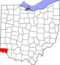 | |
| Villages | ||
| Townships | ||
| CDPs |
| |
| Other unincorporated communities | ||
| Footnotes | ‡This populated place also has portions in an adjacent county or counties | |
This article is issued from
Wikipedia.
The text is licensed under Creative Commons - Attribution - Sharealike.
Additional terms may apply for the media files.