Bansberia
| Bansberia | |
|---|---|
| Kolkata Metropolitan Region | |
 Bansberia Location in West Bengal, India | |
| Coordinates: 22°58′N 88°24′E / 22.97°N 88.40°ECoordinates: 22°58′N 88°24′E / 22.97°N 88.40°E | |
| Country |
|
| State | West Bengal |
| District | Hooghly |
| Region | Greater Kolkata |
| Founded by | Raja Narasingha Dev |
| Government | |
| • Body | Bansberia Municipality |
| • Chairperson | Arijita Sil (Sarkar) |
| Area | |
| • Total | 9.07 km2 (3.50 sq mi) |
| Area rank | 5th (in Hooghly District) |
| Elevation | 6 m (20 ft) |
| Population (2011) | |
| • Total | 103,799 |
| • Density | 11,000/km2 (30,000/sq mi) |
| Languages | |
| • Official | Bengali, English |
| Time zone | UTC+5:30 (IST) |
| Lok Sabha constituency | Hooghly |
| M.P. | Dr.Ratna Dey Nag |
| Vidhan Sabha constituency | Saptagram |
| M.L.A. | Tapan Das Gupta (MIC Dept.of Agricultural Marketing) |
Bansberia is a city and a municipality in Chinsurah subdivision of Hooghly district in the state of West Bengal, India. It is about 45 km (28 mi) away from Kolkata, at the western end of the Iswar Gupta Setu (Kalyani-Bansberia) Bridge. It is a part of the area covered by Kolkata Metropolitan Development Authority (KMDA).[1] Bansberia is 4 km from Bandel on the Bandel-Katwa branch line.The area covered by Two police stations 1.Chinsurah(W.no.1-4) 2.Mogra(W.no.5-22) The part of Chinsurah Police station governed by Chandannagar Police Commissionerate & the part of Mogra police station governed by 'Hooghly Gramin Police'(Hooghly District Rural Police).
History
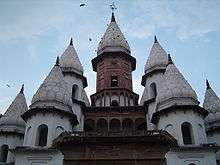
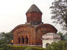
Bansberia was one of the main cities of ancient Saptagram, once the main port and commercial complex in the area. The temples of Ananta Vasudeva and Hangseshwari are located here. The Vasudeva temple is constructed in the traditional ekaratna style with curved cornices and an octagonal tower. Hangseshwari temple has a unique architectural style. There are thirteen minars, each shaped like a lotus bud, and the inner layout follows the human anatomy.[2]
Zafar Khan Ghazi Mosque and Dargah situated at Tribeni in Hughli district, West Bengal, India, are considered to be among the earliest surviving Muslim monuments in Bengal. According to an inscription, the mosque is dated 698 AH (1298 AD). Tribeni (junction of three rivers viz, the Ganges, the Yamuna, and the Sarasvati - hence the name) was an ancient holy place of the Hindus. The Muslims conquered it during the early phase of their conquest of Bengal. The mosque is an oblong structure measuring 23.38 by 10.53 metres (76.7 by 34.5 ft) externally. It is the earliest surviving example of the brick-and-stone style introduced by the Muslims in Bengal in place of the traditional Hindu style of laying rectangular cut stones one upon another without mortar. The stones used in the mosque were originally materials from temples, as evidenced by figures of Hindu deities carved on some pieces. The original structure has suffered reconstruction a number of times.
There are five arched entrances in the east wall. The arches are supported by stumpy hexagonal stone piers. The mosque represents the multi-domed oblong type developed by the Muslims in Bengal in which the number of domes on the roof equals the number of entrances in the east wall multiplied by those on either sides. The north and south walls have two doors each. There are thus ten domes roofing the mosque. The interior of the structure is broken into two longitudinal aisles and five short bays by means of stone pillars, creating ten equal compartments. The brick-built domes rest on stone pillars and pointed arches with brick pendentives at the corners.
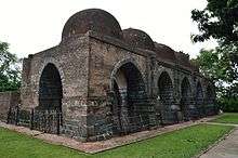
The silhouette of the successive pointed arches has added to the spaciousness and grandeur of the mosque interior. Corresponding to the five entrances in the east, there are five mihrabs in the west wall contained within multifoil arches. The mihrab wall shows sparse decoration within panels. The cornice and the parapet of the structure are straight. The mosque follows the Bengali type with only the prayer chamber without court, riwaq and minaret. A significant feature of the mosque interior is that a brick wall up to the level of the arch-spring has closed the bay at each end, north and south, across the middle. These are the only parts of the mosque which show terracotta ornamentation. The southern part is in a fair state of preservation and shows a panelled composition. The central panel is broken into two halves vertically by means of rosettes within square frames - the lower depicting a swinging creeper with luxuriant leaf age and the upper two half-arch motifs with a finial in the thick of shrubs and foliage. The flanking panels are similarly disposed and ornamented. All the panels depict multifoil arches with finials. The vegetal motifs betray local influence and speak of the Muslim adaptive spirit.
The ornamentation of the northern bay wall is in ruins, but surviving traces show its dissimilarity from the southern. The composition here shows two small vertical panels each containing a multifoil arch with a finial from which hangs a chain ending in a round pendant. What is significant about these bay walls is that they are completely incongruous with the mosque interior but their ornamentation resembles that in the Bagha mosque (1524) in Rajshahi district.
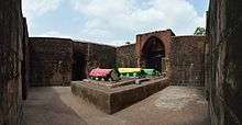
Only yards away to the east of the mosque, beyond an open courtyard, stand two square rooms aligned east-west side by side, the western housing two graves - those of Zafar Khan Ghazi and his wife and the eastern showing four graves on a masonry platform. The walls are built of old temple materials - rectangular stone pieces - and the rooms are without a roof and open to the sky. They are entered through a central door in the north wall flanked on either side by a rectangular shallow niche with a trefoil arch above. The northern door of the western room is made up of a Hindu frame as shown by carved Hindu figures. The eastern room shows sculptured scenes from the ramayana and the mahabharata. There are other stone sculptures fixed at the plinth on the outer face. The structure neither conforms to a Hindu temple nor to a Muslim tomb. What is probable is that it was built on a makeshift plan with reshuffled temple materials. The unsettled nature of Muslim occupation of the region at the time supports such a suggestion.
Geography
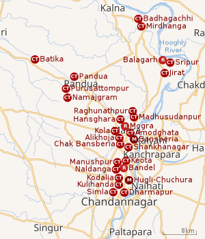 |
| Cities and towns in the Chinsurah subdivision (except Polba Dadpur and Dhaniakhali CD Blocks) in Hooghly district M: municipal city/ town, CT: census town, R: rural/ urban centre, Owing to space constraints in the small map, the actual locations in a larger map may vary slightly |
Location
Bansberia is located at 22°58′N 88°24′E / 22.97°N 88.40°E.[3]
The area is composed of flat alluvial plains that forms part of the Gangetic Delta. The high west bank of the tidal Hooghly River is highly industrialised.[4]
Hansghara, Kola, Alikhoja, Amodghata, Shankhanagar and Chak Bansberia form a cluster of census towns on the eastern side of Bansberia and includes Mogra and Bara Khejuria (outgrowth).[3]
Urbanisation
There are 13 statutory towns and 64 census towns in Hooghly district. The right bank of the Hooghly River has been industrialised over a long period. With foreigners dominating the area’s industry, trade and commerce for over two centuries, it is amongst the leading industrialised districts in the state. At the same time the land is fertile and agricultural production is significant.[5]
In Chinsurah subdivision 68.63% of the population is rural and the urban population is 31.37%. It has 2 statutory and 23 census towns.[6]In Chinsurah Mogra CD Block 64.87% of the population is urban and 35.13% is rural. Amongst the four remaining CD Blocks in the subdivision two were overwhelmingly rural and two were wholly rural.[7]
The map alongside shows a portion of Chinsurah subdivision. All places marked in the map are linked in the larger full screen map.
Demographics
As per 2011 Census of India Bansberia had a total population of 103,799 of which 53,760 (52%) were males and 50,160 (48%) were females. Population below 6 years was 9,502. The total number of literates in Bansberia was 80,301 (85.05% of the population over 6 years).[8]
The following Municipalities and Census Towns in Hooghly district were part of Kolkata Urban Agglomeration in 2011 census: Bansberia (M), Hugli-Chinsurah (M), Bara Khejuria (Out Growth), Shankhanagar (CT), Amodghata (CT), Chak Bansberia (CT), Naldanga (CT), Kodalia (CT), Kulihanda (CT), Simla (CT), Dharmapur (CT), Bhadreswar (M), Champdani (M), Chandannagar (M Corp.), Baidyabati (M), Serampore (M), Rishra (M), Rishra (CT), Bamunari (CT), Dakshin Rajyadharpur (CT), Nabagram Colony (CT), Konnagar (M), Uttarpara Kotrung (M), Raghunathpur (PS-Dankuni) (CT), Kanaipur (CT) and Keota (CT).[9]
As of 2001 India census,[10] Bansberia had a population of 104,453. Males constitute 53% of the population and females 47%. Bansberia has an average literacy rate of 71%, higher than the national average of 59.5%; with 58% of the literates being males and 42% of being females. 10% of the population is under 6 years of age.
Transport
There is only one intercity bus that can be boarded from Ishwar Gupta Setu (Bansberia-Kalyani bridge). This bus is named as Abhisek and it runs everyday from Kalyani to Durgapur. Timing of the bus in Bansberia is - 10:15 am daily.
INTRA-CITY TRANSPORTs are - TRIBENI-CHINSURAH Auto-rickshaw route, TRIBENI-BANDEL RAIL STATION Tata Magic Van route, DUNLOP FERRY GHAT-KUNTIGHAT RAIL STATION Auto-rickshaw route, TRIBENI RAIL STATION-HOOGHLY RAIL STATION Auto-rickshaw route etc.
Other than those mentioned route The battery operated TOTO also runs everyday in Bansberia
Railway code for Bansberia :
In the directory of Indian Railway this town is enlisted as - Banshberia & the Station code is - BSAE
Culture
Festival : The Hindu Mythological God Kartik is also worshipped in West Bengal, and Kolkata (the capital of the state) on the last day of the Hindu month of 'Kartik'. However, the popularity of Kartik Puja (worshipping Kartik) is decreasing now, and Lord Kartik is primarily worshipped among those who intend to have a son. In Bengal, traditionally, many people drop images of Lord Kartik inside the boundaries of different households, who all are either newly married, or else, intend to get a son to carry on with their ancestry. Lord Kartik is also associated to the Babu Culture prevailed in historic Kolkata, and hence, many traditional old Bengali paintings still show Kartik dressed in traditional Bengali style. Also, in some parts of West Bengal, Kartik is traditionally worshipped by the ancestors of the past royal families too, as in the district of Malda. Kartik Puja is also popular among the prostitutes. This can probably be linked to the fact that the prostitutes mostly got clients from the upper-class babu-s in old Kolkata, who all, in turn, had been associated to the image of Kartik (as discussed above). In Bansberia (Hooghly district), Kartik Puja festival is celebrated like Durga puja of Kolkata, Jagadhatri puja in Chandannagar for consecutive four days. The festival starts on 17 November every year or on 16 November in case of a leap year.[11] Some of the must-see Puja committees are Bansberia Kundugoli Nataraj, Khamarapara Milan Samity RadhaKrishna, Kishor Bahini, Mitali Sangha, Yuva Sangha, Bansberia Pratap Sangha and many more.
Education
Schools in Bansberia :
There're several primary, secondary and Higher Secondary schools in Bansberia such as - BANSBERIA HIGH SCHOOL (H.S -- ONLY FOR BOYS), BANSBERIA GIRL'S HIGH SCHOOL, BANSBERIA MUNICIPAL HIGH SCHOOL, MILAN PALLY BOYS SECONDARY SCHOOL, MILAN PALLY GIRLS SCHOOL, JATIYA SIKHSHA MANDIR SECONDARY SCHOOL respectively.
The Primary schools are - BANSBERIA GIRL'S PRIMARY SCHOOL (BOYS AND GIRLS), APURBA SMRITI PRIMARY SCHOOL, FREE SCHOOL, BANSBERIA MUNICIPAL PRIMARY SCHOOL, KHAMARPARA JUNIOR BASIC SCHOOL, KHAMARPARA JATIYA KRIRA O' SHAKTI SANGHA BAYAMNAGAR SPORTS PRIMARY SCHOOL, MILAN PALLY PRIMARY SCHOOL, JATIYA SIKHSHA MANDIR PRIMARY SCHOOL, SONAMONI MEMORIAL SCHOOL etc.
See also
References
- ↑ "Base Map of Kolkata Metropolitan area". Kolkata Metropolitan Development Authority. Archived from the original on 28 September 2007. Retrieved 2007-09-03.
- ↑ West Bengal Tourism – see Hooghly Archived 27 January 2007 at the Wayback Machine.
- 1 2 "Census of India 2011, West Bengal: District Census Handbook, Hooghly" (PDF). Map of Chinsurah-Magra CD Block, page 469. Directorate of Census Operations, West Bengal. Retrieved 26 September 2018.
- ↑ "District Census Handbook: Hugli, Series-20, Part XIIA" (PDF). Physiography, Page 17-24. Directorate of Census Operations, West Bengal, 2011. Retrieved 28 September 2018.
- ↑ "District Census Handbook: Hugli, Series-20, Part XIIA" (PDF). Physical features: pages 20, 24. Directorate of Census Operations, West Bengal, 2011. Retrieved 27 September 2018.
- ↑ "District Statistical Handbook 2014 Hooghly". Table 2.1, 2.2, 2.4(a). Department of Statistics and Programme Implementation, Government of West Bengal. Retrieved 27 September 2018.
- ↑ "C.D. Block Wise Primary Census Abstract Data(PCA)". 2011 census: West Bengal – District-wise CD Blocks. Registrar General and Census Commissioner, India. Retrieved 27 September 2018.
- ↑ "2011 Census – Primary Census Abstract Data Tables". West Bengal – District-wise. Registrar General and Census Commissioner, India. Retrieved 15 June 2016.
- ↑ "Provisional Population Totals, Census of India 2011" (PDF). Constituents of Urban Agglomeration Having Population Above 1 Lakh. Census of India 2011. Retrieved 16 June 2016.
- ↑ "Census of India 2001: Data from the 2001 Census, including cities, villages and towns (Provisional)". Census Commission of India. Archived from the original on 2004-06-16. Retrieved 2008-11-01.
- ↑ http://www.indianfestival.in
External links
| Wikimedia Commons has media related to Bansberia. |
| Bankura | 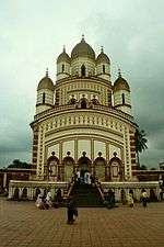 | |
|---|---|---|
| Bardhaman |
| |
| Birbhum |
| |
| Hooghly | ||
| Howrah | ||
| Jalpaiguri | ||
| Kolkata | ||
| Nadia |
| |
| North 24 Parganas |
| |
| Medinipur | ||
| Centres | ||