South Dumdum
| South Dumdum | |
|---|---|
| City | |
 South Dumdum Location in West Bengal, India | |
| Coordinates: 22°37′N 88°24′E / 22.61°N 88.40°ECoordinates: 22°37′N 88°24′E / 22.61°N 88.40°E | |
| Country |
|
| State | West Bengal |
| District | North 24 Parganas |
| Government | |
| • Chairman, Municipality | Pachu Roy |
| • Vice-Chairman, Municipality | Sujit Bose |
| Area | |
| • Total | 9.23 km2 (3.56 sq mi) |
| Population (2011) | |
| • Total | 403,316 |
| • Density | 44,000/km2 (110,000/sq mi) |
| Languages | |
| • Official | Bengali, English |
| Time zone | UTC+5:30 (IST) |
| Telephone code | 91 33 |
| Lok Sabha constituency | Dum Dum, Barasat |
| Vidhan Sabha constituency | Dum Dum, Bidhannagar, Rajarhat Gopalpur |
| Website |
sddm |
South Dumdum is a city and a municipality in Barrackpore subdivision in North 24 Parganas district in the Indian state of West Bengal. It is a part of Kolkata Urban Agglomeration.
History
Clive House at Rastraguru Avenue in Nagerbazar is mired in controversy. It is thought of as the first pucca brick and cement building in the north Kolkata area, possibly built by the Portuguese. Now, some people are saying that it was the hunting lodge of an Indian prince or noble man (and so where was the jungle?) What is definitely known is that it was used by British soldiers when they first started coming into the country and then Robert Clive took it over, renovated it, added a floor to the single-storeyed building and made it his country house (some people refer to it as his residence, which appears doubtful) around 1757-60. The house is located on a raised ground. In the otherwise flat surroundings it is even thought of as a mound or a hill. The more interesting part of the story is that “on excavation of Clive House, coins, terracotta figures, sculpture, potteries etc. and information of a Portuguese Fort were found.” The articles found could be of the Sen period but some people think that it could have links with the 2,000 years/ more older civilisation unearthed earlier at Chandraketugarh. Clive House is under the Archaeological Survey of India since 2004, but squatters inside and outside Clive House have hindered restoration work.[1][2][3][4][5][6][7]
South Dumdum municipality was established in 1870.[8]
With the partition of Bengal in 1947, "millions of refugees poured in from erstwhile East Pakistan."[9] In the initial stages bulk of the refugees were non-agriculturists. A few of them made their own arrangements, but "it was squatters who made the East Bengali refugees famous or infamous." Squatting (jabardakhal in Bengali) ranged from the forcible occupation of barracks to the collective take-over of private, government and waste land. By 1949, there were 65 refugee colonies in the Dum Dum and Panihati zone. The squatters were in a way “self-settlers” in the absence of adequate official arrangements for rehabilitation. Within a very short time the refugees (quite often with government/ administrative support) not only found a place to stay but developed a society with markets, schools, temples and sometimes even colleges, hospitals and recreational centres.[10][11]
Geography
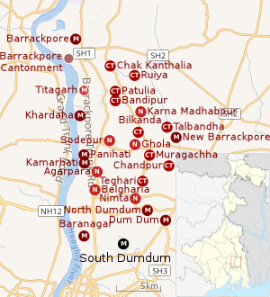 |
| Cities and towns in the southern portion of Barrackpore subdivision in North 24 Parganas district M: municipal city/ town, CT: census town, N: neighbourhood/administrative location Owing to space constraints in the small map, the actual locations in a larger map may vary slightly |
Location
South Dumdum is located at 22°37′N 88°24′E / 22.61°N 88.40°E.[12]
South Dumdum is bounded by North Dumdum (municipality) and Dum Dum (municipality) on the north, Baguiati on the east, Bidhannagar on the south, and Belgachia and Sinthee in Kolkata district and Baranagar (municipality) on the west.[13][14]
South Dum Dum consists of localities like, Nagerbazar, Bangur Avenue, Dum Dum Park, Lake Town.
96% of the population of Barrackpore subdivision (partly presented in the map alongside, all places marked on the map are linked in the full screen map) lives in urban areas. In 2011, it had a density of population of 10,967 per km2 The subdivision has 16 municipalities and 24 census towns.[15] For most of the cities/ towns information regarding density of population is available in the Infobox. Population data is not available for neighbourhoods. It is available for the entire municipal area and thereafter ward-wise.
Police station
Dum Dum police station under Barrackpore Police Commissionerate has jurisdiction over Dum Dum and South Dumdum municipal areas.[16][17]
Demographics
Population
| Population of South Dumdum | |||
|---|---|---|---|
| Census | Pop. | %± | |
| 1901 | 10,904 | — | |
| 1911 | 12,874 | 18.1% | |
| 1921 | 14,030 | 9.0% | |
| 1931 | 18,471 | 31.7% | |
| 1941 | 25,838 | 39.9% | |
| 1951 | 61,391 | 137.6% | |
| 1961 | 111,284 | 81.3% | |
| 1971 | 174,342 | 56.7% | |
| 1981 | 230,266 | 32.1% | |
| 1991 | 232,811 | 1.1% | |
| 2001 | 392,444 | 68.6% | |
| 2011 | 403,316 | 2.8% | |
| Source:[18] | |||
As per the 2011 Census of India, South Dum Dum had a total population of 403,316, of which 202,214 (50%) were males and 201,102 (50%) were females. Population below 6 years was 28,703. The total number of literates in South Dum Dum was 344,971 (92.09% of the population over 6 years).[19]
As of 2001 India census,[20] South Dumdum had a population of 392,150. Males constitute 51% of the population and females 49%. South Dumdum has an average literacy rate of 83%, higher than the national average of 59.5%: male literacy is 87%, and female literacy is 80%. In South Dumdum, 8% of the population is under 6 years of age.
Kolkata Urban Agglomeration
The following Municipalities, Census Towns and other locations in Barrackpore subdivision were part of Kolkata Urban Agglomeration in the 2011 census: Kanchrapara (M), Jetia (CT), Halisahar (M), Balibhara (CT), Naihati (M), Bhatpara (M), Kaugachhi (CT), Garshyamnagar (CT), Garulia (M), Ichhapur Defence Estate (CT), North Barrackpur (M), Barrackpur Cantonment (CB), Barrackpore (M), Jafarpur (CT), Ruiya (CT), Titagarh (M), Khardaha (M), Bandipur (CT), Panihati (M), Muragachha (CT) New Barrackpore (M), Chandpur (CT), Talbandha (CT), Patulia (CT), Kamarhati (M), Baranagar (M), South Dumdum (M), North Dumdum (M), Dum Dum (M), Noapara (CT), Babanpur (CT), Teghari (CT), Nanna (OG), Chakla (OG), Srotribati (OG) and Panpur (OG).[21]
Infrastructure
As per the District Census Handbook 2011, South Dumdum municipal city covered an area of 9.23 km2. Amongst the civic amenities it had 7,940 km of roads and both open and covered drains. Amongst the medical facilities It had 438 medicine shops. Amongst the educational facilities it had 149 primary schools, 1 middle school, 41 secondary schools and 38 senior secondary schools. Amongst the social, recreational and cultural facilities it had 1 orphanage home, 1 old age home, 1 stadium, 4 cinema/theatres, 3 auditorium/ community halls, 1 public library and 1 reading room. It had 12 bank branches.[22]
Economy
KMDA
South Dumdum municipality is included in the Kolkata Metropolitan Area for which the KMDA is the statutory planning and development authority.[23][24]
Transport
NH 12 (previously NH 34), running from Dalkhola to Bakkhali, locally popular as Jessore Road, passes through Dum Dum.[25][14] In 2012, a flyover was opened at Nagerbazar to decongest the heavy traffic on Jessore Road for airport bound traffic.[26]
Dum Dum Junction railway station, on the Sealdah-Ranaghat line, is 7 km from Sealdah railway station.[27][14] It is part of the Kolkata Suburban Railway system. Two lines branch out after Dum Dum Junction railway station – the Calcutta Chord line linking Dum Dum Junction railway station with Dankuni Junction railway station[28] and the Sealdah-Bangaon line.[29]
The first track of Kolkata Metro, the first underground metro in India, was constructed from Dum Dum to Tollyganj. It was progressively commissioned, the full length of 16.45 km being commissioned in 1995.[30] The Dum Dum metro station is located adjacent to Dum Dum Junction railway station. The extension of metro from Dum Dum to Dakshineswar was sanctioned in 2010-11. It was extended up to Noapara in 2013. The subsequent work was held up because of the encroachments on railway land. The state government has taken steps to remove the encroachment and work is expected to make progress.[31][32][33][34]
Education
The following institutions are located in Dum Dum:
- Dr. Sudhir Chandra Sur Degree Engineering College, established by the JIS Educational Initiatives at Dum Dum in 2009 offers degree, diploma and post graduate courses in engineering.[35]

- Dum Dum Krishna Kumar Hindu Academy, at Motijheel Avenue, Amarpalli, in Ward No. 9, South Dum Dum Municipality, is a boys only Bengali-medium higher secondary school. It has arrangements for teaching from Classes VI – XII. It was established in 1933.[36][37]
- Dum Dum Kishore Bharati High School, Motijheel Avenue, in Ward No. 9, South Dum Dum Municipality, is a boys only Bengali-medium higher secondary school. It has arrangements for teaching from Classes VI – XII. It was established in 1965.[38][39]
- Dum Dum Road Government-sposored High School for Girls, at Ghugudanga, is a girls only Bengali-medium higher secondary school. It was established in 1962.[40][41]
- Krishnapur Adarsha Vidyamandir, at Dum Dum Park, in Ward No. 28 in South Dum Dum Municipality, is a boys only Bengali-medium higher secondary school. It has facilities for teaching in Classes VI to XII. It was established in 1954.[42][43]
- Dum Dum Prachya Banimandir for Boys at Seth Bagan is a boys only higher secondary school.[44]
- Dum Dum Prachya Banimandir for Girls at Seth Bagan is a girls only higher secondary school.[44]
- Dum Dum Sri Aurabinda Vidyamandir in Kshudiram Colony is a co-educational higher secondary school.[45]
- Sahid Rameswar Vidyamandir, Jessore Road, Amarpalli, is a co-educational, higher secondary school.[46]
- Seth Bagan Adarsha Vidyamandir is a co-educational, higher secondary school.[47]
- Christ Church Girls High School, Jessore Road, is a Bengali-medium, girls only school preparing students for madhyamik and higher secondary examination of the West Bengal boards. Established in 1882, it has arrangements for teaching from Infant to Class XII. Admission for Primary section starts around December. It has hostel facilities.[48][49]
- St. Mary's Orphanage & Day School, Kolkata, was initially set up by Christian Brothers from Ireland at Murgihata in Calcutta in 1848 and shifted to Dum Dum Road in 1947. It is a boys only institution and prepares students for the ICSE and ISC examinations.[50][51]
- Howard Memorial English School, in Ward No. 22, South Dum Dum Municipality, is an English-medium co-educational school leading to ICSE Board examinations. It was established in 1963.[52]
See also - North Dumdum and Dum Dum for more schools in the Dum Dum area
Healthcare
South Dumdum Maternity Home functions with 15 beds.[53]
ILS Hospital, near Nagerbazar Flyover, is a 120-bed multi-speciality hospital. It offers 14 surgical facilities and 2 speciality clinics – bariatric (weight-loss) and diabetic.[54][55]
References
- ↑ "Ordnance Factory Dum Dum". Dum Dum Story. Indian Ordnance Factories. Retrieved 29 July 2018.
- ↑ "Heritage of Kolkata – Clive House – under dilapidation". Asim Kumar 2011. Retrieved 29 July 2018.
- ↑ "District Census Handbook North Twenty Four Parganas, Census of India 2011, Series 20, Part XII A" (PDF). Places of religious importance, Page 123. Directorate of Census Operations, West Bengal. Retrieved 29 July 2018.
- ↑ "Old house on the hill". The Telegraph, 23 May 2003. Retrieved 29 July 2018.
- ↑ "The two faces of Clive House in Dum Dum – Squatters inside or outside building still impeding Archaeulogical Survey's restoration project". The Telegraph, 24 January 2006. Retrieved 29 July 2018.
- ↑ "Dum Dum mound may rewrite Kolkata history". The Times of India, 23 November 2014. Retrieved 29 July 2018.
- ↑ "Clive of India's House at Dum Dum, Calcutta". Vivat Heritage, 2012. Retrieved 29 July 2018.
- ↑ "South Dum Dum Municipality". Barrackpore administration. Retrieved 28 July 2018.
- ↑ Chatterjee, Monideep, "Town Planning in Calcutta: Past, Present and Future", in "Calcutta, The Living City" Vol II, Edited by Sukanta Chaudhuri, Page 142, First published 1990, 2005 edition, ISBN 019 563697
- ↑ Chatterjee, Nilanjana, "The East Bengal Refugees: A Lesson in Survival", in "Calcutta, The Living City" Vol II, Edited by Sukanta Chaudhuri, Pages 72-75, First published 1990, 2005 edition, ISBN 019 563697
- ↑ Sen, Uditi. "The Myths Refugees Live By Memory and History of the Making of Bengali Refugee Identity". 2014, Page 48. Modern Asian Studies, 48, doi:10.1017/S0026749X12000613. Retrieved 5 March 2018.
- ↑ "Yahoo maps of South Dumdum". Yahoo maps. Retrieved 2008-11-29.
- ↑ "District Census Handbook North Twenty Four Parganas, Census of India 2011, Series 20, Part XII A" (PDF). Map of Barrackpore II CD Block on Page 379. Directorate of Census Operations, West Bengal. Retrieved 23 July 2018.
- 1 2 3 Google maps
- ↑ "District Statistical Handbook". North 24 Parganas 2013, Tables 2.1, 2.2, 2.4b. Department of Statistics and Programme Implementation, Government of West Bengal. Retrieved 2 May 2018.
- ↑ "District Statistical Handbook". North 24 Parganas 2013, Table 2.1. Department of Statistics and Programme Implementation, Government of West Bengal. Retrieved 11 June 2018.
- ↑ "Barrackpore Police Commissionerate". List of Police Stations with telephone numbers. West Bengal Police. Retrieved 11 June 2018.
- ↑ "District Census Handbook North Twenty Four Parganas, Census of India 2011, Series 20, Part XII A" (PDF). Section II Town Directory, Pages 781-783 Statement I: Growth History, Pages 799-803. Directorate of Census Operations V, West Bengal. Retrieved 11 June 2018.
- ↑ "2011 Census – Primary Census Abstract Data Tables". West Bengal – District-wise. Registrar General and Census Commissioner, India. Retrieved 7 June 2018.
- ↑ "Census of India 2001: Data from the 2001 Census, including cities, villages and towns (Provisional)". Census Commission of India. Archived from the original on 2004-06-16. Retrieved 2008-11-01.
- ↑ "Provisional Population Totals, Census of India 2011" (PDF). Constituents of Urban Agglomeration Having Population Above 1 Lakh. Census of India 2011. Retrieved 7 June 2018.
- ↑ "District Census Handbook North Twenty Four Parganas, Census of India 2011, Series 20, Part XII A" (PDF). Section II Town Directory, Pages 781-783 Statement I: Growth History, Pages 799-803; Statement II: Physical Aspects and Location of Towns, Pages 791-794; Statement III: Civic and other Amenities, Pages 795-796; Statement IV: Medical Facilities 2009, Pages 803-805 Section: Educational, Recreational and Cultural Facilities. Directorate of Census Operations V, West Bengal. Retrieved 31 May 2018.
- ↑ "Kolkata Metropolitan Development Authoity, Annual Report 2010-11". 1/1 Kolkata Metropolitan Area Map. KMDA. Retrieved 7 June 2018.
- ↑ "Kolkata Metropolitan Development Authority, Annual Report 2010-11". 1 / 2 Role of KMDA. KMDA. Retrieved 7 June 2018.
- ↑ "Rationalisation of Numbering Systems of National Highways" (PDF). New Delhi: Department of Road Transport and Highways. Retrieved 16 September 2016.
- ↑ "CM inaugurates Nagerbazar flyover". Indian Express. 25 March 2012. Retrieved 16 March 2013.
- ↑ "31311 Sealdah-Kalyani Simanta Local". Time Table. indiarailinfo. Retrieved 12 June 2018.
- ↑ "32211 Sealdah-Dankuni local". Time Table. Inidia Rail Info. Retrieved 23 July 2018.
- ↑ "33811 Seldah Bangaon Local". Time Table. indiarailinfo. Retrieved 26 May 2018.
- ↑ "Welocme to Metro Railway". Metro Railway, Kolkata. Retrieved 29 July 2018.
- ↑ "Road Ahead… Projects Sanctioned". Dakshineswar-Dum Dum-Barrackpore Metro Extension. Metro Railway, Kolkata. Retrieved 24 July 2018.
- ↑ "Dakshineswar Metro by 2019 Pujas: says Chairman, Railway Board". Rail News 6 March 2018. Retrieved 24 July 2018.
- ↑ "Land cloud over Dakshineswar Metro set to lift". The Telegraph, 13 October 2017. Retrieved 24 July 2018.
- ↑ "Dakshineswar won't feature in Metro map by December 2019". The Times of India, 14 October 2017. Retrieved 24 July 2018.
- ↑ "Dr. Sudhir Chandra Sur Degree Engineering College". DSEC. Retrieved 20 July 2018.
- ↑ "Dum Dum K.K. Hindu Academy [H.S.] Govt Sponsored". DDKKHA. Retrieved 29 July 2018.
- ↑ "Dum Dum KK Hindu Academy School". ICBSE. Retrieved 29 July 2018.
- ↑ "Dum Dum Kishore Bharati High S School". ICBSE. Retrieved 29 July 2018.
- ↑ "Dum Dum Kishore Bharati High School". School Connects. Retrieved 29 July 2018.
- ↑ "Dum Dum Road Govt-sponsored High School for Girls - HS". Find Glocal. Retrieved 29 July 2018.
- ↑ "Government-sposored Highh School for girls". Sulekha.com. Retrieved 29 July 2018.
- ↑ "Krishnapur Adarsha Vidyamandir School". ICBSE. Retrieved 29 July 2018.
- ↑ "Krishnapur Adarsha Vidyamandir". Target Study. Retrieved 29 July 2018.
- 1 2 "West Bengal Council of Higher Secondary Education". Exam Venue. WBCHSE. Retrieved 29 July 2018.
- ↑ "West Bengal Council of Higher Secondary Education". Exam Venue. WBCHSE. Retrieved 29 July 2018.
- ↑ "Sahid Rameswar Vidyamandir". WBCHSE. Retrieved 29 July 2018.
- ↑ "West Bengal Council of Higher Secondary Education". WBCHSE. Retrieved 29 July 2018.
- ↑ "Christ Church Girls High School". Schools of Kolkata. Retrieved 29 July 2018.
- ↑ "Christ Church Girls High School". Sulekha.com. Retrieved 29 July 2018.
- ↑ "St. Mary's Orphanage & Day School". ICBSE. Retrieved 29 July 2018.
- ↑ "Dum Dum St. Mary's Ex-Students' Association". DDSSA. Retrieved 29 July 2018.
- ↑ "Howard Memorial English School". Schools World. Retrieved 29 July 2018.
- ↑ "Health & Family Welfare Department". Health Statistics. Government of West Bengal. Retrieved 25 July 2018.
- ↑ "Your health, our happiness". ILS Hospitals. Retrieved 24 July 2018.
- ↑ "ILS Hospitals now opens in Dum Dum". The Telegraph, 31 May 2013. Retrieved 24 July 2018.