Polba
| Polba | |
|---|---|
| Village | |
 Polba Location in West Bengal, India  Polba Polba (India) | |
| Coordinates: 22°57′41″N 88°18′24″E / 22.9615°N 88.3066°ECoordinates: 22°57′41″N 88°18′24″E / 22.9615°N 88.3066°E | |
| Country |
|
| State | West Bengal |
| District | Hooghly |
| Elevation | 15 m (49 ft) |
| Population (2011) | |
| • Total | 6,626 |
| Languages | |
| • Official | Bengali, English |
| Time zone | UTC+5:30 (IST) |
| PIN | 712514 (Polba) |
| Telephone/STD code | 03213 |
| Lok Sabha constituency | Hooghly |
| Vidhan Sabha constituency | Chunchura |
| Website |
hooghly |
Polba is a village in Polba Dadpur CD Block in Chinsurah subdivision of Hooghly district in the state of West Bengal, India.
Geography
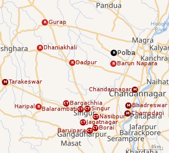 |
| Cities and towns in the Chandannagore subdivision and Polba Dadpur and Dhaniakhali CD Blocks of Chinsurah subdivision in Hooghly district M: municipal corporation/ municipal city/ town, CT: census town, R: rural/ urban centre, Owing to space constraints in the small map, the actual locations in a larger map may vary slightly |
Location
The area is composed of flat alluvial plains that form a part of the Gangetic Delta.[1]
Police station
Polba police station has jurisdiction over a part of Polba Dadpur CD Block.[2][3]
Urbanisation
In Chandannagore subdivision 58.52% of the population is rural and the urban population is 41.48%. Chandannagore subdivision has 1 municipal corporation, 3 municipalities and 7 census towns. The single municipal corporation is Chandernagore Municipal Corporation. The municipalities are Tarakeswar Municipality, Bhadreswar Municipality and Champdany Municipality.[4]Of the three CD Blocks in Chandannagore subdivision, Tarakeswar CD Block is wholly rural, Haripal CD Block is predominantly rural with just 1 census town, and Singur CD Block is slightly less rural with 6 census towns. Polba Dadpur and Dhaniakhali CD Blocks of Chinsurah subdivision (included in the map alongside) are wholly rural.[5]The municipal areas are industrialised. All places marked in the map are linked in the larger full screen map.
Demographics
As per the 2011 Census of India, Polba had a total population of 6,626 of which 3,333 (50%) were males and 3,293 (50%) were females. Population below 6 years was 628. The total number of literates in Polba was 4,643 (77.41% of the population over 6 years).[6]
Transport
Polba is on Pandua-Bandel Road. Mogra-Polba Road and Polba-Alinagar Road also meet at Polba.[7]
Education
Polba Mahavidyalaya, a general degree college, was established at Polba in 2005. It is affiliated with the University of Burdwan and offers honours courses in Bengali, English, Sanskrit, history and philosophy.[8][9]
Healthcare
There is a rural hospital (with 30 beds) at Polba.[10]
References
- ↑ "District Census Handbook: Hugli, Series-20, Part XIIA" (PDF). Physiography, Page 17-24. Directorate of Census Operations, West Bengal, 2011. Retrieved 28 September 2018.
- ↑ "District Statistical Handbook 2014 Hooghly". Tables 2.1, 2.2,. Department of Statistics and Programme Implementation, Government of West Bengal. Retrieved 3 October 2018.
- ↑ "Hooghly District Police". West Bengal Police. Retrieved 20 June 2017.
- ↑ "District Statistical Handbook 2014 Hooghly". Table 2.1, 2.2, 2.4(a). Department of Statistics and Programme Implementation, Government of West Bengal. Retrieved 27 September 2018.
- ↑ "C.D. Block Wise Primary Census Abstract Data(PCA)". 2011 census: West Bengal – District-wise CD Blocks. Registrar General and Census Commissioner, India. Retrieved 27 September 2018.
- ↑ "2011 Census – Primary Census Abstract Data Tables". West Bengal – District-wise. Registrar General and Census Commissioner, India. Retrieved 20 June 2017.
- ↑ Google maps
- ↑ "Polba Mahavidyalaya". PM. Retrieved 30 June 2017.
- ↑ "Polba Mahavidyalaya". College Admission. Retrieved 30 June 2017.
- ↑ "Health & Family Welfare Department". Health Statistics. Government of West Bengal. Retrieved 15 July 2017.