Garulia
| Garulia | |
|---|---|
| Town | |
 Garulia Location in West Bengal, India | |
| Coordinates: 22°49′N 88°22′E / 22.82°N 88.37°ECoordinates: 22°49′N 88°22′E / 22.82°N 88.37°E | |
| Country |
|
| State | West Bengal |
| District | North 24 Parganas |
| Government | |
| • Municipality Chairman | Sunil Singh [1] |
| Area | |
| • Total | 6.47 km2 (2.50 sq mi) |
| Elevation | 13 m (43 ft) |
| Population (2011) | |
| • Total | 85,336 |
| • Density | 13,000/km2 (34,000/sq mi) |
| Languages | |
| • Official | Bengali, English |
| Time zone | UTC+5:30 (IST) |
| PIN | 743133 |
| Telephone code | 91 33 |
| ISO 3166 code | IN-WB |
| Lok Sabha constituency | Barrackpore |
| Vidhan Sabha constituency | Noapara |
| Website |
north24parganas |
Garulia is a town with a municipality in Barrackpore subdivision[2] of North 24 Parganas district in the state of West Bengal, India.
History
Garulia municipality was established in 1869.[3]
Geography
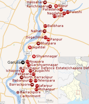 |
| Cities and towns in the northern portion of Barrackpore subdivision in North 24 Parganas district M: municipal city/ town, CT: census town, N: neighbourhood, OG: outgrowth Owing to space constraints in the small map, the actual locations in a larger map may vary slightly |
Location
Garulia is located at 22°49′N 88°22′E / 22.82°N 88.37°E.[4] It has an average elevation of 13 metres (43 ft).
Cool air blows in winter and very heavy rain falls in summer. Inhabitants are Hindus, Muslims and others. The Bengalis are refugees from Bangladesh and local Indian Bengalis. There are ferry services which continue until midnight.
Garulia is bounded by Bhatpara on the north, Garshyamnagar and Noapara on the east, North Barrackpur on the south and the Hooghly on the west.[5]
96% of the population of Barrackpore subdivision (partly presented in the map alongside; all places marked on the map are linked in the full-screen map) lives in urban areas. In 2011, it had a density of population of 10,967 per km2 The subdivision has 16 municipalities and 24 census towns.[6]
For most of the cities/ towns information regarding density of population is available in the Infobox. Population data is not available for neighbourhoods. It is available for the entire municipal area and thereafter ward-wise.
Police station
Noapara police station under Barrackpore Police Commissionerate has jurisdiction over Garulia and North Barrackpur municipal areas.[7][8]
Post Office
Garulia has a delivery sub post office, with PIN 743133 in the North Presidency Division of North 24 Parganas district in Calcutta region. The only other post offices with the same PIN is Pinkal.[9]
Demographics
Population
| Population of Garulia | |||
|---|---|---|---|
| Census | Pop. | %± | |
| 1901 | 7,375 | — | |
| 1911 | 11,580 | 57.0% | |
| 1921 | 13,096 | 13.1% | |
| 1931 | 14,033 | 7.2% | |
| 1941 | 20,150 | 43.6% | |
| 1951 | 28,304 | 40.5% | |
| 1961 | 29,041 | 2.6% | |
| 1971 | 44,271 | 52.4% | |
| 1981 | 57,061 | 28.9% | |
| 1991 | 80,918 | 41.8% | |
| 2001 | 79,926 | -1.2% | |
| 2011 | 85,336 | 6.8% | |
| Source:[10] | |||
As per the 2011 Census of India, Garulia had a total population of 85,336, of which 44,825 (53%) were males and 40,511 (47%) were females. Population below 6 years was 7,247. The total number of literates in Garulia was 67,835 (86.87% of the population over 6 years).[11]
As of 2001 India census,[12] Garulia had a population of 76,309. Males constitute 53% of the population and females 47%. Garulia has an average literacy rate of 73%, higher than the national average of 59.5%: male literacy is 79%, and female literacy is 67%. In Garulia, 10% of the population is under six years of age.But now some figure has been changed.
Kolkata Urban Agglomeration
The following Municipalities, Census Towns and other locations in Barrackpore subdivision were part of Kolkata Urban Agglomeration in the 2011 census: Kanchrapara (M), Jetia (CT), Halisahar (M), Balibhara (CT), Naihati (M), Bhatpara (M), Kaugachhi (CT), Garshyamnagar (CT), Garulia (M), Ichhapur Defence Estate (CT), North Barrackpur (M), Barrackpur Cantonment (CB), Barrackpore (M), Jafarpur (CT), Ruiya (CT), Titagarh (M), Khardaha (M), Bandipur (CT), Panihati (M), Muragachha (CT) New Barrackpore (M), Chandpur (CT), Talbandha (CT), Patulia (CT), Kamarhati (M), Baranagar (M), South Dumdum (M), North Dumdum (M), Dum Dum (M), Noapara (CT), Babanpur (CT), Teghari (CT), Nanna (OG), Chakla (OG) Srotribati (OG) and Panpur (OG).[13]
Infrastructure
As per the District Census Handbook 2011, Garulia municipal town covered an area of 6.47 km2. Amongst the civic amenities it had 51 km of roads and both open and closed drains. Amongst the educational facilities It had 28 primary schools, 5 secondary schools, 2 senior secondary schools and 5 non-formal education centres. Amongst the social, recreational and cultural facilities it had 1 public library and 3 reading rooms. Amongst the commodities manufactured were cotton, jute and rakhi. It had 3 bank branches.[14]
According to the Barrackpore administration, amongst the educational facilities in Garulia municipality there are 20 primary schools and 6 higher secondary schools. Amongst the other facilities there are 3 nursing homes, 3 markets, 2 ferry ghats (Babughat and Kangalighat), 1 burning ghat (Ratneswar Burning Ghat) and 2 Muslim burial grounds.7,000 houses have water connection and there are around 150 street taps.[3]
Economy
Industry
Big mills in Garulia are Sree Gouri Sankar Jute Mill Pvt. Ltd. and Sree Annapurna Cotton Mills and Industries.[3]
KMDA
Garulia municipality is included in the Kolkata Metropolitan Area for which the KMDA is the statutory planning and development authority.[15][16]
Healthcare
North 24 Parganas district has been identified as one of the areas where ground water is affected by arsenic contamination.[17]
Culture
Garulia has several temples and mosques. Sitla Mandir is one of the oldest temples in Garulia. Garulia Jama Masjid is biggest mosque and also beautiful mosque of Garulia. There is the Murali Manohar Mandir in Garulia Bazar. There also are many majars where both Hindus and Muslims come and pray.
References
- ↑ Garulia Municipality
- ↑ District-wise list of statutory towns Archived September 27, 2007, at the Wayback Machine.
- 1 2 3 "Garulia Municipality". Barrackpore administration. Retrieved 24 June 2018.
- ↑ Falling Rain Genomics, Inc - Garulia
- ↑ "District Census Handbook North Twenty Four Parganas, Census of India 2011, Series 20, Part XII A" (PDF). Map of Barrackpore I CD Block on Page 365. Directorate of Census Operations, West Bengal. Retrieved 21 June 2018.
- ↑ "District Statistical Handbook". North 24 Parganas 2013, Tables 2.1, 2.2, 2.4b. Department of Statistics and Programme Implementation, Government of West Bengal. Retrieved 2 May 2018.
- ↑ "District Statistical Handbook". North 24 Parganas 2013, Tables 2.1, 2.2, 2.4b. Department of Statistics and Programme Implementation, Government of West Bengal. Retrieved 11 June 2018.
- ↑ "Barrackpore Police Commissionerate". List of Police Stations with telephone numbers. West Bengal Police. Retrieved 11 June 2018.
- ↑ "Garulia PIN Code". pincodezip.in. Retrieved 11 July 2018.
- ↑ "District Census Handbook North Twenty Four Parganas, Census of India 2011, Series 20, Part XII A" (PDF). Section II Town Directory, Pages 781-783 Statement I: Growth History, Pages 799-803. Directorate of Census Operations V, West Bengal. Retrieved 11 June 2018.
- ↑ "2011 Census – Primary Census Abstract Data Tables". West Bengal – District-wise. Registrar General and Census Commissioner, India. Retrieved 7 June 2018.
- ↑ "Census of India 2001: Data from the 2001 Census, including cities, villages and towns (Provisional)". Census Commission of India. Archived from the original on 2004-06-16. Retrieved 2008-11-01.
- ↑ "Provisional Population Totals, Census of India 2011" (PDF). Constituents of Urban Agglomeration Having Population Above 1 Lakh. Census of India 2011. Retrieved 7 June 2018.
- ↑ "District Census Handbook North Twenty Four Parganas, Census of India 2011, Series 20, Part XII A" (PDF). Section II Town Directory, Pages 781-783 Statement I: Growth History, Pages 799-803; Statement II: Physical Aspects and Location of Towns, Pages 791-794; Statement III: Civic and other Amenities, Pages 795-796; Statement IV: Medical Facilities 2009, Pages 803-805 Section: Educational, Recreational and Cultural Facilities. Directorate of Census Operations V, West Bengal. Retrieved 31 May 2018.
- ↑ "Kolkata Metropolitan Development Authoity, Annual Report 2010-11". 1/1 Kolkata Metropolitan Area Map. KMDA. Retrieved 7 June 2018.
- ↑ "Kolkata Metropolitan Development Authority, Annual Report 2010-11". 1 / 2 Role of KMDA. KMDA. Retrieved 7 June 2018.
- ↑ "Groundwater Arsenic contamination in West Bengal-India (19 years study )". Groundwater arsenic contamination status of North 24-Parganas district, one of the nine arsenic affected districts of West Bengal-India. SOES. Retrieved 2007-08-24.