Durgapur
| Durgapur | |
|---|---|
| Metropolitan City / Urban Agglomeration | |
.jpg) | |
| Nickname(s): Ruhr of India | |
 Durgapur Location in West Bengal, India | |
| Coordinates: 23°33′N 87°19′E / 23.55°N 87.32°ECoordinates: 23°33′N 87°19′E / 23.55°N 87.32°E | |
| Country | India |
| State | West Bengal |
| District | Paschim Bardhaman |
| Established | Late 1950s |
| Founded by | Dr. Bidhan Chandra Roy (former chief minister of West Bengal) |
| Named for | Durgamohan Chattopadhyay, former Zamindar of Sagarbhanga |
| Government | |
| • Type | Municipality |
| • Body | Durgapur Municipal Corporation (DMC) |
| • Mayor | Dilip Agasty |
| • Commissioner of Police (CP) | Vineet Kumar Goyal, IPS (Asansol-Durgapur Police Commissionerate) |
| Area | |
| • Total | 154.20 km2 (59.54 sq mi) |
| Elevation | 65 m (213 ft) |
| Population (2011) | |
| • Total | 1,080,990 |
| • Density | 7,000/km2 (18,000/sq mi) |
| Demonym(s) | Durgapurbashi, Durgapurians |
| Languages | |
| • Official | Bengali, English, |
| Time zone | UTC+5:30 (IST) |
| PIN | 713 2xx [713 201-713 216(city proper);713 217 & 713 219 (suburbs)] |
| Telephone code | +91 343 |
| Vehicle registration | WB-39 / WB-40 |
| Lok Sabha constituency | Bardhaman-Durgapur (MP - Mamtaz Sanghamita - AITC ) |
| Vidhan Sabha constituency |
Durgapur Purba (MLA - Santosh Debray - CPI(M)), Durgapur Paschim (MLA - Biswanath Pariyal (CPIM & INC) |
| Climate | Aw |
| Website |
durgapurmunicipalcorporation |
Durgapur is a Tier-II city in Paschim Bardhaman district, in the state of West Bengal, India. Durgapur is the 3rd largest urban agglomeration after Kolkata and Asansol in West Bengal and happens to be the 2nd planned city in India after Chandigarh and has the only operational dry (inland) port in the Eastern part of India. Durgapur was planned by two American Architects- Joseph Allen Stein and Benjamin Polk in 1955. It is the only city in Eastern India to have an operational dry dock.
Geography
Durgapur is located at 23°29′N 87°19′E / 23.48°N 87.32°E.[1] It has an average elevation of 65 metres (213 ft).
Durgapur is in the Paschim Bardhaman district of West Bengal, on the bank of the Damodar River, just before it enters the alluvial plains of Bengal. The topography is undulating. The coal-bearing area of the Raniganj coalfields lies just beyond Durgapur; some parts intrude into the area. The area was deeply forested till recent times, and some streaks of the original Sal and eucalyptus forests can still be seen.
Durgapur subdivision is surrounded by Asansol Sadar subdivision on the west, Purba Bardhaman district on the east, Bankura district across the Damodar in the south, and Birbhum district across the Ajay River to the north.

Police stations
Durgapur police station, located on Aurobindo Avenue, Durgapur Steel Township, has jurisdiction over parts of Andal CD Block. The area covered is 80 km2 and the population covered is 292,841.[2][3]
Coke Oven police station, located near Durgapur railway station, has jurisdiction over parts of Durgapur municipal corporation. The area covered is 49 km2 and the population covered is 136,181.[2][3]
New Township police station, located in MAMC township, has jurisdiction over parts of Durgapur municipal corporation and Faridpur Durgapur CD Block. The area covered is 23 km2 and the population covered is 160,411.[2][3]
Demographics
In the 2011 census, Durgapur M.Corp had a population of 566,517 out of which 294,255 were males and 272,262 were females. The 0–6 years population was 51,930. Effective literacy rate for the 7+ population was 87.70.[4]
Religion
According to Census of India 2011, Hinduism is the predominant religion in this city, followed by Islam, Christianity, Sikhism, Buddhism, Jainism and others. Out of 5,66,517 people living in Durgapur (Municipal Corporation); 5,19,122 are Hindus (91.63%), 35,923 are Muslims (6.34%), 1889 are Christians (0.36%), 2346 are Sikhs (0.44%), 513 are Buddhists, 382 are Jains, 906 are other religions and 5436 (1.04%) did not state their religion.[5]
Transport
Road
Durgapur is the preferred gateway to the districts of Bankura, Birbhum ( Bolpur, rampurhat, Suri ), and Purulia, which are not that well connected. NH 19 (old numbering: NH 2) passes through the city jurisdiction and SH 9 originates from Muchipara in the city. NH 14 (old numbering NH 60) passes through the north-western suburb of Pandabeswar and finally passes through Raniganj and heads away towards Orissa. It happens to be one of the very few cities that have an Asian Highway (AH) passing directly through the city jurisdiction. The AH1 links Japan with Turkey, through Korea, China, Vietnam, Cambodia, Thailand, Myanmar, India, Bangladesh, Pakistan, Afghanistan, and Iran.
Durgapur has bus termini at Benachiti-I, Benachiti-II (commonly referred as Prantika), City Center, and Station Morh. One bus terminus is coming up at Nadiha, but only for inter-city commuting.
Intra-city And Intercity Road Transport
Within the city private mini-buses operate from Prantika to Station terminus, via different routes through the city. Some of them operate to other termini from Prantika, like Nadiha, Madhaipur, Kasba, Sillyaghat, etc.
Auto-rickshaws ply between City Center, Benachity, Railway Station and other parts of the city in a number of routes. Cycle-rickshaws can be used to travel smaller distances. Pre-paid taxis are available in the city from Station and City Center Terminus. Additionally, cab and auto-rickshaw services for the city are offered online.
Only one Bus (Abhishek) available for Kalyani-Bansberia which departs from Benachity everyday at 4:40am and From Kalyani - 10am everyday. It touches Mogra, Memari, Shaktigarh, Burdwan Nababhaat Uttara Bus stand, Panagarh, Durgapur Muchipara.
SBSTC, NBSTC, Shyamoli Paribahan Buses are available from City Centre, Durgapur for Kolkata, Karunamoyee, Dharmatala, Habra, Barasat, Dumdum Airport, Malda Town, Siliguri. For exact fare and Time Table please contact with those aforesaid Bus Companies.
Air
The nearest domestic airport is Kazi Nazrul Islam Airport. The airport is roughly 15 kilometres from Durgapur's City Centre. It is India's first private-sector Greenfield airport. It is located in a place called Andal.[6]
An air force station at Panagarh, (16.3 km from Durgapur City Centre) belonging to the Indian Air Force is used as a base for a C-130J Hercules squadronal.[7]
Climate
| Durgapur | ||||||||||||||||||||||||||||||||||||||||||||||||||||||||||||
|---|---|---|---|---|---|---|---|---|---|---|---|---|---|---|---|---|---|---|---|---|---|---|---|---|---|---|---|---|---|---|---|---|---|---|---|---|---|---|---|---|---|---|---|---|---|---|---|---|---|---|---|---|---|---|---|---|---|---|---|---|
| Climate chart (explanation) | ||||||||||||||||||||||||||||||||||||||||||||||||||||||||||||
| ||||||||||||||||||||||||||||||||||||||||||||||||||||||||||||
| ||||||||||||||||||||||||||||||||||||||||||||||||||||||||||||
Durgapur experiences a somewhat transitional climate between the tropical wet and dry climate of Kolkata and the more humid subtropical climate further north. Summers are extremely hot and dry, lasting from March to the middle of June, with average daily temperatures near 32 °C. They are followed by the monsoon season with heavy precipitation and somewhat lower temperatures. Durgapur receives most of its annual rainfall of around 52 inches during this season. The monsoon is followed by a mild, dry winter from November to January. Temperatures are quite moderate, with average daily temperatures near 20 °C. There is a short autumn at the end of October and a short spring in February, both of which have relatively moderate temperatures of around 25 °C.
Industrialisation
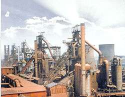
Durgapur is by far the most industrialised city in eastern India and the second planned city in India. It started with the first prime minister of independent India, Jawaharlal Nehru. His dream of transforming the backward agricultural country into an industrially advanced nation was picked up in West Bengal by Dr. B.C. Roy. At the earlier stages for the selection of a proper site for a new industrial township, Jnananjan Niyogi, a great business organiser and planner, was involved. The modernist American architect Joseph Allen Stein, invited to head the newly formed Department of Architecture and Planning at the Bengal Engineering College in Calcutta, plunged into a major project as soon as he reached India in 1952 – the designing of Durgapur city with Benjamin Polk, another American architect already living in Calcutta. Thereafter it was the task of local leaders such as Ananda Gopal Mukherjee and bureaucrats such as K.K. Sen to get Durgapur going.
Before independence, only one small refractory plant of the Martin Burn group was located at Durgapur: the abandoned chimney is visible near the station. Damodar Valley Corporation constructed Durgapur Barrage in 1955 and shortly followed with the Durgapur Thermal Power Station.
There was a massive follow up – Durgapur Steel Plant (commissioned 1960), Alloy Steels Plant (commissioned 1965), Durgapur Projects Ltd. (established 1961), Mining and Allied Machinery Corporation, ACC-Vickers Babcock (later ACC-Babcock and Alstom Power Boilers Ltd, now GE Power India Ltd.), Hindustan Fertiliser Corporation, Philips Carbon Black Ltd., Sankey Wheels (a unit of GKW), Bharat Ophthalmic Glass Ltd, Durgapur Cement Ltd. (now Birla Cement) (established 1975), Graphite India Ltd. (established 1967), Durgapur Chemicals Ltd. (DCL) was incorporated on 31 July 1963, Ispat Forgings and many others, large and small.
Administrative changes
Durgapur is a new industrial city. The administrative setup came in stages. Once the British settled down to ruling the country in the nineteenth century, they started effecting administrative changes. In 1837, when Bankura district was formed, Durgapur area was part of it. In 1847, Ranigunj subdivision was formed with three police stations – Ranigunj, Kanksa and Neamatpur - and it was made a part of Bardhaman district. In 1906, the subdivisional headquarters was shifted to Burdwan and the subdivision renamed accordingly. In 1910, the police stations in Asansol subdivision were Asansol, Ranigunj, Kanksa, Faridpur and Barakar. On 14 April 1968, Durgapur subdivision was carved out of Asansol subdivision. After TMC Government came to power in West Bengal in 2011, the Asansol Durgapur Police Commissionerate was formed by the State Government in order to improve the law and order situation in the Asansol -Durgapur belt and to curb the menace of illegal Coal Smuggling
Education
Colleges

Durgapur is home to National Institute of Technology, Durgapur,[9] an autonomous institution in eastern India of national importance. It is one of the 31 N.I.T.s in the country. N.I.T. Durgapur is one of the 8 old Regional Engineering Colleges established in 1956.
Durgapur Government College, India, is the only government college not only in the home district of Burdwan, but also in the neighbouring districts of Bankura, Purulia and Birbhum. It was established on 15 September 1970 and was affiliated to the University of Burdwan. Now it is affiliated to Kazi Nazrul University. It is funded and administered by the Government of West Bengal. Direct administrative control lies with the Director of Public Instruction, Higher Education Directorate, Government of West Bengal.
The Central Mechanical Engineering Research Institute (also known as CSIR-CMERI Durgapur or CMERI Durgapur) is a public engineering research and development institution in Durgapur, West Bengal, India. It is a constituent laboratory of the Indian Council of Scientific and Industrial Research (CSIR).[10] The institute is the only mechanical engineering research and development institution in India, dedicated to work in the mechanical and allied engineering disciplines.[11]
The National Power Training Institute (Also known as NPTI(ER) and formerly known as PETS, Durgapur) is an institute under Ministry of Power, Government of India. The Institute offers post graduate education in the field of power plants and also offers B. Tech. in Power Engineering. This institute is also associated with several industrial bodies for imparting training to plant personnel.[12]
Durgapur Institute of Advanced Technology and Management (DIATM), B.C. Roy Engineering College and the Bengal College of Engineering and Technology in Durgapur, West Bengal, India offers degree engineering courses,NSHM Faculty of Engineering and Technology, Durgapur which are affiliated to West Bengal University of Technology (WBUT). NIM Durgapur School of Hotel Management, IQ City Medical college and Hospital, Shree Ramkrishna Inst of Medical Science and Hospital (SANAKA educational trust), Swami Vivekananda School of Diploma (SANAKA educational Trust), SETGOI Institute of engineering and Industrial Technology, Gouri Devi medical college and hospital, many polytechnic college also there, New Horizon Inst of Technology, SANAKA educational Trust(R Engineering and polytechnic), NSHM knowledge campus Durgapur offers multidisciplinary courses like engineering,Hotel Management, Ophthalmology, Polytechnic, Business.Durgapur Govt College, Durgapur Women's college, MMC College, are general degree colleges affiliated to Kazi Nazul University.
Schools
Durgapur houses a large number of government aided and public schools in addition to two Kendriya Vidyalaya and Jawahar Navodaya Vidyalaya (under the Government of India). The most renowned private schools are St. Xavier's School; St. Michael's School; Bidhan School ;St. Peter's School; Delhi Public School; Carmel Convent High School, Fuljhore;DPL Boys' School, DPL Girls' School, Carmel School, Durgapur Steel Township; Aurobinda Vidya Mandir (D.H.B Road); Amrita Vidyalayam; D.A.V Model School; Pranavananda Vidya Mandir; Durgapur Ispat Vidyalaya; Hem Sheela Model School; Bidhan School; Bidhan Chandra Institution for Boys and Bidhan Chandra Institution for Girls (both imparting Higher Secondary education only); Narayana School; Amrai High School; R.P Vivekananda Vidyapith; Durgapur Tarak Nath High School; Techno India Group Public School,Career Sabish Pre-School, Durgapur Public School; Guru Teg Bahadur Public School; MAMC Modern High School and Assembly of God Church School. Besides, there are several other private schools which have achieved many laurels over the years.
Sports facilities
- Nehru Stadium is the biggest sports stadium in the city. It has a huge football ground, basketball and volleyball courts, athletic tracks, modern fully equipped gymnasium etc. It is managed by Durgapur Steel Plant Authority.
- ASP Stadium is another sporting centre with a large ground, with all facilities for cricket, football, gymnastics, etc. It is managed by the Alloy Steel Plant Authority.
- Shahid Bhagat Singh Stadium is a newly developed stadium, which is run by the Durgapur Municipal Corporation. Its football ground is one of the best in West Bengal. Teams like Mohun Bagan A.C. conduct their pre-season training camps here.
- Sidhu Kanu Indoor Stadium houses many sporting organisation and sporting association of Burdwan district, including Durgapur Sub-divisional Women's Sports Association, School Sports Association-Durgapur Sub-division, Burdwan District Badminton Association, Burdwan District Table Tennis Association and Burdwan District Physical Culture Association.
Media
Durgapur has several electronic media houses. Express News, Axes Info Media, DSTV (owned by DSP), Hallow India, TV Bangla are some of them., Ganashakti, are printed from the city. Anandabazar Patrika is published from Ghutgoria, near Durgapur, in Bankura District, and has a separate Asansol-Durgapur edition. Samay Sanket is another news paper published from Durgapur. Dainik Jagaran has a Durgapur Edition, too. Durgapur does not have any F.M. stations. However 92.7 Big FM and 93.5 Red FM has stations at Asansol and serve both Asansol and Durgapur.
References
- ↑ "Maps, Weather, and Airports for Durgapur, India". fallingrain.com.
- 1 2 3 "District Statistical Handbook 2014 Bardhaman". Tables 2.1, 2.2. Department of Statistics and Programme Implementation, Government of West Bengal. Retrieved 23 September 2018.
- 1 2 3 "Asansol Durgapur Police Commissionerate". Find your police station. Asansol Durgapur Police. Retrieved 18 February 2017.
- ↑ "Urban Agglomerations/Cities having population 1 lakh and above" (PDF). Provisional Population Totals, Census of India 2011. Retrieved 2011-10-10.
- ↑ "Durgapur City Population Census 2011 | West Bengal". www.census2011.co.in. Retrieved 2018-09-23.
- ↑ "KNIAIRPORT- Kazi Nazrul Islam Airport". www.kniairport.com. Retrieved 2018-09-23.
- ↑ "Panagarh to be IAF's second hub for C-130J Super Hercules planes". The Economic Times. 2018-07-11. Retrieved 2018-09-23.
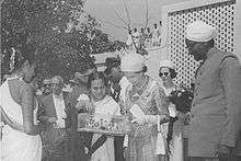
- ↑ British Pathé. "The Royal Tour Of India - Reel 3". britishpathe.com.
- ↑ "NIT DURGAPUR". nitdgp.ac.in.
- ↑ http://www.csir.res.in
- ↑ "Welcome to CMERI". cmeri.res.in. Retrieved 2013-08-25.
- ↑ "Welcome To NPTI Durgapur". www.nptidurgapur.com. Retrieved 25 March 2018.
External links
| Wikimedia Commons has media related to Durgapur. |
- Bardhaman district official site

Places adjacent to Durgapur | |
|---|---|
Cities, towns and locations in Paschim Bardhaman district | |||||
|---|---|---|---|---|---|
| Cities, municipal and census towns | |||||
| Locations other than cities and towns |
| ||||
| Neighbourhoods in Asansol |
| ||||
| Related topics |
| ||||