Basai, Hooghly
| Basai | |
|---|---|
| Census Town | |
 Basai Location in West Bengal, India  Basai Basai (India) | |
| Coordinates: 22°42′13″N 88°18′40″E / 22.703482°N 88.311117°ECoordinates: 22°42′13″N 88°18′40″E / 22.703482°N 88.311117°E | |
| Country |
|
| State | West Bengal |
| District | Hooghly |
| Population (2011) | |
| • Total | 8,772 |
| Languages | |
| • Official | Bengali, English |
| Time zone | UTC+5:30 (IST) |
| Telephone code | 033 |
| Lok Sabha constituency | Srerampur |
| Vidhan Sabha constituency | Uttarpara |
| Website |
hooghly |
Basai is a census town in Sreerampur Uttarpara CD Block in Srirampore subdivision of Hooghly district in the Indian state of West Bengal.
Geography
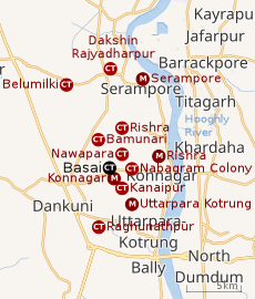 |
| Cities and towns in the Sreerampur Uttarpara CD Block in Srirampore subdivision in Hooghly district M: municipal city/ town, CT: census town, Owing to space constraints in the small map, the actual locations in a larger map may vary slightly |
Location
Basai is located at 22°42′13″N 88°18′40″E / 22.703482°N 88.311117°E[1][2]
Rishra (CT), Bamunari, Nawapara, Nabagram Colony, Kanaipur , Basai and Raghunathpur (PS-Dankuni) form a cluster of census towns on the eastern side of the series of statutory towns/ cities – Rishra, Konnagar and Uttarpara. [1]
The area consists of flat alluvial plains, that form a part of the Gangetic Delta. This belt is highly industrialised.[3]
Urbanisation
Srirampore subdivision is the most urbanized of the subdivisions in Hooghly district. 73.13% of the population in the subdivision is urban and 26.88% is rural. The subdivision has 6 municipalities and 34 census towns. The municipalities are: Uttarpara Kotrung Municipality, Konnagar Municipality, Serampore Municipality, Baidyabati Municipality, Rishra Municipality and Dankuni Municipality. Amongst the CD Blocks in the subdivision, Uttarapara Serampore (census towns shown in the map alongside) had 76% urban population, Chanditala I 42%, Chanditala II 69% and Jangipara 7% (census towns in the last 3 CD Blocks are shown in a separate map).[4][5]All places marked in the map are linked in the larger full screen map.
Demographics
As per 2011 Census of India Basai (CT) had a total population of 8,772 of which 4,511 (51%) were males and 4,261 (49%) were females. Population below 6 years was 805. The total number of literates in Basai was 7,038 (88.31% of the population over 6 years).[5]
References
- 1 2 "Census of India 2011, West Bengal: District Census Handbook, Hooghly" (PDF). Map of Serampur-Uttarpara CD Block, page 635. Directorate of Census Operations, West Bengal. Retrieved 26 September 2018.
- ↑ Note: Basai is not shown in the Google maps. Its location is based on the map published in the District Census Handbook, linked above.
- ↑ "District Census Handbook: Hugli, Series-20, Part XIIA" (PDF). Physiography, Page 17-24. Directorate of Census Operations, West Bengal, 2011. Retrieved 28 September 2018.
- ↑ "District Statistical Handbook 2014 Hooghly". Table 2.2, 2.4(a). Department of Statistics and Programme Implementation, Government of West Bengal. Retrieved 3 October 2018.
- 1 2 "C.D. Block Wise Primary Census Abstract Data(PCA)". 2011 census: West Bengal – District-wise CD Blocks. Registrar General and Census Commissioner, India. Retrieved 3 October 2018.