Durganagar
Durganagar is a neighbourhood of Kolkata in the North Dumdum and South Dum Dum municipality area, in the North 24 Parganas district in the state of West Bengal, India. It is located in North Kolkata (formerly Calcutta), beside the Netaji Subhash Chandra Bose International Airport at Dum Dum. It is a town in Kolkata, under the developmental jurisdiction of KMDA.[1]
| Durganagar | |
|---|---|
| Neighbourhood of Kolkata (Calcutta) | |
 Durganagar Location in West Bengal, India | |
| Coordinates: 22°39′10″N 88°25′11″E / 22.65266°N 88.4197°ECoordinates: 22°39′10″N 88°25′11″E / 22.65266°N 88.4197°E | |
| Country |
|
| State | West Bengal |
| City | Kolkata |
| District | North 24 Parganas |
| Languages | |
| • Official | Bengali, English |
| Time zone | UTC+5:30 (IST) |
| PIN | 700028, 700065, 700079 |
| Climate | Tropical (Köppen) |
| Website |
north24parganas |
| Town of Joy | |
Durganagar is a neighbourhood in North Dumdum municipality in Barrackpore subdivision of North 24 Parganas district in West Bengal, India.[2]In this Google map , published in the website of North Dum municipality, the outline of the limits of the municipal area is shown. On expanding the map, one can view the neighbourhoods and other locations in North Dumdum municipality.
Nimta and Dum Dum police station under Barrackpore Police Commissionerate has jurisdiction over North Dumdum municipal area.[3][4]
North Dumdum municipality is included in the Kolkata Metropolitan Area for which the KMDA is the statutory planning and development authority.[5][6]
The town is about 12 km from Sealdah station towards Bongaon and 1 km west to Netaji Subhash Chandra Bose International Airport. It was named after goddess Durga.
Kolkata Urban Agglomeration
The following Municipalities, Census Towns and other locations in Barrackpore subdivision were part of Kolkata Urban Agglomeration in the 2011 census: Kanchrapara (M), Jetia (CT), Halisahar (M), Balibhara (CT), Naihati (M), Bhatpara (M), Kaugachhi (CT), Garshyamnagar (CT), Garulia (M), Ichhapur Defence Estate (CT), North Barrackpur (M), Barrackpur Cantonment (CB), Barrackpore (M), Jafarpur (CT), Ruiya (CT), Titagarh (M), Khardaha (M), Bandipur (CT), Panihati (M), Muragachha (CT) New Barrackpore (M), Chandpur (CT), Talbandha (CT), Patulia (CT), Kamarhati (M), Baranagar (M), South Dumdum (M), North Dumdum (M), Dum Dum (M), Noapara (CT), Babanpur (CT), Teghari (CT), Nanna (OG), Chakla (OG), Srotribati (OG) and Panpur (OG).[7]
Geography
Durganagar (West) has been a part of North Dum Dum Municipality since 2000, while Durganagar (East) belongs to Dum Dum Municipality. Previously it was known as Sultanpur. Its population is about 50,000. The literacy rate is 93% in females and 94% in males, which is much higher than the national average of 59.5%; 54% of the literates are male and 46% are female. Most of the people are Hindu. Only about 200–300 Muslims are residing to its eastern side.
This place is almost pollution free with much green all around. Facilities are adequate, with almost everything nearby. But this environment was seen some 10 years ago, now many flats and buildings are constructed by destroying many playground and ponds. The number of vehicles and people have increased in a huge form. Many trees have been cut down for the Construction. But there is no bus route from Drganagar station. Very few ponds are left as well as grounds. The sudden increase in the population has taken place mainly people from outsider are settling here due to its location and low real estate prices. But after the Delhi-road (Belghoria Expressway) the price per kata has taken the acclivity. Very old residential are still belong to this place and has contributed for its development and progress. Still there is very less opportunity for the place to develop since its roads can not be widened and transportation will be only gained from its boundaries and dependent on train will be always be there. The only transport to connect Durganagar to Airport 1 No. is rickshaws and auto-rickshaws. Sometimes, less than 1 km route takes time more than an hour to reach due to unavailability of auto-vehicles.
Climate
The climate is tropical — like the rest of the Gangetic West Bengal. The hallmark is the Monsoon — from early June to mid September. The weather remains dry during the winter (mid November to mid February) and humid during summer. The temperature is always approx. -2 °C less than the standard temperature of Kolkata's reading.
Temperature: 40 °C in May (max) and 10 °C in January (min)
Relative humidity: between 55% in March & 98% in July
Rainfall: 1,579 mm (normal)[7]
Economy
Durganagar has demographics employed in different sectors like government jobs, businesses, private sectors etc.
Around a total of 32 lakh people from all around the city commute to Kolkata daily for work. In the Sealdah-Bangaon section there are 58 trains that carry commuters from 24 railway stations. In the Seadah-Hasnabad sections 32 trains carry commuters from 30 stations. [8]
It has its own post office, Allahabad Bank, AXIS Bank ATM, HDFC ATM,SBI Bank with ATM and UBI Bank with ATM a market and several playgrounds. Almost the whole population is constituted by 4-5 member small families with a single earning member. Many of them are servicemen (state/central govt. jobs), people working in IT industries and Doctors and Engineers. Residents commute daily to Kolkata through local train or by autoride to Airport which is a huge junction.
There are local markets but to avail most of the commodities like garments and jewelries people have to travel to Dum Dum Cant, the nearest place from Durganagar to have a big market.
Transport
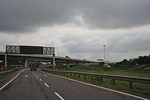
Durganagar has seen its boost up to access easier transporting communicaton by means of Belghoria Expressway which plies nearby. Now anybody from Durganagar easily go to Howrah, Bally Hault, Dankuni, Kona Expressway, Dunlop, Dakhineswar, 1no Airport Gate, Madhyamgram, Rajharhat, Saltlake (Sector-V) and different other places through bus, taxi and other vehicles ply on this road. Other area people also access this road to different places from its bus stops Sreenagar–Durganagar and Badra–Durganagar.
Durganagar has a railway station on the Sealdah-Bangaon line, which is part the Kolkata Suburban Railway railway system,[9]
Education
This place is very near to several good schools in Kolkata. Some of them are :
- Indira Gandhi Memorial High School
- Julien Day School
- St. Stephen's School
- Kishore Bharati
- Auxillium Convent
- K K Hindu Academy
- Christ Church Girls School
- Aditya Academy
- Motijheel Girls
- Baidyanath High School
The literacy rate is 93% in female and 94% in male which is very higher than the national average of 59.5%; 54% of the literates are male and 46% are female.
Culture
The place is named after the goddess Durga. Almost 3–4 Durga puja's pandels are set up during the main festive season. The 2 main ancient Pujas are at Durganagar is "Durganagar adibasi brinda", 1st which is set up at the main (Durganagar sporting club ) playground near Durganagar X Roads (Chou rasta)it is organized by Durganagar Spoting Claub and 2nd one is Uttar Durganagar Odibasi brinda set up at the (Saraj sisu Uddan) near saha katgola it is mainly Organised by the members of Bandhu Milon sangha.
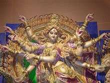
he Durga Pujas now been taken by Kali Pujas. Every year there is a big Mela happened in Sporting Club and the club also organize a big New Year brash with renowned artists and fireworks at last.
People
Well-known personalities in Durganagar include the late Dr. Nirmal Kumar Roy Chowdhury, who founded Swarnamayi Smiriti Vidyalaya, Late Radhakanta Nandi a table musician who played with Late Manna Dey. Some other renowned persons are Late Josada Lal Saha, Late Chuni Saha, Late Madhab Chandra Saha,Hore Krishna Das, Late Sudhangshu Bikash Das and ex-goalkeeper of Indian Football Team Bhaskar Ganguly is from Durganagar.
Sports

Football (soccer) is a passion of all citizens, and home of te goalkeeper Bhaskar Ganguly. Football practice and training is often happening in the ground morning and evening. Cricket is also played.
References
- ↑ "Base Map of Kolkata Metropolitan area". Kolkata Metropolitan Development Authority. Archived from the original on 2016-03-03. Retrieved 2009-01-29.
- ↑ "District Census Handbook North Twenty Four Parganas, Census of India 2011, Series 20, Part XII A" (PDF). Map of Barrackpore II CD Block on Page 379. Directorate of Census Operations, West Bengal. Retrieved 19 July 2018.
- ↑ "District Statistical Handbook". North 24 Parganas 2013, Table 2.1. Department of Statistics and Programme Implementation, Government of West Bengal. Retrieved 11 June 2018.
- ↑ "Barrackpore Police Commissionerate". List of Police Stations with telephone numbers. West Bengal Police. Retrieved 11 June 2018.
- ↑ "Kolkata Metropolitan Development Authoity, Annual Report 2010-11". 1/1 Kolkata Metropolitan Area Map. KMDA. Retrieved 7 June 2018.
- ↑ "Kolkata Metropolitan Development Authority, Annual Report 2010-11". 1 / 2 Role of KMDA. KMDA. Retrieved 7 June 2018.
- ↑ "Provisional Population Totals, Census of India 2011" (PDF). Constituents of Urban Agglomeration Having Population Above 1 Lakh. Census of India 2011. Retrieved 7 June 2018.
- ↑ Dey, Teesta. "The Suburban Railway Network of Kolkata: A Geographical Apprisal" (PDF). eTraverse, the Indian journal of spatial science, 2012. Retrieved 3 October 2018.
- ↑ "33811 Sealdah Bangaon Local". Time Table. indiarailinfo. Retrieved 4 October 2018.
External links

- Satellite view