Jaykrishnapur
| Jaykrishnapur | |
|---|---|
| Census Town | |
 Jaykrishnapur Location in West Bengal, India  Jaykrishnapur Jaykrishnapur (India) | |
| Coordinates: 22°44′38″N 88°15′45″E / 22.7440°N 88.2624°ECoordinates: 22°44′38″N 88°15′45″E / 22.7440°N 88.2624°E | |
| Country |
|
| State | West Bengal |
| District | Hooghly |
| Population (2011) | |
| • Total | 5,180 |
| Languages | |
| • Official | Bengali, English |
| Time zone | UTC+5:30 (IST) |
| Vehicle registration | WB |
| Lok Sabha constituency | Serampore |
| Vidhan Sabha constituency | Chanditala |
| Website |
wb |
Jaykrishnapur is a census town in Hooghly district in the state of West Bengal, India. It is located in Chanditala–II block in Srirampore subdivision and is served by Chanditala police station.[1]
Geography
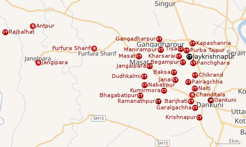 |
| Cities and towns in Chanditala I, Chanditala II and Jangipara CD Blocks in Srirampore subdivision in Hooghly district M: municipal city/ town, CT: census town, R: rural/ urban centre, Owing to space constraints in the small map, the actual locations in a larger map may vary slightly |
Location
Jaykrishnapur is located at 22°44′38″N 88°15′45″E / 22.7440°N 88.2624°E.
Kharsarai, Tisa, Kapashanria, Jaykrishnapur, Purba Tajpur, Begampur, Baksa, Panchghara, Chikrand, Janai, Pairagachha, Naiti, Barijhati, Garalgachha and Krishnapur, all the census towns form a series from the northern part of Chanditala II CD Block to its southern part. The only municipality in the area, Dankuni, located outside the CD Block, occupies the south-east corner of the entire cluster.[2]
Urbanisation
Srirampore subdivision is the most urbanized of the subdivisions in Hooghly district. 73.13% of the population in the subdivision is urban and 26.88% is rural. The subdivision has 6 municipalities and 34 census towns. The municipalities are: Uttarpara Kotrung Municipality, Konnagar Municipality, Serampore Municipality, Baidyabati Municipality, Rishra Municipality and Dankuni Municipality. Amongst the CD Blocks in the subdivision, Uttarapara Serampore (census towns shown in a separate map) had 76% urban population, Chanditala I 42%, Chanditala II 69% and Jangipara 7% (census towns shown in the map above).[3][4]All places marked in the map are linked in the larger full screen map.
Demographics
As per 2011 Census of India Jaykrishnapur had a total population of 5,180 of which 2,629 (51%) were males and 2,551 (49%) were females. Population below 6 years was 520. The total number of literates in Jaykrishnapur was 3,818 (81.93 % of the population over 6 years).[4]
Transport
The nearest railway station at Begampur is 23 kilometres (14 mi) from Howrah on the Howrah-Bardhaman chord line and is a part of the Kolkata Suburban Railway system.[5][6]
References
- ↑ "Mouza Information". Land & Land Reforms Department, Government of West Bengal.
- ↑ "Census of India 2011, West Bengal: District Census Handbook, Hooghly" (PDF). Map of Chanditala II CD Block, page 663. Directorate of Census Operations, West Bengal. Retrieved 4 October 2018.
- ↑ "District Statistical Handbook 2014 Hooghly". Table 2.2, 2.4(a). Department of Statistics and Programme Implementation, Government of West Bengal. Retrieved 3 October 2018.
- 1 2 "C.D. Block Wise Primary Census Abstract Data(PCA)". 2011 census: West Bengal – District-wise CD Blocks. Registrar General and Census Commissioner, India. Retrieved 3 October 2018.
- ↑ "36811 Howrah Bardhaman Local (via Chord)". indiarailinfo. Retrieved 6 October 2018.
- ↑ Google maps