Ichapore
| Ichapore Ishapore | |
|---|---|
| Town | |
.jpg) Ichapore Railway station | |
 Ichapore Location in West Bengal, India | |
| Coordinates: 22°49′N 88°22′E / 22.81°N 88.37°ECoordinates: 22°49′N 88°22′E / 22.81°N 88.37°E | |
| Country |
|
| State | West Bengal |
| District | North 24 Parganas |
| Government | |
| • Municipality Chairman | Moloy Kumar Ghosh |
| Elevation | 12 m (39 ft) |
| Population | |
| • Total | See North Barrackpur for population data |
| Languages | |
| • Official | Bengali, English |
| Time zone | UTC+5:30 (IST) |
| PIN | 743144 |
| Telephone code | 91 33 |
| Vehicle registration | WB 24 |
| Lok Sabha constituency | Barrackpore |
| Vidhan Sabha constituency | Noapara |
| Website |
north24parganas |
Ichapore (also written as Ichapur) is a neighbourhood in North Barrackpur municipal area in Barrackpore subdivision of North 24 Parganas district in the Indian state of West Bengal. North Barrackpur is a part of Kolkata Urban Agglomeration.
Ichhapur Defence Estate has two ordnance factories, the Rifle Factory Ishapore (RFI) and the Metal and Steel Factory (MSF) of the Ordnance Factories Board.
Overview
This town is also referred to as Ishapore with anglicized spelling. The majority of the population in Ichapore are Bengalis and they speak Bengali as their native language. A number of Biharis (settlement occurred primarily for in search of labour for the Rifle Factory) also resides in the town. The town is connected to Kolkata and nearby cities by railroad as well as paved highway. The distance between Ichapur and Sealdah Railway Stations is approximately 27 km. The various settlements and colonies in Ishapore are known as Brahminpara, Indrapuri, Sreebhumi, Maniktala, Majherpara, Chandasaheb More, Mayapally, Prantik, Debitala, Doltala, Anandamath, Mathpara, Nawabganj, Northland Estate, Eastland Estate, Goalapara, Netajipally, Kanthadhar and Badamtala, Sur Bazaar, Store Bazaar, Debikshetra, Niranjan Nagar, 10 No., Majherpara, Notun Para, Debitala. Debitala is at the west of the town just beside the River Ganges and it has a route of Autorickshaw connectivity up to Doltala at the eastern end of the town, connecting the east and west of the town keeping the Railway station of Ichapur in the middle.
Nawabganj, by the river, has numerous oldest residential buildings of the city stretching their existence far back to the early 17th Century AD. As the name implies, the Nawabs (local Kings) had their residence in this area. There are still relics from the old days in this part of the city (Famous one Pariwala bari). In the adjoining Rifle Factory Park area, Cannons from the 18th century can still be found. One of the most popular fair in this area is Jhulan Mela that takes place in Nawabganj during the month of August–September. This tradition is more than hundred years old and draws thousands of people and businesses to this fair. Rows of businesses set up their stalls along the main road of Nawabganj. The fair ends on the day of Janmashthami. Nawabganj is also the place where traditional Durga idols are immersed in the river Ganges on Dashami ending Durga Puja celebration.
Geography
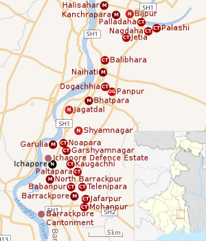 |
| Cities and towns in the northern portion of Barrackpore subdivision in North 24 Parganas district M: municipal city/ town, CT: census town, N: neighbourhood, OG: outgrowth Owing to space constraints in the small map, the actual locations in a larger map may vary slightly |
Location
Ichapore is located at 22°49′N 88°22′E / 22.81°N 88.37°E. It has an average elevation of 12 m (39 ft).[1]
96% of the population of Barrackpore subdivision (partly presented in the map alongside; all places marked on the map are linked in the full-screen map) lives in urban areas. In 2011, it had a density of population of 10,967 per km2 The subdivision has 16 municipalities and 24 census towns.[2]
For most of the cities/ towns information regarding density of population is available in the Infobox. Population data is not available for neighbourhoods. It is available for the entire municipal area and thereafter ward-wise.
Ichapore is not identified in 2011 census as a separate location and may have been included in some other location.[3]In the Map of Barrackpore I CD Block on page 365 of District Census Handbook, Ichapore railway station and the entire area around Ichhapur Defence Estate is included in North Barrackpur municipality.[4]
Post Office
Ichapur has a non-delivery sub post office, with PIN 743144 in the North Presidency Division of North 24 Parganas district in Calcutta region. Other post offices with the same PIN are the Metal and Steel Factory, Anandamath, Ichapur Nawabganj, PS Bureau, Ichapur Rifle Factory and Kantadhar.[5][6]
History
Once known by the name Bankibazar (or Banquibazar), Ichapore was a factory (trading post) of the Austrian Ostend Company during the 18th century. During the time of WWII it was a target for the invading by Japanese Imperial Air Force due to the presence of the Ordnance factories and an event of arial bombardment is also claimed to happen near the Gurudwara, which claimed many lives. The area witnessed threat from the Pakistan Air Force during the War of 1965 as East Pakistan was near to it (nearby Barrackpore witnessed a single event of aerial Bombardment).
The name Ichapore (ইছাপুর) was first mentioned in the 11th-century inscription named Manasa Vijaya Kavya (মনসা বিজয় কাব্য) written by Bipradas Pipilai (বিপ্রদাস পিপিলাই). In the medieval ages disciples of Vaishnavas resided here and was one of the remote villages of its time. Also here resided some other tribal communities like Santhals, Oraons etc.
Education
There are numerous schools which caters to the need of the residents viz.,
- Nawabgunj High School
- Rifle Factory High School
- Anandamath Vidyapith
- Northland Boys High School,
- Ichapur Girls High School,
- Ichapur Girls Primary School
- Bibhukinkar High School
- Rifle Factory Higher Secondary School
- Sridhar Banshidhar High School (The oldest school)
- Ichapore Mukhodya Girls High School
- Ichapore Morning Girls High School
All the above schools run under West Bengal Board of Secondary Education.
- Kendriya Vidyalaya, Ishapore, No.1
- Kendriya Vidyalaya, Ishapore, No.2 (under CBSE board)
There are trade schools run by the ordnance factory school. Some neighbourhoods like Anandamath and Nawabganj run their own public libraries. One of the main library in the town is Anushilani Pathagar (অনুশীলনী পাঠাগার) established far back in 1947. Other Library includes Nawabganj Sadharon Pathagar (Bengali: নবাবগঞ্জ সাধারন পাঠাগার) and Jatin Das Sadharon Granthagar (Bengali: যতীন দাস সাধারন গ্রন্থাগার)Kajol Smriti Pathagar ( কাজল স্মৃতি পাঠাগার). As for place of worships, there are many Hindu Temples, few Mosque (Muslim) and one Gurudawara (Sikhism). The nearest Christian Church is the St. Bartholomew's Church in Barrackpore. Another includes Assembly of God Church in Shyamnagar.
Economics
The two Ordnance factories, the lifeline of the city. The Metal and Steel Factory (MSF) is a unique facility that supplies metallic parts to other Ordnance factories throughout the nation. The recent model from the stable of Rifle Factory Ishapore is INSAS which is the mainstay in Indian Army as well as other security forces of India.
Banking and Financial Houses
There are few Banks and financial houses that serve the people living in Ishapore and nearby areas. State Bank of India (Near Store Bazar and at Garulia), Allahabad Bank (at Kanthadhar), Punjab National Bank, Canara Bank, Axis Bank, United Bank of India (Near Prantik) also have their presence here. Many A.T.M's have been set up all over the town.
Transport
Ichapur is connected to the nearby city Kolkata by various means of transportation. The most common transport link is through the Sealdah-Ranaghat Line of the suburban railway system.It is also well connected to other cities by roadways and frequent buses(Route no. 85 etc.) and autorickshaws are available for commuters.Cycle rickshaws are also in numbers to cover shorter distances. A newly built highway(Kalyani Expressway (Bengali: কল্যানী রোড)) has been set up on the eastern front of the town which connects the town to the airport on one end and another major town, Kalyani, on the other.
Debitala Ferry Ghat links to Gourhati Ferry Ghat across the Hooghly at Angus/ Bhadreswar.[7]
Culture and Festivals
Almost 87% of the population consists of Bengalis, most of them are 1947 & 1964 refugees of East Pakistan (now Bangladesh) who had crossed the border during partition. Local Bengalis are also found in numbers. Being a place with two huge factories, people from various parts of the country also came and got settled here. A minority of migrants are from Bihar and Uttar Pradesh, a decent number of people can be found from other parts of the country too, such as Telugu, Nepali etc. As majority of the city population belong to Hindu faith, Durga Puja is the most visible of all festivals. Other notable festivals are Diwali/Kalipuja, Jagaddhatri Puja, Saraswati Puja, Jhulon utsav, Dol jatra/Holi, Rakhi, Eid and Christmas.
Gallery
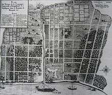 View of the Ostend Company's factory in Banquibazar, c. 1730
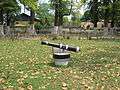 Ostend Company cannon at Ichapore
References
- ↑ "Ichapore, India Page". West Bengal. Falling Rain Genomics. Retrieved 2008-08-19.
- ↑ "District Statistical Handbook". North 24 Parganas 2013, Tables 2.1, 2.2, 2.4b. Department of Statistics and Programme Implementation, Government of West Bengal. Retrieved 2 May 2018.
- ↑ "C.D. Block Wise Primary Census Abstract Data(PCA)". 2011 census: West Bengal – District-wise CD Blocks. Registrar General and Census Commissioner, India. Retrieved 23 March 2016.
- ↑ "District Census Handbook North Twenty Four Parganas, Census of India 2011, Series 20, Part XII A" (PDF). Map of Barrackpore I CD Block on Page 365. Directorate of Census Operations, West Bengal. Retrieved 21 June 2018.
- ↑ "Locate Post Offices". West Bengal. Postal Department. Retrieved 2017-01-02.
- ↑ "Ichapur PIN Code". pincodezip.in. Retrieved 11 July 2018.
- ↑ Google maps
External links
| Wikimedia Commons has media related to Ichhapur. |
- Our Ichapur - ইছাপুর

- IIM Ichapur Chapter
- Metal & Steel factory