Masat, Hooghly
| Mosat | |
|---|---|
| Census Town | |
 Mosat Located in West Bengal, India  Mosat Mosat (India) | |
| Coordinates: 22°44′13″N 88°11′30″E / 22.736986°N 88.191802°ECoordinates: 22°44′13″N 88°11′30″E / 22.736986°N 88.191802°E | |
| District |
|
| State | West Bengal |
| District | Hooghly |
| Population (2011) | |
| • Total | 8,007 |
| Languages | |
| • Official | Bengali, English |
| Time zone | UTC+5:30 (IST) |
| PIN | 712701 |
| Lok Sabha constituency | Serampore |
| Vidhan Sabha constituency | Chanditala |
| Website | Masat |
Masat is a census town and gram panchayat in Chanditala I CD Block in the Srirampore subdivision of Hooghly district of West Bengal, India. It is under the Chanditala police station.
It is located approximately 28 km from the district headquarters of Hooghly and 33 km from the state capital, Kolkata.
Geography
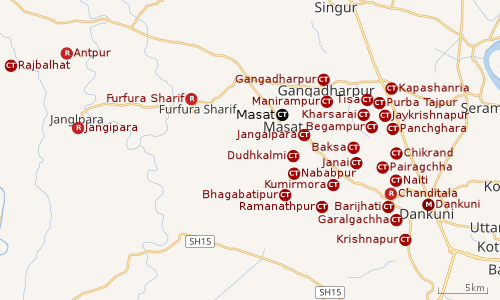 |
| Cities and towns in Chanditala I, Chanditala II and Jangipara CD Blocks in Srirampore subdivision in Hooghly district M: municipal city/ town, CT: census town, R: rural/ urban centre, Owing to space constraints in the small map, the actual locations in a larger map may vary slightly |
Location
Masat[1] is located at 22°44′13″N 88°11′30″E / 22.736986°N 88.191802°E and is a Gram panchayat.
Gangadharpur, Manirampur, Masat, Jangalpara, Dudhkalmi, Nababpur, Bhagabatipur, Kumirmora and Ramanathpur form a cluster of census towns in Chanditala I CD Block.[2]
CD Block HQ
The headquarters of Chanditala I CD Block are located at Masat.[3]
Urbanisation
Srirampore subdivision is the most urbanized of the subdivisions in Hooghly district. 73.13% of the population in the subdivision is urban and 26.88% is rural. The subdivision has 6 municipalities and 34 census towns. The municipalities are: Uttarpara Kotrung Municipality, Konnagar Municipality, Serampore Municipality, Baidyabati Municipality, Rishra Municipality and Dankuni Municipality. Amongst the CD Blocks in the subdivision, Uttarapara Serampore (census towns shown in a separate map) had 76% urban population, Chanditala I 42%, Chanditala II 69% and Jangipara 7% (census towns shown in the map above).[4][5]All places marked in the map are linked in the larger full screen map.
Gram panchayat
Villages and census towns in Masat gram panchayat are: Aushbati, Azabnagar, Banamalipur, Chhunche, Krishnanagar and Masat.[6]
Demographics
As of the 2011 Census of India, Masat has a total population of 8,007, consisting of 4,033 males and 3,974 females. The population of children under 6 years old is 752. The total number of literate people in Masat is 6,286 (86.64% of the population over 6 years of age).[5]
Transport
Railway and road
Baruipara railway station is the nearest railway station on the Howrah-Bardhaman chord of Kolkata Suburban Railway network. The main road is State Highway 15. It is the main road of the town and is connected to NH 19 (old number NH 2).
Bus Routes
Private Bus Routes
- 26 Bonhooghly – Champadanga
- 26A Sreerampore - Ausbali
- 26C Bonhooghly - Jagatballavpur
Bus Routes without Numbers
- Gajar More — Salt Lake 206 Bus Stand
- Furfura Sharif – Nabatkati
CTC Bus Routes
Education
- Colleges
Vidyasagar Mahavidyalaya, established in 1998, is a coeducational undergraduate college in Masat. It offers honours courses in Bengali, English, history, political science, education and commerce.[7][8]
- High Schools
Masat Aptap Mitra High School is a coeducational higher secondary school at Masat. It has arrangements for teaching Bengali, English, history, philosophy, political science, economics, geography, eco-geography. accountancy, business economics & mathematics, mathematics, physics, chemistry and bio-science.[9]
References
- ↑ "banglarbhumi.gov.in". WEST BENGAL ->HUGLI(হুগলী) ->CHANDITALA - I(চণ্ডীতলা-১). Archived from the original on 2016-12-22.
- ↑ "Census of India 2011, West Bengal: District Census Handbook, Hooghly" (PDF). Map of Chanditala I CD Block, page 649. Directorate of Census Operations, West Bengal. Retrieved 4 October 2018.
- ↑ "District Census Handbook: Hugli, Series-20, Part XIIA" (PDF). Map of Hooghly district with CD Block HQs and Police Stations (on the fifth page). Directorate of Census Operations, West Bengal, 2011. Retrieved 20 June 2017.
- ↑ "District Statistical Handbook 2014 Hooghly". Table 2.2, 2.4(a). Department of Statistics and Programme Implementation, Government of West Bengal. Retrieved 3 October 2018.
- 1 2 "C.D. Block Wise Primary Census Abstract Data(PCA)". 2011 census: West Bengal – District-wise CD Blocks. Registrar General and Census Commissioner, India. Retrieved 3 October 2018.
- ↑ "Banamalipur". Indian Village Directory. Retrieved 12 October 2018.
- ↑ "Vidyasagar Mahavidyalaya". VM. Retrieved 6 October 2018.
- ↑ "Vidyasaga Mahavidyalaya". College Admission. Retrieved 6 October 2018.
- ↑ "Hooghly district exam venue". West Bengal Council of Higher Secondary Education. Retrieved 11 October 2018.