Baghmundi (community development block)
| Baghmundi | |
|---|---|
| Community development block | |
 Baghmundi | |
| Coordinates: 23°12′00″N 86°03′00″E / 23.20000°N 86.05000°E | |
| Country |
|
| State | West Bengal |
| District | Purulia |
| Parliamentary constituency | Purulia |
| Assembly constituency | Baghmundi |
| Area | |
| • Total | 427.95 km2 (165.23 sq mi) |
| Elevation | 700 m (2,300 ft) |
| Population (2011) | |
| • Total | 135,579 |
| • Density | 320/km2 (820/sq mi) |
| Time zone | UTC+5.30 (IST) |
| PIN | 723152 (Baghmundi) |
| Telephone/STD code | 03254 |
| Vehicle registration | WB-55, WB-56 |
| Literacy Rate | 57.17% |
| Website | http://bdobaghmundi.in/ |
| http://purulia.gov.in/ | |
Baghmundi is a community development block that forms an administrative division in Purulia Sadar West subdivision of Purulia district in the Indian state of West Bengal.
History
Background
Jaina Bhagavati-Sutra of 5th century AD mentions that Purulia was one of the sixteen mahajanapadas and was a part of the kingdom known as Vajra-bhumi in ancient times. In 1833, Manbhum district was carved out of Jungle Mahals district, with headquarters at Manbazar. In 1838, the headquarters was transferred to Purulia. In 1956, Manbhum district was partitioned between Bihar and West Bengal under the States Reorganization Act and the Bihar and West Bengal (Transfer of Territories) Act 1956.[1]
Mythology
According to Hindu mythology, Rama and Sita had come to Ajodhya Hill, about 10 kilometres (6 mi) from Baghmundi and stayed during their exile. Sita was thirsty and Ram pierced an arrow through the Earth's soil crust and through that water gushed out. Sita quenched her thirst. The place is known as Sita-kunda. During the full moon day in Baisakh every year tribals of nearby areas come and join in the game of hunting wild animals.[2]
Red corridor
106 districts spanning 10 states across India, described as being part of the Left Wing Extremism activities, constitutes the Red corridor. In West Bengal the districts of Paschim Medinipur, Bankura, Purulia and Birbhum are part of the Red corridor. However, as of July 2016, there had been no reported incidents of Maoist related activities from these districts for the previous 4 years.[3]
The CPI (Maoist) extremism affected CD Blocks in Purulia district were: Jhalda I, Jhalda II, Arsha, Baghmundi, Balarampur, Barabazar, Manbazar II and Bandwan.[4] Certain reports also included Manbazar I and Joypur CD Blocks and some times indicted the whole of Purulia district.[5]
The Lalgarh movement, which started attracting attention after the failed assassination attempt on Buddhadeb Bhattacharjee, then chief minister of West Bengal, in the Salboni area of Paschim Medinipur district, on 2 November 2008 and the police action that followed, had also spread over to these areas.[6] The movement was not just a political struggle but an armed struggle that concurrently took the look of a social struggle. A large number of CPI (M) activists were killed. Although the epi-centre of the movement was Lalgarh, it was spread across 19 police stations in three adjoining districts – Paschim Medinipur, Bankura and Purulia, all thickly forested and near the border with Jharkhand. The deployment of CRPF and other forces started on 11 June 2009. The movement came to an end after the 2011 state assembly elections and change of government in West Bengal. The death of Kishenji, the Maoist commander, on 24 November 2011 was the last major landmark.[6][7]
Geography
Baghmundi is located at 23°12′N 86°03′E / 23.20°N 86.05°E.
Baghmundi CD Block is located in the southern part of the district. The Subarnarekha forms the interstate boundary between West Bengal and Jharkhand in Jhalda I CD Block and a small portion of Bahgmundi CD Block. The Bagmundi-Bandwan uplands is an area that has descended from the Ranchi Plateau. In the Baghmundi and Balarampur areas, the Ajodhya Hills form the main highlands, forming the drainage divide between the basins of the Subrnarekha and the Kangsabati. The elevation ranges from 475 to 700 m.[8]
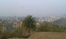
Thousands of tourists come to visit Baghmundi to witness the charm of natural beauty of Ajodhya Hills and Bagmundi dams like Murguma.
Baghmundi CD Block is bounded by Jhalda I, Jhalda II and Arsha CD Block on the north, Balarampur CD Block on the east, Kukru CD Block, in Seraikela Kharsawan district of Jharkhand, on the south, and Jhalda I CD Block on the west.
It is located 41 km from Purulia, the district headquarters.
Baghmundi CD Block has an area of 427.95 km2. It has 1 panchayat samity, 8 gram panchayats, 92 gram sansads (village councils), 142 mouzas and 138 inhabited villages. Baghmundi police station serves this block.[9] Headquarters of this CD Block is at Patardi.[10]
Gram panchayats of Baghmundi block/panchayat samiti are: Ajodhya, Baghmundi, Birgram, Burda-Kalimati, Matha, Serengdih, Sindri and Tunturi-Suisa.[11]
Demographics
Population
As per the 2011 Census of India Baghmundi CD Block had a total population of 135,579, all of which were rural. There were 69,520 (51%) males and 66,059 (49%) females. Population below 6 years was 21,992. Scheduled Castes numbered 14,042 (10.36%) and Scheduled Tribes numbered 34,038 (25.11%).[12]
As per 2001 census, Baghmundi block had a total population of 112,388, out of which 57,650 were males and 54,738 were females. Baghmundi block registered a population growth of 13.64 per cent during the 1991-2001 decade. Decadal growth for Purulia district was 13.96 per cent.[13] Decadal growth in West Bengal was 17.84 per cent.[14]
Large villages (with 4,000+ population) in Baghmundi CD Block are (2011 census figures in brackets): Baghmundi (4,039), Burda (5,159) and Sindri (4,138).[12]
Other villages in Baghmundi CD Block are (2011 census figures in brackets): Ajodhya (1,468), Patardi (1,609), Birgram (3,722), Kalimati (1,961), Serengdi (305), Tunturi (2,037), Suisa (2,649) and Matha (624).[12]
Literacy
As per the 2011 census the total number of literates in Baghmundi CD Block was 64,939 (57.17% of the population over 6 years) out of which males numbered 42,019 (72.14% of the male population over 6 years) and females numbered 22,920 (41.42%) of the female population over 6 years). The gender disparity (the difference between female and male literacy rates) was 30.72%.[12]
See also – List of West Bengal districts ranked by literacy rate
| Literacy in CD Blocks of Purulia district |
|---|
| Purulia Sadar East subdivision |
| Manbazar I – 63.78% |
| Manbazar II – 60.27% |
| Bandwan – 61.38% |
| Purulia I – 78.37% |
| Purulia II – 63.39% |
| Hura – 68.79% |
| Puncha – 68.14% |
| Purulia Sadar West subdivision |
| Jhalda I – 66.18% |
| Jhalda II – 54.76% |
| Joypur – 57.94% |
| Arsha – 57.48% |
| Baghmundi – 57.17% |
| Balarampur – 60.40% |
| Barabazar – 63.27 |
| Raghunathpur subdivision |
| Para – 65.62% |
| Raghunathpur I – 67.36% |
| Raghunathpur II – 67.29% |
| Neturia – 65.14% |
| Santuri – 64.15% |
| Kashipur – 71.06% |
| Source: 2011 Census: CD Block Wise Primary Census Abstract Data |
Languages and religions
Bengali is the local language in these areas.
There is a tribal presence in many of the CD Blocks of the district. Santali was spoken by around 14% of the population of the earlier Manbhum district. Some people also speak Mundari or Kolarian languages such as Kurmali, Mundari and the languages of the Bhumij or Mahli.[15]
In the 2011 census Hindus numbered 115,630 and formed 85.29% of the population in Baghmundi CD Block. Muslims numbered 3,882 and formed 2.86% of the population. Christians numbered 766 and formed 0.56% of the population. Others numbered 15,301 and formed 11.29% of the population.[16] Others include Addi Bassi, Marang Boro, Santal, Saranath, Sari Dharma, Sarna, Alchchi, Bidin, Sant, Saevdharm, Seran, Saran, Sarin, Kheria,[17] and other religious communities.[16]
Economy
Purulia Pumped Storage Project
Purulia Pumped Storage Project with an installed capacity of 900 MW (4 X 225 MW) is being set up in Ajodhya hills under Bagmundi police station with the loan assistance of Japan Bank for International Cooperation.[18]
Infrastructure
135 mouzas in Baghmundi CD Block were electrified by 31 March 2014.[19]
Agriculture
In 2013-14, persons engaged in agriculture in Baghmundi CD Block could be classified as follows: bargadars 0.17%, patta (document) holders 10.24%, small farmers (possessing land between 1 and 2 hectares) 3.40%, marginal farmers (possessing land up to 1 hectare) 38.42% and agricultural labourers 61.05%.[19]
In 2013-14, the total area irrigated in Baghmundi CD Block was 7,791.67 hectares, out of which 5,627.00 hectares was by canal irrigation, 1,366.75 hectares by tank water, 47.92 hectares by river lift irrigation, 103.80 hectares by open dug wells and 646.20 hectares by other means.[19]
In 2013-14, Baghmundi CD Block produced 88,370 tonnes of Aman paddy, the main winter crop, from 35,241 hectares, 170 tonnes of wheat from 72 hectares and 583 tonnes of maize from 268 hectares. It also produced maskalai, khesari and mustard.[19]
Banking
In 2013-14, Baghmundi CD Block had offices of 4 commercial banks and 1 gramin bank.[19]
Transport
In 2013-14, Baghmundi CD Block had 3 originating/ terminating bus routes. The nearest railway station Barabhum (Balarampur town) was 20 km from the CD Block headquarters.[19]
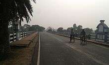
SH 4 running from Jhalda (in Purulia district) to Junput (in Purba Medinipur district) passes through this CD Block.[20]
Education
In 2013-14, Baghmundi CD Block had 139 primary schools with 12,774 students, 25 middle schools with 873 students, 1 high school with 854 students and 11 higher secondary schools with 11,273 students. Baghmundi CD Block had 1 general college with 862 students, 1 professional/ technical institution with 50 students and 193 institutions with 7,262 students for special and non-formal education.[19]
Culture
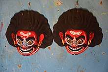
Chhau dance mask
Chhau dance is popular in the area. All the characters in the dance are required to wear masks and as such cannot express the moods with facial expressions. Such moods are expressed with body and head (with the mask) movements. While mask movements show anger, shoulder and chest movements portray joy, melancholy, courage etc. The masks used in Chhau dance are made in Charida village in the Baghmundi area by sutradharas (artisans), who have been engaged in such work for generations. The artisans, who are familiar with the details of the Indian epics, that form the base of Chhau dance themes, produce masks that bear testimony to their artistic skills.[21]
Radha Govinda temple
There is a Radha Govinda temple within Baghmundi Rajbari, dating back to 1733. It is an atchala (eight-eaves) temple with floral and geometrical terracotta designs but no figures. The rasmancha (stage) of a comparatively new temple has terracotta figures - enthroned Rama and Sita with entourage, Krishna in rasmandala with the gopis, episodes like the holding up of Giri Gobardhan, or the killing of Bakasur, and many secular figures and animals-all crudely modelled.
Healthcare
In 2014, Baghmundi CD Block had 1 block primary health centre and 3 primary health centres, with total 62 beds and 7 doctors. 7,756 patients were treated indoor and 161,919 patients were treated outdoor in the health centres and subcentres of the CD Block.[19]
Sports
Pinki Pramanik, an athlete from the remote village of Tilakdih in Bagmundi block, won a gold medal at the 15th Asian Games women's relay in Doha in 2006. She brought her first international medal at the 18th Commonwealth Games women's relay race, by winning silver in Melbourne. She made a golden hat trick at the 10th SAF Games, securing gold in 400, 800 and women's relay.[22]
References
- ↑ "Historical background". Purulia District. Archived from the original on 2008-01-03. Retrieved 19 October 2016.
- ↑ "Ajodhya Hill". SeeMyIndia. Archived from the original on 2007-10-16. Retrieved 2008-03-21.
- ↑ Singh, Vijayita. "Red Corridor to be redrawn". The Hindu, 25 July 2016. Retrieved 29 August 2016.
- ↑ "IAP improving lives in Maoist-affected areas". Ideas for India. Retrieved 26 September 2016.
- ↑ "Maoists observe 24 hr bandh in five states". UNI, One India. Retrieved 26 September 2016.
- 1 2 "Lalgarh Battle". Frontline. 17 July 2009. Retrieved 23 July 2016.
- ↑ "Kishenji's death a serious blow to Maoist movement". The Hindu. 25 November 2011. Retrieved 23 July 2016.
- ↑ "District Census Handbook Puruliya" (PDF). pages 11,12. Directorate of Census Operations West Bengal. Retrieved 6 December 2016.
- ↑ "District Statistical Handbook 2014 Purulia". Tables 2.1, 2.2,. Department of Statistics and Programme Implementation, Government of West Bengal. Archived from the original on 29 July 2017. Retrieved 12 September 2016.
- ↑ "District Census Handbook: Puruliya" (PDF). Map of District Puruliya with CD Block HQs and Police Stations (on the fifth page). Directorate of Census Operations, West Bengal, 2011. Retrieved 2 December 2016.
- ↑ "Directory of District, Subdivision, Panchayat Samiti/ Block and Gram Panchayats in West Bengal". Paschim Medinipur - Revised in March 2008. Panchayats and Rural Development Department, Government of West Bengal. Retrieved 28 September 2016.
- 1 2 3 4 "C.D. Block Wise Primary Census Abstract Data(PCA)". 2011 census: West Bengal – District-wise CD Blocks. Registrar General and Census Commissioner, India. Retrieved 12 September 2016.
- ↑ "Provisional population totals, West Bengal, Table 4, Puruliya District". Census of India 2001. Census Commission of India. Archived from the original on 28 September 2011. Retrieved 12 September 2016.
- ↑ "Provisional Population Totals, West Bengal. Table 4". Census of India 2001. Census Commission of India. Archived from the original on 27 September 2007. Retrieved 17 July 2016.
- ↑ "Bengal District Gazetteers - Manbhum by H. Coupland, ICS". Section 72, First Published 1911. University of California, San Diego. Retrieved 27 September 2016.
- 1 2 "C1 Population by Religious Community". West Bengal. Registrar General and Census Commissioner, India. Retrieved 28 September 2016.
- ↑ "ST-14 A Details Of Religions Shown Under 'Other Religions And Persuasions' In Main Table". West Bengal. Registrar General and Census Commissioner, India. Retrieved 28 September 2016.
- ↑ "Purulia Pumped Storage Project". West Bengal State Electricity Board. Retrieved 2008-03-02.
- 1 2 3 4 5 6 7 8 "District Statistical Handbook 2014 Purulia". Tables 8.2, 17.2, 18.2, 18.1, 20.1, 21.2, 4.4, 3.1, 3.3 – arranged as per use. Department of Statistics and Programme Implementation, Government of West Bengal. Archived from the original on 29 July 2017. Retrieved 6 December 2016.
- ↑ "List of State Highways in West Bengal". West Bengal Traffic Police. Retrieved 3 October 2016.
- ↑ "West Bengal Chhau". India Line Expeditions. Archived from the original on 28 February 2008. Retrieved 2008-03-02.
- ↑ Pal, Nani Gopal. "Pinki braces for Beijing Olympics". The Statesman, 21 March 2008. Archived from the original on 14 June 2012. Retrieved 24 March 2008.