Jorabagan
| Jorabagan | |
|---|---|
| Neighbourhood in Kolkata (Calcutta) | |
 | |
| Country |
|
| State | West Bengal |
| City | Kolkata |
| District | Kolkata |
| Metro Station | Girish Park |
| Municipal Corporation | Kolkata Municipal Corporation |
| KMC ward | 21 |
| Elevation | 36 ft (11 m) |
| Population | |
| • Total | For population see linked KMC ward page |
| Time zone | UTC+5:30 (IST) |
| PIN | 700 006 |
| Area code(s) | +91 33 |
| Lok Sabha constituency | Kolkata Uttar |
| Vidhan Sabha constituency | Jorasanko, Shyampukur |
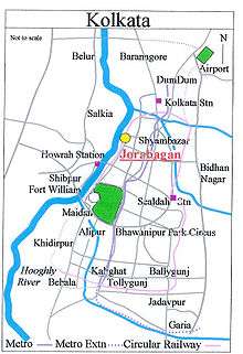
Jorabagan is a neighbourhood of north Kolkata, earlier known as Calcutta, in Kolkata district, in the Indian state of West Bengal. As a neighbourhood, it covers a small area but its importance is primarily because of the police station.[1]
Etymology
Jorabagan, meaning ‘a pair of gardens’ in Bengali, was so named because the road through it led to the garden houses of Gobindram Mitter and Umichand.[2]
History
Jorabagan is part of old Sutanuti. It is in this neighbourhood that Job Charnock made his famous landing at Sutanuti ghat in 1690. Mohunton’s ghat between Beniatola and Sobhabazar ghats lurks the forgotten traditional landing place. There was a large tree under which Job Charnock is believed to have rested.[3]
The Sabarna Roy Choudhury Paribar Parishad, and nine other intellectuals of the city filed a public interest litigation before the Kolkata High Court in 2001 demanding a probe into the matter whether Job Charnock can be regarded as the founder of Kolkata. The Court, upon an Expert Committee finding, declared that Job Charnock cannot be regarded as the founder of the city.[4][5]
In 1888, one of the 25 newly organized police section houses was located in Jorabagan.[6]
Geography
Nimtala ghat in the neighbourhood is the burning ghat where Hindus cremate their dead.[3] Amongst the more renowned people cremated there was Rabindranath Tagore and the place is marked with a memorial structure. Nimtala ghat now has an electric crematorium.
Police district
Jorabagan police station is part of the North and North Suburban division of Kolkata Police. Located at 78, Nimtala Ghat Street, Kolkata-700006, it has jurisdiction over the police district which is bordered in the north by Sova Bazar Street, in the east by Rabindra Sarani (old Upper Chitpore Road) from its junction with Grey Street to its junction with Kali Krishna Tagore Street, in the south by Jagganath Ghat Road, Strand Road, up to its junction with Kali Krishna Tagore Street, thence along Kali Krishna Tagore Street to its junction with Rabindra Sarani (old Upper Chitpore Road), and in the west by the Port Trust railway fencing from Sova Bazar Street to Jaggarnath Ghat Road.[7]
Amherst Street Women police station covers all police districts under the jurisdiction of the North and the North Suburban division i.e. Amherst Street, Jorabagan, Shyampukur, Cossipore, Chitpur, Sinthi, Burtolla and Tala.[7]
External links
![]()
References
- ↑ "Jorabagan Police Station". Kolkata Police. Archived from the original on June 8, 2007. Retrieved 2008-01-10.
- ↑ Cotton, H.E.A., Calcutta Old and New, 1909/1980, p 104, General Printers and Publishers Pvt. Ltd.
- 1 2 Cotton, H.E.A., p. 282
- ↑ Bangiya Sabarna Katha Kalishetra Kalikatah by Bhabani Roy Choudhury, (in Bengali), Manna Publication. ISBN 81-87648-36-8
- ↑ Sabarna Prithivi - website of the Sabarna Roy Choudhury family
- ↑ Nair, P.Thankappan, The Growth and Development of Old Calcutta, in Calcutta, the Living City, Vol. I, pp. 18-19, Edited by Sukanta Chaudhuri, Oxford University Press, 1995 edition.
- 1 2 "Kolkata Police". North and North Suburban Division. KP. Retrieved 5 March 2018.