Agarpara
| Agarpara | |
|---|---|
| Neighbourhood | |
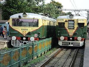 Local trains at Agarpara station | |
 Agarpara Location in Kolkata  Agarpara Agarpara (India) | |
| Coordinates: 22°41′01″N 88°23′05″E / 22.6837°N 88.3846°ECoordinates: 22°41′01″N 88°23′05″E / 22.6837°N 88.3846°E | |
| Country |
|
| State | West Bengal |
| City | Kolkata |
| Government | |
| • Municipality Chairman | Swapan Ghosh |
| Area | |
| • Total | 19.38 km2 (7.48 sq mi) |
| Elevation | 13 m (43 ft) |
| Languages | |
| • Official | Bengali, English |
| Time zone | UTC+5:30 (IST) |
| PIN | 700109, 700058 |
| Lok Sabha constituency | Dum Dum |
| Vidhan Sabha constituency | Panihati, |
Agarpara is a neighbourhood in Panihati municipality in Barrackpore subdivision of North 24 Parganas district in the state of West Bengal in India. Panihati is part of Kolkata Urban Agglomeration.
History
In the past, a community named Aghore, who were specialized in boat making, used to live here. Earlier this place was known as Agrapalli, from where the name has been changed into Aagarpara.[1]Agarpara Union was officially established on 23 July 1867. Sen estate and Sen family had been the recorded oldest inhabitant of Agarpara. Also, Ghosh family of Tarapukur, Parbat family of East Station Road and Majumder family of North Station Road are the three oldest living families in this town. Also located here in Elias Road is Banerjee Bari Which is more than 300 years old and considered the oldest house standing in this region.
Geography
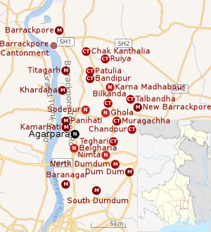 |
| Cities and towns in the southern portion of Barrackpore subdivision in North 24 Parganas district M: municipal city/ town, CT: census town, N: neighbourhood/ administrative location Owing to space constraints in the small map, the actual locations in a larger map may vary slightly |
Location
96% of the population of Barrackpore subdivision (partly presented in the map alongside, all places marked in the map are linked in the full screen map) lives in urban areas. In 2011, it had a density of population of 10,967 per km2 The subdivision has 16 municipalities and 24 census towns.[2]
For most of the cities/ towns information regarding density of population is available in the Infobox. Population data is not available for neighbourhoods. It is available for the entire municipal area and thereafter ward-wise.
Kolkata Urban Agglomeration
The following Municipalities, Census Towns and other locations in Barrackpore subdivision were part of Kolkata Urban Agglomeration in the 2011 census: Kanchrapara (M), Jetia (CT), Halisahar (M), Balibhara (CT), Naihati (M), Bhatpara (M), Kaugachhi (CT), Garshyamnagar (CT), Garulia (M), Ichhapur Defence Estate (CT), North Barrackpur (M), Barrackpur Cantonment (CB), Barrackpore (M), Jafarpur (CT), Ruiya (CT), Titagarh (M), Khardaha (M), Bandipur (CT), Panihati (M), Muragachha (CT) New Barrackpore (M), Chandpur (CT), Talbandha (CT), Patulia (CT), Kamarhati (M), Baranagar (M), South Dumdum (M), North Dumdum (M), Dum Dum (M), Noapara (CT), Babanpur (CT), Teghari (CT), Nanna (OG), Chakla (OG), Srotribati (OG) and Panpur (OG).[3]
Agarpara is a part of Panihati municipality.[4]
Economy
Industry
Agarpara is the part of the highly enriched Barrackpore Industrial Region. Famous factories like Texmaco, Duckback, Priya Biscuits operate their factories in the town. Also, the Tractor India Ltd., Himani, Aditya Shukla movie Production, National Tobacco Company and numerous jute and cotton mills establish Agarpara as an enriched industrial town,
See also - Panihati
Transport
Rail
Agarpara is one of the busiest Railway stations on the Sealdah division main section.One can reach Agarpara by Local Train within 20 to 25 minutes from Sealdeah Railway Station.
Commuters
Around a total of 32 lakh people from all around the city commute to Kolkata daily for work. In the Sealdah-Krishnanagar section there are 34 trains that carry commuters from 30 railway stations. In the Sealdah-Shantipur section 32 trains carry commuters from 29 stations.[5]
Road
There are frequent bus services which connect Agarpara to the heart of the city of Kolkata, also Howrah, Barrackpore, etc. through Barrackpore Trunk Road (BT Road) which was built during World War II as a connecting road between the army Barrack (Barrackpore) and the Army headquarters Fort William. Bus no. 230 use to run from Agarpara Railway station to Alipore Zoo regularly.Tentultala bus stop is on the cross of Elias road, north station road and B.T.road. Also, Agarpara is connected to the other side of the river Hoogly by regular ferry service. Also the famous Nilgunj Road goes through this town, Nilgunj Road is the road that connects Kolkata with Murshidabad. This is a historic one since through this road, Nawab Siraj ud-Daulah attacked the British forces at Kolkata to stop building of Fort William.
Education
Its educational facilities are good. Primary schools like Vivekananda Vidyamandir, BG Memorial & Path Bhaban Shishu Shiksha Niketan are doing really well from the last few years.Shri Saraswati Vidyalaya High School , Texmaco High School, Ushumpur Adarsha Uchha Vidalaya, Agarpara Mahajati Vidyapith, Savitri Mahajati Balika Vidyapith, Netaji Sikhshayatan are some renowned high schools here. The Narula Institute of Technology (NIT),a Sikh minority trusty organized engineering college, is situated in Agarpara. The college is affiliated to the West Bengal University of Technology (WBUT) and approved by AICTE.
Culture
The Bollywood movie Raavan, directed by Maniratnam and Tollywood films like Teen Yaari Katha, Goray Gondogol were shot here. Singers Ruprekha Banerjee and Suvankar Bhaskar come from Agarpara. The famous Bengali actress Satabdi Roy was also born here. Agarpara has some heritage site also. Giribala thakurbari is one of that which is built by GlribalaDasi, granddaughter of Rani Rasmoni who built Dwakshneswar temple.
References
- ↑ "Panihati Municipality". Historical background. PM. Retrieved 25 June 2018.
- ↑ "District Statistical Handbook". North 24 Parganas 2013, Tables 2.1, 2.2, 2.4b. Department of Statistics and Programme Implementation, Government of West Bengal. Retrieved 2 May 2018.
- ↑ "Provisional Population Totals, Census of India 2011" (PDF). Constituents of Urban Agglomeration Having Population Above 1 Lakh. Census of India 2011. Retrieved 7 June 2018.
- ↑ ":: Welcome to Panihati Municipality ::". Panihatimunicipality.in. Retrieved 2014-02-27.
- ↑ Dey, Teesta. "The Suburban Railway Network of Kolkata: A Geographical Apprisal" (PDF). eTraverse, the Indian journal of spatial science, 2012. Retrieved 12 June 2018.