Tarakeswar
| Tarakeswar | |
|---|---|
| Town | |
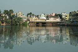 Baba Taraknath Temple of Tarakeshwar | |
 Tarakeswar Location in West Bengal, India  Tarakeswar Tarakeswar (India) | |
| Coordinates: 22°53′N 88°01′E / 22.89°N 88.02°ECoordinates: 22°53′N 88°01′E / 22.89°N 88.02°E | |
| Country |
|
| State | West Bengal |
| District | Hooghly |
| Government | |
| • Type | Representative Democracy |
| • Body | Tarakeswar Municipality |
| Elevation | 18 m (59 ft) |
| Population (2011)[1] | |
| • Total | 30,947 |
| Languages | |
| • Official | Bengali, English |
| Time zone | UTC+5:30 (IST) |
| Telephone code | 91 3212 |
| ISO 3166 code | IN-WB |
| Lok Sabha constituency | Arambag |
| Vidhan Sabha constituency | Tarakeswar |
| Website |
wb |
Tarakeswar (pronounced Tarokeshshor) is a town and a municipality in Hooghly district in the Indian state of West Bengal. It is also one of the police stations under Chandannagore subdivision.[2] Tarakeswar is a place of pilgrimage and a centre of the Shaiva sect in West Bengal 58 kilometres (36 mi) away from Kolkata, Tarakeswar can be reached conveniently by train.
Geography
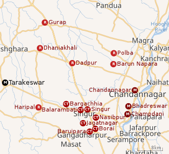 |
| Cities and towns in the Chandannagore subdivision and Polba Dadpur and Dhaniakhali CD Blocks of Chinsurah subdivision in Hooghly district M: municipal corporation/ municipal city/ town, CT: census town, R: rural/ urban centre, Owing to space constraints in the small map, the actual locations in a larger map may vary slightly |
Location
Tarakeswar is located at 22°53′N 88°01′E / 22.89°N 88.02°E. It has an average elevation of 18 metres (59 feet). It is in the Chandannagore sub-division in Hooghly District of Burdwan Division in the state of West Bengal. It is situated in the middle part of the Hooghly District. The town is connected both by railway and State Highway. The town is 48 kilometer from Chinsurah, the district headquarter and 45 kilometer from Chandannagore [3], the Sub-Divisional Headquarter and 58 km from Kolkata, the state capital by railway (BG). It is also connected with other urban centers of district with motorable roads.
Climate
Tarakeswar has a tropical wet and dry climate under Köppen climate classification.
Area and Administrative boundary
At present the area of the town is 3.88 square kilometres (1.50 sq mi). The Tarakeswar Municipality area is divided into 15 wards for administrative purpose. Tarakeswar town is situated in the center of Tarakeswar Block. Four Gram Panchayets surround this Municipality. North portion of this town is Bhanjipur Gram Panchayat, south portion is Ramnagar Gram Panchayet, east portion is Baligori (1) Gram Panchayet and west portion is Santoshpur Gram Panchayat.[4]
Administrative set up
Tarakeswar is in the Chandannagore Sub-Division under the Burdwan Division in the District of Hooghly. It is also under the Tarakeswar Police Station. It received the status of Municipality on 6 August 1975 .
Police station
Tarakeswar police station has jurisdiction over Tarakeswar municipal areas and Tarakeswar CD Block.[5][6]
CD Block HQ
The headquarters of Tarakeswar CD Block are located at Tarakeswar.[7]
Demographics
As per 2011 Census of India, Tarakeswar had a total population of 30,947 of which 16,049 (52%) were males and 14,898 (48%) were females. Population below 6 years was 2,685. The total number of literates in Tarakeswar was 23,711 (83.90% of the population over 6 years).[8]
As of 2001 India census,[9] Tarakeswar had a population of 28,178. Males constitute 53% of the population (i.e., 14,986) and females 47% (i.e., 13,192). The Sex ratio (i.e. number of female per 1000 males) of population is 880. In Tarakeswar, 10% of the population is under 6 years of age. The gross density of population is 7262 person per Sq.km. Tarakeswar has an average literacy rate of 72%, higher than the national average of 59.5%: male literacy is 78%, and female literacy is 66%.
Out of a total population of 30,947, 93.22% were Hindu, 4.97% were Muslim while other religions and atheism comprised the rest.[10]
Economy
The main occupation of the town is Agriculture. Trade and commerce also play an important role.
Around a total of 32 lakh people from all around the city commute to Kolkata daily for work. In the Howrah-Tarakeswar section there are 48 trains that carry commuters from 21 railway stations.[11]
Taraknath Temple
Pilgrims visit the Taraknath Temple throughout the year, especially on Mondays. Thousands of pilgrims visit Tarakeswar on the occasions of Shravani Mela, on the month of July–August (Srabon in Bengali calendar) and Gajan.
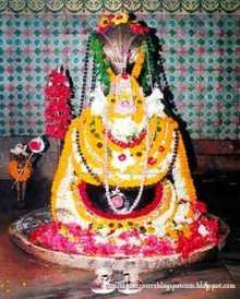
Taraknath Temple is a famous Hindu shrine located in the town of Tarakeswar in Hooghly district of West Bengal, India. The temple enshrines a Shayambhu linga of Lord Shiva. The temple is believed to be constructed in 1729 AD by Raja Bharamalla.
Taraknath Mandir was built in an ‘Atchala’ structure of Bengal temple architecture with a ‘natmandir’ in front. The temple features four roofs above the sanctum and extended galleries for the congregation of the devotees. Dudhpukur pond, located north of the temple, is believed to fulfill the prayers of those taking a dip in it. The temple is also claimed to be one of the Jyothirlinga shrines of Mahadev.
Education
The town has 3 higher secondary schools, 1 secondary school, 14 primary schools out of which six are Govt. sanctioned and 8 private school. There are also one college, 3 Shishu Shikha Centre, 2 Branch centers of Open University and Open School and, one Vocational Education & Training Centre. Primary schools in the town are Vidyamandir, Girindra Prathamik Vidyalaya, Hindi School, Anandamarg Primary School, Ramkrishna Vidyamandir, Sishu Niketan, Ankur, Bhanjipur SSK, Children's Aim, Scarlet Academy, Sahapur Primary School. The high schools are Tarakeswar High School (Boys), Tarkeswar Girls' School, Bikash Bharati Blooms Day School, Kendriya Vidyalaya, and Tarakeswar Mahavidyalaya ( H.S. unit ).
Tarakeswar Degree College was established at Tarakeswar in 1986. It is affiliated with the University of Burdwan and offers honours courses in Bengali, English, Sanskrit, sociology, history, philosophy, geography, music, accountancy, chemistry and computer science. It has an undergraduate course in business administration.[12][13]
Transport
Road Transport:
The town has got about 45.493 km road out of which 13.436 km is Bituminous Road, 10.483 km is a concrete road, 11.801 km is brick pavement, 1.857 km is Bats-Moorum roads and 7.914 km Kancha Road.
Rail Transport:
The town has got a status of Model Station of Eastern Railway. The distance between Howrah and Tarakeswar is 58 km. It has already situated as a transportation center for potato and other green vegetables in the southern Bengal.
The Howrah-Tarakeswar line was opened in 1885.[14] Tarakeswar railway station was also a terminal for the Bengal Provincial Railway. It is part of the Kolkata Suburban Railway system.[15] Tarakeswar Railway Station is declared as a Multifunctional Station. The present Railway Line between Sheoraphuli railway station and Tarakeswar has been extended to Bishnupur in Bankura via Arambagh. Tarakeswar Railway station Enquiry number is: 03212276190.
Communication
Champadanga area Telephone Exchange with Dialling code 03212 serves: Begampur, Bhagabatipur, Champadanga, Chanditala, Dihi-batpur, Dwarhatta, Piyasara, Gopinagar, Haripal, Harinkhola, Jangipara, Jinpur, Dulalbati, Mashat, Nalikul, Rajbalahat, Shaympur, Pratiharpur, Loknath, Tarakeswar, Talpur, Taukipur and Mayapur. WCDMA and LTE network are also available here.[16]
See also
References
- ↑ http://www.censusindia.gov.in/pca/SearchDetails.aspx?Id=343377
- ↑ District-wise list of statutory towns Archived 2007-09-30 at the Wayback Machine.
- ↑ "Chandannagar". Wikipedia. 2017-03-22.
- ↑ "Tarakeswar Municipality". TM. Retrieved 14 July 2017.
- ↑ "District Statistical Handbook 2014 Hooghly". Tables 2.1, 2.2,. Department of Statistics and Programme Implementation, Government of West Bengal. Retrieved 3 October 2018.
- ↑ "Hooghly District Police". West Bengal Police. Retrieved 20 June 2017.
- ↑ "District Census Handbook: Hugli, Series-20, Part XIIA" (PDF). Map of Hooghly district with CD Block HQs and Police Stations (on the fifth page). Directorate of Census Operations, West Bengal, 2011. Retrieved 20 June 2017.
- ↑ "2011 Census – Primary Census Abstract Data Tables". West Bengal – District-wise. Registrar General and Census Commissioner, India. Retrieved 15 June 2016.
- ↑ "Census of India 2001: Data from the 2001 Census, including cities, villages and towns (Provisional)". Census Commission of India. Archived from the original on 2004-06-16. Retrieved 2008-11-01.
- ↑ "Tarakeswar City Population Census 2011 - West Bengal". www.census2011.co.in. Retrieved 2016-11-21.
- ↑ Dey, Teesta. "The Suburban Railway Network of Kolkata: A Geographical Apprisal" (PDF). eTraverse, the Indian journal of spatial science, 2012. Retrieved 8 October 2018.
- ↑ "Tarakeswar Degree College". TDC. Retrieved 30 June 2017.
- ↑ "Tarakeswar Degree College". College Admission. Retrieved 30 June 2017.
- ↑ Chaudhuri, Sukanta, The Railway Comes to Calcutta, in Calcutta, the Living City, Vol. I, edited by Sukanta Chaudhuri, p. 239, Oxford University Press, ISBN 978-0-19-563696-3.
- ↑ http://erail.in?T=TAK::HWH:
- ↑ "Adjacent Area Dialling Schemes". BSNL. Archived from the original on 2011-07-21. Retrieved 2009-01-29.
| Bankura |  | |
|---|---|---|
| Bardhaman |
| |
| Birbhum |
| |
| Hooghly | ||
| Howrah | ||
| Jalpaiguri | ||
| Kolkata | ||
| Nadia |
| |
| North 24 Parganas |
| |
| Medinipur | ||
| Centres | ||