Jirat
| Jirat | |
|---|---|
| Census town | |
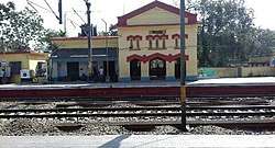 Jirat Railway Station | |
 Jirat Location in West Bengal, India  Jirat Jirat (India) | |
| Coordinates: 23°5′54″N 88°27′42″E / 23.09833°N 88.46167°ECoordinates: 23°5′54″N 88°27′42″E / 23.09833°N 88.46167°E | |
| Country |
|
| State | West Bengal |
| District | Hooghly |
| Founded by | British |
| Government | |
| • Type | Panchayet |
| • Body | Jirat Panchayet |
| Population (2011) | |
| • Total | 7,430 |
| Languages | |
| • Official | • Bengali, English |
| Time zone | UTC+5:30 (IST) |
| PIN | 712 501 |
| Telephone code | +91 3213 |
| Vehicle registration | • WB 16, WB 18 and WB 15 (only for commercial use) |
| Sex ratio | 3,606 (49%) ♀/3,824 (51%) ♂ |
| Literacy | 79.01% |
| Lok Sabha constituency | Hooghly |
| Vidhan Sabha constituency | Balagarh |
Jirat is a census town of the Hooghly district in the Indian state of West Bengal. It is situated on the western bank of the Hooghly River and is about 71 km (44 mi) away from Kolkata.
Geography
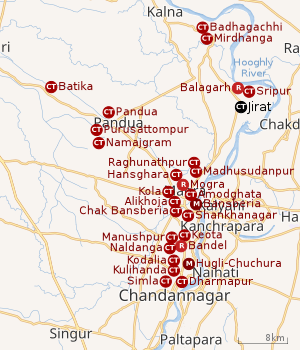 |
| Cities and towns in the Chinsurah subdivision (except Polba Dadpur and Dhaniakhali CD Blocks) in Hooghly district M: municipal city/ town, CT: census town, R: rural/ urban centre, Owing to space constraints in the small map, the actual locations in a larger map may vary slightly |
Location
Jirat is the Main Administrative Center (Sadar) of Balagarh Block. Balagarh Bijoy Krishna Mahavidyalaya, Balagarh BDO Office, and Jirat Hospital are located in Jirat.
The Balagarh CD Block is mosty part of the Hooghly Flats, one of the three natural regions in the district composed of the flat alluvial plains that form a part of the Gangetic Delta. The region is a narrow strip of land along the 80 km long stretch of the Hooghly River, that forms the eastern boundary of the district.[1]
Urbanisation
There are 13 statutory towns and 64 census towns in Hooghly district. The right bank of the Hooghly River has been industrialised over a long period. With foreigners dominating the area’s industry, trade and commerce for over two centuries, it is amongst the leading industrialised districts in the state. At the same time the land is fertile and agricultural production is significant.[2]
In Chinsurah subdivision 68.63% of the population is rural and the urban population is 31.37%. It has 2 statutory and 23 census towns.[3] In Chinsurah Mogra CD Block 64.87% of the population is urban and 35.13% is rural. Amongst the four remaining CD Blocks in the subdivision two were overwhelmingly rural and two were wholly rural.[4]
The map above shows a portion of Chinsurah subdivision. All places marked in the map are linked in the larger full screen map.
Demographics
As per the 2011 Census of India, Jirat had a total population of 7,430, of which 3,824 (51%) were males and 3,606 (49%) were females. The total number of literates in Jirat was 5,308 (79.01% of the population over 6 years).[4]
Transport
Jirat Railway Station is an important railway station in the Bandel-Katwa Branch Line. The State Highway 6 (West Bengal) passes through Jirat.[5] The nearest airport from Jirat is Netaji Subhas Chandra Bose International Airport which is 58 km away. Approximate driving distance between Kolkata and Jirat is 71 km (44 mi). Jirat is also connected with Chuchura to Kalna by Bus (Bus Route 8).
Temples
The oldest temples in Jirat are:
- Sri Sri Gapinath Jeu (Smritrimandir)
- Sideswari Kali
- Mahakal Bairav (Kaliagarh)
- Sri Sarvamangala Kali Mata Temple (Asanpur)
- Darmaraj Temple (Mundukhola)
- Bura Siva Temple(Panchpara)
Healthcare
A variety of hospitals, nursing homes, and sub-health centers have branches in Jirat, with notable examples being Ahammedpur Block Health Care Center, Envision Eye Foundation and a private Eye Hospital.
Education
The following educational institutions are located in Jirat.
- Balagarh Bijoy Krishna Mahavidyalaya (College)
- Jirat Colony High School (Government Higher Secondary School for Boys)
- Holy Child Academy, Jirat (Private English Medium School)
- Sishu Siskha Niketan (Private School)
- Kabura Panchpara High School (Government Higher Secondary School)
- Little Angeles Academy (Private English Medium Nursery School)
- Ashutosh Smritimandir Girls High School (Government High School for Girls)
- Balagarh High School (Government Higher Secondary School)
Notable persons
- Sir Ashutosh Mukherjee (Educator and the second indian Vice-Chancellor of the University of Calcutta).
- Panchanan Karmakar (Inventor of wooden Bengali alphabet).
- Charuchandra Banerjee (Poet)
- Anil Chaterjee (Artist)
- Shyama Prasad Mukherjee (Indian Politician)
References
- ↑ "District Census Handbook: Hugli, Series-20, Part XIIA" (PDF). Physiography, Page 17. Directorate of Census Operations, West Bengal, 2011. Retrieved 27 September 2018.
- ↑ "District Census Handbook: Hugli, Series-20, Part XIIA" (PDF). Physical features: pages 20, 24. Directorate of Census Operations, West Bengal, 2011. Retrieved 27 September 2018.
- ↑ "District Statistical Handbook 2014 Hooghly". Table 2.1, 2.2, 2.4(a). Department of Statistics and Programme Implementation, Government of West Bengal. Retrieved 27 September 2018.
- 1 2 "C.D. Block Wise Primary Census Abstract Data(PCA)". 2011 census: West Bengal – District-wise CD Blocks. Registrar General and Census Commissioner, India. Retrieved 27 September 2018.
- ↑ "List of State Highways in West Bengal". West Bengal Traffic Police. Retrieved 15 October 2016.