Harmasra
| Harmasra Harmara | |
|---|---|
| Village | |
 Harmasra Location in West Bengal, India  Harmasra Harmasra (India) | |
| Coordinates: 23°01′28″N 87°00′00″E / 23.024423°N 87.000117°ECoordinates: 23°01′28″N 87°00′00″E / 23.024423°N 87.000117°E | |
| Country |
|
| State | West Bengal |
| District | Bankura |
| Population (2011) | |
| • Total | 3,131 |
| Languages | |
| • Official | Bengali, English |
| Time zone | UTC+5:30 (IST) |
| ISO 3166 code | IN-WB |
| Vehicle registration | WB |
| Lok Sabha constituency | Bankura |
| Vidhan Sabha constituency | Taldangra |
| Website |
wb |
Harmasra is a gram panchayat under Taldangra intermediate panchayat, in Khatra subdivision of Bankura district in the Indian state of West Bengal.[1]
Geography
Harmasra is located at 23°01′28″N 87°00′00″E / 23.024423°N 87.000117°E
Census villages under Harmasra village panchayat are: Kadamara, Sulgi, Kiasol, Marasol, Harmasra, Keshetara, Bhimara, Chunalu, Dolbagicha, Jarkapaksara, Karanjabedia, Baghdoba, Ghagar, Patharkura, Tilabani, Kuldiha, Chakkuldiha, Sushunia, Mahishakanali, Bali Bandh, Nabagram, Maibandhi, Khichka,Rampur Kolsuli, Jamua.[1]
There are some small but picturesque water falls along the course of the Shilabati near Harmasra,[2]
Demographics
As per 2011 Census of India Harmasra had a total population of 3,131 of which
- Males= 1,581 (50%)
- Females= 1,550 (50%).
- Population below 6 years was 341.
- The total number of literates in Harmasra was 2,044 (73.26% of the population over 6 years).[3]
Transport
Railways
The nearest railway station to Harmasra is Bheduasol which is located in and around 23.4 kilometer distance. Bankura Railway Station is the most important among others. The following table shows other railway stations and its distance.
- Bheduasol railway station = 23.4 km.
- Bankura railway station = 23.5 km.
- Bishnupur railway station = 31.1 km.
- ShriRampuram railway station = 46.7 km.
- Kalipahari railway station = 47.1 km.
Airports
Harmasra‘s nearest airport is Kazi Nazrul Islam Airport (located in Panagarh) situated at 63.7 km distance. Nearest International Airport is Netaji Subhash Chandra Bose International Airport (located in Kolkata) situated at 183 km. Below list shows the nearest airport and distance.
- Kazi Nazrul Islam Airport, Andal - 63.7 km.
- Chakulia Airport - 68.7 km.
- Netaji Subhash Chandra Bose International Airport, Dum Dum, Kolkata - 183.5 km.
Culture
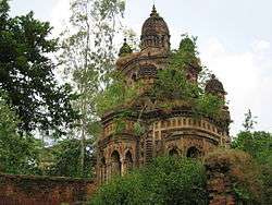
Bankura district was once under the influence of Jainism and a number of Jain relics lie scattered in the district. Jain relics at villages Sonatapal, Bahulara, Dharapat, Harmasra and Paresnath (near Ambiknagar) are now taken as Hindu relics and some of the intact images are daily worshipped as Hindu deities.[4] Harmasra has Jain temple made up of bricks with a shikhara. The temple has an image of Parshavanatha along with small images of other tirthankars.[5] Durga festival is also widely celebrated in this village and is the main festival in the village.
Education
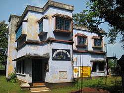
Harmasra has a Higher Secondary School that is situated just outside the main village. It was established in 1921. It has science and arts streams. The school has good laboratory facilities. Students from nearby villages come here to study. Below list shows all the schools located nearby Harmasra and its distance.
- Harmasra High School - 0.6 km.
- Harmasra Girls School - 0.2 km.
Gallery
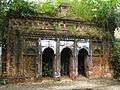 An Old Temple
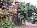 Jain Temple
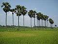 Near Harmasra School
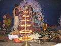 Harmasra Durga Puja
References
| Wikimedia Commons has media related to Harmasra. |
- 1 2 "Village Panchayats of Taldangra, Bankura, West Bengal". Reports of National Panchayat Directory. Ministry of Panchayati Raj, Government of India. Retrieved 2009-09-15.
- ↑ O’Malley, L.S.S., ICS, Bankura, Bengal District Gazetteers, pp.1-20,1995 reprint, Government of West Bengal
- ↑ "2011 Census – Primary Census Abstract Data Tables". West Bengal – District-wise. Registrar General and Census Commissioner, India. Retrieved 14 October 2016.
- ↑ "Temples and Legends of Bengal". Bankura. Hindu Books. Retrieved 2009-07-12.
- ↑ Sajnani, Manohar (2001). Encyclopaedia of Tourism Resources in India. 2nd volume. Gyan Publishing House. p. 346. ISBN 9788178350141.
Cities, towns and locations in Bankura District | |||||||
|---|---|---|---|---|---|---|---|
| Cities, municipal and census towns |
| ||||||
| Locations other than cities and towns |
| ||||||
| Related topics |
| ||||||