Panihati
| Panihati | |
|---|---|
| Neighbourhood in Kolkata (Calcutta) | |
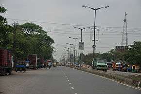 Barrackpore Trunk Road at Panihati | |
 Panihati Location in Kolkata  Panihati Panihati (India) | |
| Coordinates: 22°41′N 88°22′E / 22.69°N 88.37°ECoordinates: 22°41′N 88°22′E / 22.69°N 88.37°E | |
| Country |
|
| State | West Bengal |
| City | Kolkata |
| Government | |
| • Municipality Chairman | Swapan Ghosh |
| Area | |
| • Total | 19.38 km2 (7.48 sq mi) |
| Elevation | 13 m (43 ft) |
| Population (2011) | |
| • Total | 377,347 |
| • Density | 19,000/km2 (50,000/sq mi) |
| Languages | |
| • Official | Bengali, English |
| Time zone | UTC+5:30 (IST) |
| PIN | 700109, 700110, 700111, 700114, 700115 |
| Lok Sabha constituency | Dum Dum |
| Vidhan Sabha constituency | Panihati, |
Panihati is a city with a municipality in Barrackpore subdivision of North 24 Parganas district in the Indian state of West Bengal. It is a part of Kolkata Urban Agglomeration.
History
There is a legendary belief that Maharaja Chandraketu of Deganga established a garh (fort) at Panihati in the 13th century. There is an association of goddess Bhawani with the fort. In the early days when river transport was the primary means of communication, Panihati was a major trading and business centre, then known as Pannyahati (Emporium for the Merchandise). Scholars feel that the name has come from the word Pannyahatic. Panihati is mentioned in several Vaishnava Padavali literary texts – Chaitanya Mangal Kavya by Jayananda and Lochandas in the 16th century, Sri Chaitanya Bhagawat by Brindaban Das in 1548, Bansi Bistar by Nityannda, Vaishnava Namdeva by Debaki Nandan, Sri Chaitanya Charitamritam by Krishnadas Kabiraj in 1580-1610, Bhakti Ratnakar and Chaitanya Chandroday.[1] Panihati Municipality was established in 1900.[2]. This place is said to be visited by Sri Chaitanya Mahaprabhu on his way to Puri & later by his close associate Nityananda too, due to which Gaudiya Vaishnavas consider this place holy.
With the partition of Bengal in 1947, "millions of refugees poured in from erstwhile East Pakistan."[3] In the initial stages bulk of the refugees were non-agriculturists. A few of them made their own arrangements, but "it was squatters who made the East Bengali refugees famous or infamous." Squatting (jabardakhal in Bengali) ranged from the forcible occupation of barracks to the collective take-over of private, government and waste land. "This happened as early as 1948 with middle class refugees in the Jadavpur area: first on government land and then on private property, leading to violent clashes. Having won the battle, the elated squatters named their colony ‘Bijaygarh’, the Fort of Victory." By 1949, there were 40 such colonies in Jadavpur, Kasba, Santoshpur, Garia and Behala, in the south-eastern part of the city, and 65 in the Dum Dum and Panihati zone in the north. Subsequently squatters colonies also came up along the west bank of the Hooghly and by 1950, there were 150 such colonies. It has to be borne in mind that the squatters were in a way “self-settlers” in the absence of adequate official arrangements for rehabilitation. Within a very short time the refugees (quite often with government/ administrative support) not only found a place to stay but developed a society with markets, schools, temples and sometimes even colleges, hospitals and recreational centres.[4][5] Efforts have been made in more recent years to regularise land/property rights in the refugee colonies.[6][7][8][9]
Geography
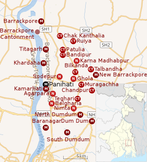 |
| Cities and towns in the southern portion of Barrackpore subdivision in North 24 Parganas district M: municipal city/ town, CT: census town, N: neighbourhood/ administrative location Owing to space constraints in the small map, the actual locations in a larger map may vary slightly |
Location
Panihati has an average elevation of 13 metres (42 feet).
96% of the population of Barrackpore subdivision (partly presented in the map alongside, all places marked in the map are linked in the full screen map) lives in urban areas. In 2011, it had a density of population of 10,967 per km2 The subdivision has 16 municipalities and 24 census towns.[10]
For most of the cities/ towns information regarding density of population is available in the Infobox. Population data is not available for neighbourhoods. It is available for the entire municipal area and thereafter ward-wise.
Panihati is bounded by Bandipur, Iswaripur and Karna Madhabpur on the north, Manish Pota, Bilkanda, Jugberia, Muragachha and Teghari on the east, North Dumdum and Kamarhati on the south, and Khardaha on the west.[11]
Panihati Municipality is located on BT Road, Kolkata - 700110 at the western side of Sodepur rail station.
Police station
Ghola police station under Barrackpore Police Commissionerate has jurisdiction over Panihati and New Barrackpore municipal areas.[12][13]
Demographics
Population
| Population of Panihati | |||
|---|---|---|---|
| Census | Pop. | %± | |
| 1901 | 11,178 | — | |
| 1911 | 11,118 | -0.5% | |
| 1921 | 10,161 | -8.6% | |
| 1931 | 11,699 | 15.1% | |
| 1941 | 27,410 | 134.3% | |
| 1951 | 49,514 | 80.6% | |
| 1961 | 93,749 | 89.3% | |
| 1971 | 148,046 | 57.9% | |
| 1981 | 205,718 | 39.0% | |
| 1991 | 275,990 | 34.2% | |
| 2001 | 348,438 | 26.3% | |
| 2011 | 377,347 | 8.3% | |
| Source:[14] | |||
As per the 2011 Census of India, Panihati had a total population of 377,347, of which 189,446 (50%) were males and 187,901 (50%) were females. Population below 6 years was 26,215. The total number of literates in Panihati was 322,770 (91.92% of the population over 6 years).[15]
As of 2001 India census,[16] Panihati had a population of 348,379. Males constitute 52% of the population and females 48%. Panihati has an average literacy rate of 82%, higher than the national average of 74.4%: male literacy is 85%, and female literacy is 79%. In Panihati, 8% of the population is under 6 years of age.
Kolkata Urban Agglomeration
The following Municipalities, Census Towns and other locations in Barrackpore subdivision were part of Kolkata Urban Agglomeration in the 2011 census: Kanchrapara (M), Jetia (CT), Halisahar (M), Balibhara (CT), Naihati (M), Bhatpara (M), Kaugachhi (CT), Garshyamnagar (CT), Garulia (M), Ichhapur Defence Estate (CT), North Barrackpur (M), Barrackpur Cantonment (CB), Barrackpore (M), Jafarpur (CT), Ruiya (CT), Titagarh (M), Khardaha (M), Bandipur (CT), Panihati (M), Muragachha (CT) New Barrackpore (M), Chandpur (CT), Talbandha (CT), Patulia (CT), Kamarhati (M), Baranagar (M), South Dumdum (M), North Dumdum (M), Dum Dum (M), Noapara (CT), Babanpur (CT), Teghari (CT), Nanna (OG), Chakla (OG), Srotribati (OG) and Panpur (OG).[17]
Infrastructure
As per the District Census Handbook 2011, Panihati municipal city covered an area of 19.38 km2. Amongst the civic amenities it had 375 km of roads and both open and covered drains. Amongst the medical facilities It had 48 medicine shops. Amongst the educational facilities It had 116 primary schools, 123 middle schools, 132 secondary schools, 162 senior secondary schools and 12 non-formal education centres. Amongst the social, recreational and cultural facilities it had 1 orphanage home, 1 stadium, 3 cinema/ thetres, 10 auditorium/ community halls, 78 public libraries and 20 reading rooms. Amongst the commodities manufactured were railway wagons, pumps and waterproofs. It had 14 bank branches.[18]
According to Barrackpore administration the educational facilities available in Panihati are: 100 primary schools, 2 English-medium schools, 12 secondary schools, 10 higher secondary schools, 2 degree colleges, 2 engineering colleges and 1 medical/dental college. Other facilities are: 153.18 km pucca roads, 197 km kutcha roads, 249 km pucca drains, 410 km kutcha drains, 5 municipal markets, 10 private markets, 9 post offices/ sub post offices, 1 ferry ghat (Mahatsabtala-Konnagar), 3 cinema halls (Padma, Rathindra, Mini Rathindra), 12 play grounds (8 big, 4 small), 1 electric crematorium, 3 burning ghats and 2 Muslim burial grounds. 33,000 houses have water connection and there are 2,842 street taps.[2]
Economy
Industry
The following industries are/ were located in Panihati:
- Bengal Chemicals and Pharmaceuticals, founded by Acharya Prafulla Chandra Ray with its main plant on Maniktala Main Road, now in Kankurgachi neighbourhood of Kolkata, established a plant at Panihati in 1920. It is presently a central-government undertaking.[19][20][21]
- Bengal Waterproof Works Private Ltd. (popular for their Duckback brand), was established in 1920 at Kolkata and shifted to Panihati in 1932 by four brothers – Surendranath, Jogendramohan, Ajitmohan, and Bishnupada Bose.[19]
- Basanti Cotton Mill was established by Subodh Chandra Mitra in 1934. Named after Basanti Devi, wife of Deshbandhu Chittaranjan Das, it was inaugurated by Rabindranath Tagore and presided over by Acharya Prafulla Chandra Ray. It is no more in operation.[19][22][23][24] Basanti Cotton Mill was closed down in 1987.[25]
- Bangasree and Sodepur Cotton Mills, founded by Rai Bahadur D.N.Chowdhury and Chandrachur Chowdhury, were subsequently taken over by National Textile Corporation.[19]
- Bangodaya Cotton Mill was locked out in 1984. The factory sheds have been cleared out and Peerless Abasan now occupies the space.[19][26]
- Texmaco Rail and Engineering Ltd., with 5 manufacturing units spread across Kamarhati and Panihati municipalities. Founded in 1939 by K.K. Birla, and now the flagship company of the Adventz Group, headed by Saroj Poddar.[27][28]
KMDA
Panihati municipality is included in the Kolkata Metropolitan Area for which the KMDA is the statutory planning and development authority.[29][30]
Transport
Panihati covers two important railway stations on the Sealdah north main section line:[31]
1) Sodepur - a densely populated urban area connected to the northern side of Kolkata by Barrackpore Trunk Road and with Barasat via Sodepur Road through Madhyamgram.
2) Agarpara — which shares its borders with Kamarhati and North Dumdum municipalities.
Healthcare
Medical facilities in Panihati include Panihati State General Hospital with 150 beds and Panihati Municipal Maternity Home with 10 beds.[32]
North 24 Parganas district (under Kolkata Metropolitan area) has been identified as one of the areas where ground water is affected by arsenic contamination.[33]
The famous scientist Kishori Mohan Bandyopadhyay who had assisted Ronald Ross in his malaria research work and was awarded a Gold Medal in 1903 for his pioneering work by King Edward VII of Britain was a resident of Panihati.
Education
Panihati Mahavidyalaya was established at Sodepur in 1976. It offers honours courses in Bengali, English, Sanskrit, history, philosophy, political science, education, geography, physics, chemistry, mathematics, zoology, food & nutrition, computer science, commerce and general courses in BA, B Sc and B Com.[34][35]
Guru Nanak Institute of Technology, a private engineering college, was established, near Sodepur in 2003.[36]
Narula Institute of Technology, a private engineering college, was established at Agarpara in 2001.[37]
References
- ↑ "Panihati Municipality". Historical background. PM. Retrieved 25 June 2018.
- 1 2 "Panihati Municipality". Barrackpore administration. Retrieved 25 June 2018.
- ↑ Chatterjee, Monideep, "Town Planning in Calcutta: Past, Present and Future", in "Calcutta, The Living City" Vol II, Edited by Sukanta Chaudhuri, Page 142, First published 1990, 2005 edition, ISBN 019 563697
- ↑ Chatterjee, Nilanjana, "The East Bengal Refugees: A Lesson in Survival", in "Calcutta, The Living City" Vol II, Edited by Sukanta Chaudhuri, Pages 72-75, First published 1990, 2005 edition, ISBN 019 563697
- ↑ Sen, Uditi. "The Myths Refugees Live By Memory and History of the Making of Bengali Refugee Identity". 2014, Page 48. Modern Asian Studies, 48, doi:10.1017/S0026749X12000613. Retrieved 5 March 2018.
- ↑ "The Refugee City: Partition and Kolkata's Post-colonial landscape". Bangalnama, 31 August 2009. Retrieved 13 March 2018.
- ↑ "Dilemas of Diaspora: Partition, Refugees and the Politics of 'Home'". Pablo Bose. academia.edu. Retrieved 13 March 2018.
- ↑ "4m refugees entered West Bengal after 1971". Nirmalya Banerjee. The Times of India, 11 August 2000. Retrieved 13 March 2018.
- ↑ "Civic tax net on colony plots". 30 July 2008. Retrieved 13 March 2018.
- ↑ "District Statistical Handbook". North 24 Parganas 2013, Tables 2.1, 2.2, 2.4b. Department of Statistics and Programme Implementation, Government of West Bengal. Retrieved 2 May 2018.
- ↑ "District Census Handbook North Twenty Four Parganas, Census of India 2011, Series 20, Part XII A" (PDF). Map of Barrackpore II CD Block on Page 379. Directorate of Census Operations, West Bengal. Retrieved 27 June 2018.
- ↑ "District Statistical Handbook". North 24 Parganas 2013, Table 2.1. Department of Statistics and Programme Implementation, Government of West Bengal. Retrieved 11 June 2018.
- ↑ "Barrackpore Police Commissionerate". List of Police Stations with telephone numbers. West Bengal Police. Retrieved 11 June 2018.
- ↑ "District Census Handbook North Twenty Four Parganas, Census of India 2011, Series 20, Part XII A" (PDF). Section II Town Directory, Pages 781-783 Statement I: Growth History, Pages 799-803. Directorate of Census Operations V, West Bengal. Retrieved 11 June 2018.
- ↑ "2011 Census – Primary Census Abstract Data Tables". West Bengal – District-wise. Registrar General and Census Commissioner, India. Retrieved 7 June 2018.
- ↑ "Census of India 2001: Data from the 2001 Census, including cities, villages and towns (Provisional)". Census Commission of India. Archived from the original on 2004-06-16. Retrieved 2008-11-01.
- ↑ "Provisional Population Totals, Census of India 2011" (PDF). Constituents of Urban Agglomeration Having Population Above 1 Lakh. Census of India 2011. Retrieved 7 June 2018.
- ↑ "District Census Handbook North Twenty Four Parganas, Census of India 2011, Series 20, Part XII A" (PDF). Section II Town Directory, Pages 781-783 Statement I: Growth History, Pages 799-803; Statement II: Physical Aspects and Location of Towns, Pages 791-794; Statement III: Civic and other Amenities, Pages 795-796; Statement IV: Medical Facilities 2009, Pages 803-805 Section: Educational, Recreational and Cultural Facilities. Directorate of Census Operations V, West Bengal. Retrieved 31 May 2018.
- 1 2 3 4 5 "Industries in Panihati". History – Industrial Places. Panihati Municipality. Retrieved 25 June 2018.
- ↑ "Bengal Chemicals & Pharmaceuticals Ltd". BCPL. Retrieved 25 June 2018.
- ↑ "Chemistry of Nationalism". The Telegraph. 7 December 2008. Retrieved 25 June 2018.
- ↑ "Basanti Cotton Mills (1998) Ltd". Corporate Dir. Retrieved 25 June 2018.
- ↑ "Basanti Cotton Mills (1998) Private Limited Vs. the Registrar of Companies, West Bengal - Court Judgment". Legal Crystal. Retrieved 25 June 2018.
- ↑ "Section 3: Sickness Profiles – IX. Basanti Cotton Mill: The Bitter Swan Song". Sanhati. Retrieved 25 June 2018.
- ↑ "Jobs gone, now living in fear of losing home". The Times of India, 25 April 2011. Retrieved 25 June 2018.
- ↑ "Section 3: Sickness Profiles – X. Bangodaya Cotton Mills: Peerless Illegality". Sanhati. Retrieved 25 June 2018.
- ↑ "Texmaco Rail and Engineering Ltd". Adventz. Texmaco. Retrieved 25 June 2018.
- ↑ Google maps
- ↑ "Kolkata Metropolitan Development Authoity, Annual Report 2010-11". 1/1 Kolkata Metropolitan Area Map. KMDA. Retrieved 7 June 2018.
- ↑ "Kolkata Metropolitan Development Authority, Annual Report 2010-11". 1 / 2 Role of KMDA. KMDA. Retrieved 7 June 2018.
- ↑ "Map of Barrackpore subdivision". Barrackpore administraion. Retrieved 25 June 2018.
- ↑ "Health & Family Welfare Department". Health Statistics. Government of West Bengal. Retrieved 17 July 2018.
- ↑ "Groundwater Arsenic contamination in West Bengal-India (19 years study )". Groundwater arsenic contamination status of North 24-Parganas district, one of the nine arsenic affected districts of West Bengal-India. SOES. Retrieved 2007-08-24.
- ↑ "Panihati Mahavidyalaya". PM. Retrieved 8 May 2018.
- ↑ "Panihati Mahavidyalaya". College Admission. Retrieved 8 May 2018.
- ↑ "Guru Nanak Institute of Technology". GNIT. Retrieved 8 May 2018.
- ↑ "Narula Institute of Technology". NIT. Retrieved 8 May 2018.
External links

