New Barrackpore
| New Barrackpore | |
|---|---|
| Neighborhood in Kolkata | |
 New Barrackpore Location in West Bengal, India | |
| Coordinates: 22°42′N 88°27′E / 22.7°N 88.45°ECoordinates: 22°42′N 88°27′E / 22.7°N 88.45°E | |
| Country |
|
| State | West Bengal |
| City | Kolkata |
| District | North 24 Parganas |
| Founded by | Haripada Biswas |
| Government | |
| • Municipality Chairman | Tripti Majumder(Trinamool Congress) [1] |
| Area | |
| • Total | 6.80 km2 (2.63 sq mi) |
| Population (2011) | |
| • Total | 76,846 |
| • Density | 11,000/km2 (29,000/sq mi) |
| Languages | |
| • Official | Bengali, English |
| Time zone | UTC+5:30 (IST) |
| Telephone code | 033 |
| Lok Sabha constituency | Dum Dum |
| Vidhan Sabha constituency | Dum Dum Uttar |
| Website |
nbmonline |
New Barrackpore (also spelt New Barrackpur) is a neighborhood in the northern fringes of Kolkata and a municipality in Barrackpore subdivision[2] of North 24 Parganas district in the Indian state of West Bengal. It is a part of Kolkata Urban Agglomeration and KMDA.
History
New Barrackpore's population is primarily based on the descendents of migrants from Eastern Bengal (former East Pakistan, present Bangladesh), who migrated here prior to 1950s due to communal turmoil in East Pakistan.
Geography
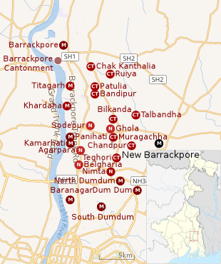 |
| Towns in the southern portion of Barrackpore subdivision in North 24 Parganas district M: municipal city/ town, CT: census town, N: neighbourhood Owing to space constraints in the small map, the actual locations in a larger map may vary slightly |
Location
96% of the population of Barrackpore subdivision (partly presented in the map alongside, all places marked in the map are linked in the full screen map) lives in urban areas. In 2011, it had a density of population of 10,967 per km2 The subdivision has 16 municipalities and 24 census towns.[3] For most of the cities/ towns information regarding density of population is available in the Infobox. Population data is not available for neighbourhoods. It is available for the entire municipal area and thereafter ward-wise.
Police station
New Barrackpore police station is under Barrackpore Police Commissionerate which also has jurisdiction over New Barrackpore municipal areas.[4][5]
Demographics
Population
As per the 2011 Census of India, New Barrackpore had a total population of 76,846, of which 38,239 (50%) were males and 38,607 (50%) were females. Population below 6 years was 5,157. The total number of literates in New Barrackpore was 67,384 (93.99% of the population over 6 years). [6]
As of the 2001 Indian census,[7] New Barrackpore had a population of 83,183. Males constitute 50% of the population and females 50%. In New Barrackpore, 7% of the population is under 6 years of age.The literacy rate is 95.19% where the male literacy rate is 97.66% and female literacy rate is 92.72%.
Kolkata Urban Agglomeration
The following Municipalities, Census Towns and other locations in Barrackpore subdivision were part of Kolkata Urban Agglomeration in the 2011 census: Kanchrapara (M), Jetia (CT), Halisahar (M), Balibhara (CT), Naihati (M), Bhatpara (M), Kaugachhi (CT), Garshyamnagar (CT), Garulia (M), Ichhapur Defence Estate (CT), North Barrackpur (M), Barrackpur Cantonment (CB), Barrackpore (M), Jafarpur (CT), Ruiya (CT), Titagarh (M), Khardaha (M), Bandipur (CT), Panihati (M), Muragachha (CT) New Barrackpore (M), Chandpur (CT), Talbandha (CT), Patulia (CT), Kamarhati (M), Baranagar (M), South Dumdum (M), North Dumdum (M), Dum Dum (M), Noapara (CT), Babanpur (CT), Teghari (CT), Nanna (OG), Chakla (OG), Srotribati (OG) and Panpur (OG).[8]
Infrastructure
As per the District Census Handbook 2011, New Barrackpore municipal town covered an area of 6.89 km2. Amongst the civic amenities it had 120.51 km of roads and open drains. Amongst the educational facilities It had 60 primary schools, 11 middle schools, 10 secondary schools, 8 senior secondary schools, 2 degree colleges in arts/science/commerce and 10 non-formal education centres. Amongst the social, recreational and cultural facilities it had 1 cinema/theatre, 2 auditorium/ community halls, 4 public libraries and 1 reading room. Amongst the commodities manufactured were foam bags, gloves and musical instruments. It had 4 bank branches.[9]
Economy
KMDA
New Barrackpore municipality is included in the Kolkata Metropolitan Area for which the KMDA is the statutory planning and development authority.[10][11]
Transport
There is a railway station at New Barrakpore on the Sealdah-Bangaon line. New Barrackpore is 17 km from Sealdah railway station.[12] It is part of the Kolkata Suburban Railway system.
Education
New Barrackpore has three colleges which are G.C.M. College of Education, Acharya Prafulla Chandra College, Acharya Prafulla Chandra College for Commerce.
The higher secondary schools for boys are New Barrackpore Colony Boys High School, Masunda Boys High School, Kodalia Boys High School, Sahara Boys High School, Satin Sen Nagar Boys High School.
The higher secondary schools for girls are New Barrackpore Colony Girls High School, Masunda Girls High School, Tapati Balika Vidhyabithi, Sahara Girls High School.
Culture
New Barrackpore hosts 'Pushpa Mela' every winter with many fascinating collections of many enterprising florists. 'Kristi' is a community auditorium where cultural events are often held.
Temples
Choto Bot Tala Kali Temples is very famous with the local people. Maa Samsan Kali Temple at Sajirhat is also attended by many devotees. A Kali temple made by Mr.Haripada Biswas attached to New Barrackpore Colony Girl's High School (formerly known Kalibari School) is also very famous.
References
- ↑ Official District Administration site Archived 2007-01-15 at the Wayback Machine.
- ↑ District-wise list of statutory towns Archived 2007-09-30 at the Wayback Machine.
- ↑ "District Statistical Handbook". North 24 Parganas 2013, Tables 2.1, 2.2, 2.4b. Department of Statistics and Programme Implementation, Government of West Bengal. Retrieved 2 May 2018.
- ↑ "District Statistical Handbook". North 24 Parganas 2013, Table 2.1. Department of Statistics and Programme Implementation, Government of West Bengal. Retrieved 11 June 2018.
- ↑ "Barrackpore Police Commissionerate". List of Police Stations with telephone numbers. West Bengal Police. Retrieved 11 June 2018.
- ↑ "2011 Census – Primary Census Abstract Data Tables". West Bengal – District-wise. Registrar General and Census Commissioner, India. Retrieved 7 June 2018.
- ↑ "Census of India 2001: Data from the 2001 Census, including cities, villages and towns (Provisional)". Census Commission of India. Archived from the original on 2004-06-16. Retrieved 2008-11-01.
- ↑ "Provisional Population Totals, Census of India 2011" (PDF). Constituents of Urban Agglomeration Having Population Above 1 Lakh. Census of India 2011. Retrieved 7 June 2018.
- ↑ "District Census Handbook North Twenty Four Parganas, Census of India 2011, Series 20, Part XII A" (PDF). Section II Town Directory, Pages 781-783 Statement I: Growth History, Pages 799-803; Statement II: Physical Aspects and Location of Towns, Pages 791-794; Statement III: Civic and other Amenities, Pages 795-796; Statement IV: Medical Facilities 2009, Pages 803-805 Section: Educational, Recreational and Cultural Facilities. Directorate of Census Operations V, West Bengal. Retrieved 31 May 2018.
- ↑ "Kolkata Metropolitan Development Authoity, Annual Report 2010-11". 1/1 Kolkata Metropolitan Area Map. KMDA. Retrieved 7 June 2018.
- ↑ "Kolkata Metropolitan Development Authority, Annual Report 2010-11". 1 / 2 Role of KMDA. KMDA. Retrieved 7 June 2018.
- ↑ "33811 Sealdah-Bangaon local". Time Table. India Railinfo. Retrieved 15 June 2018.
External links

- New Barrackpore Municipality, website
- New Barrackpore Municipality online