Howrah district
| Howrah district | |
|---|---|
| District of West Bengal | |
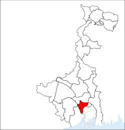 Location of Howrah district in West Bengal | |
| Country | India |
| State | West Bengal |
| Administrative division | Presidency |
| Headquarters | Howrah |
| Government | |
| • Lok Sabha constituencies | Howrah, Uluberia, Serampore - partly |
| • Assembly seats | Bally, Howrah Uttar, Howrah Madhya, Shibpur, Howrah Dakshin, Sankrail, Panchla, Uluberia Purba, Uluberia Uttar, Uluberia Dakshin, Shyampur, Bagnan, Amta, Udaynarayanpur, Jagatballavpur, Domjur |
| Area | |
| • Total | 1,467 km2 (566 sq mi) |
| Population (2011) | |
| • Total | 4,850,029 |
| • Density | 3,300/km2 (8,600/sq mi) |
| Demographics | |
| • Literacy | 83.31 % |
| • Sex ratio | 935 |
| Major highways | NH 16 |
| Average annual precipitation | 1461 mm |
| Website | Official website |
Howrah district (/ˈhaʊrə/) is a district of the West Bengal state in eastern India. Howrah district is one of the highly urbanized area of West Bengal. The urbanized sectors gradually increase the slum populations. The Howrah city called “Glasgow” of India . It has thousands of years of rich heritage in the form of the great Bengali kingdom of Bhurshut. The district is named after its headquarters, the city of Howrah.[1]
Geography
The Howrah district lies between 22°48′ N and 22°12′ N latitudes and between 88°23′ E and 87°50′ E longitudes.[2] The district is bounded by the Hooghly River and the North 24 Parganas and South 24 Parganas districts on the east, on the north by the Hooghly district (Arambagh and Shrirampur sub-divisions), and on the south by Midnapore East district (Tamluk sub-division). On the west Howrah district is bordered by the Ghatal sub-division of Midnapore West district, and partly by the Arambagh sub-division of Hooghly district to the north-west, and the Tamluk sub-division of Midnapore East district to the south-west.
Boundaries of the district are naturally determined by Rupnarayan River on west and south-west, and by Bhagirathi-Hooghly river on east and south-east side. On north side, the boundary is an artificial one except for Bally Canal on north-east and Damodar River on north-west.[3]
Annual normal rainfall is 1461 millimetre per year. Annual maximum temperature varies between 32-39 °C, whereas minimum temperature varies between 8-10 °C.
Demographics
According to the 2011 census Howrah district has a population of 4,841,638,[4] roughly equal to the nation of Singapore[5] or the US state of Alabama.[6] This gives it a ranking of 23rd in India (out of a total of 640).[4] The district has a population density of 3,300 inhabitants per square kilometre (8,500/sq mi) .[4] Its population growth rate over the decade 2001-2011 was 13.31%.[4] Haora has a sex ratio of 935 females for every 1000 males,[4] and a literacy rate of 83.85%.[4]
Total area in Howrah District is 1467 km2. Total population is 4,273,099 as per census 2001 records. 57.91% of the population live in Howrah Sadar subdivision and rest 42.09% live in Uluberia subdivision. Population Density: 2913 per km2.
Divisions
Howrah District is split into the Howrah Sadar subdivision and the Uluberia subdivision. The Howrah Sadar subdivision has 1 municipality and 5 community development (CD) blocks. The Uluberia subdivision has 1 municipality and 9 community development blocks.
Each block consists of a rural area divided into gram panchayats along with census towns.[7] The district has 11 police stations, 157 gram panchayats,[8] and 50 census towns.
| Area | Subdivision | Type | Notes |
|---|---|---|---|
| Howrah Municipality | Howrah Sadar | Municipality | includes the now merged Bally Municipal Corporation |
| Bally Jagachha | Howrah Sadar | CD Block | consists of rural area with 8 gram panchayats and six census towns: Bally (different from Bally municipality), Chakapara, Chamrail, Eksara, Khalia and Jagadishpur Durgapur-Avoynagar1, Durgapur-Avoynagar2, Nischinda |
| Domjur | Howrah Sadar | CD Block | consists of rural area with 18 gram panchayats and sixteen census towns: Domjur, Dakshin Jhapardaha, Khantora, Bhandardaha, Makardaha, Kantlia, Tentulkuli, Salap, Bankra, Nibra, Ankurhati, Bipra Noapara, Kalara, Kesabpur, Natibpur, and Mahiari |
| Panchla | Howrah Sadar | CD Block | consists of rural area with 11 gram panchayats and seven census towns: Bikihakola, Beldubi, Deulpur, Gangadharpur, Jujersha, Jala-Biswanathpur, Banaharishpur, Chara-Panchla, Panchla, Subharara and Sahapur |
| Sankrail | Howrah Sadar | CD Block | consists of rural area with 16 gram panchayats and fourteen census towns: Argari, Dhuilya, Andul, Ramchandrapur, Podara, Panchpara, Hatgachha, Jhorhat, Banipur, Mashila, Sankrail, Manikpur, Nalpur, Raghudebbati and Sarenga |
| Jagatballavpur | Howrah Sadar | CD Block | consists of rural area with 14 gram panchayats and two census town: Mansinhapur and Munshirhat |
| Uluberia | Uluberia | Municipality | |
| Amta I | Uluberia | CD Block | CD block consists of rural area only with 13 gram panchayats |
| Amta II | Uluberia | CD Block | CD block consists of rural area only with 14 gram panchayats |
| Bagnan I | Uluberia | CD Block | CD block consists of rural area with 10 gram panchayats and two census towns: Khalor and Bagnan |
| Bagnan II | Uluberia | CD Block | CD block consists of rural area with 7 gram panchayats and one census town: Naupala |
| Uluberia I | Uluberia | CD Block | CD block consists of rural area only with 9 gram panchayats.The most important village is Bar-Mongrajpur under Hatgacha-1 G.P. |
| Uluberia II | Uluberia | CD Block | CD block consists of rural area with 8 gram panchayats and three census towns: Santoshpur, Balaram Pota and Uttar Pirpur |
| Shyampur I | Uluberia | CD Block | CD block consists of rural area only with 10 gram panchayats |
| Shyampur II | Uluberia | CD Block | CD block consists of rural area only with 8 gram panchayats |
| Udaynarayanpur | Uluberia | CD Block | CD block consists of rural area only with 11 gram panchayats |
Assembly constituencies
The district is divided into 16 assembly constituencies:[9] Sankrail and Uluberia North constituencies will remain reserved for Scheduled Castes (SC) candidates. The division is represented in the Lok Sabha by the Howrah (Lok Sabha constituency), Uluberia (Lok Sabha constituency) and Sreerampur (Lok Sabha constituency).
References
- ↑ Howrah Archived 7 September 2005 at the Wayback Machine.
- ↑ "Geographical location of Howrah district and its headquarters". Archived from the original on 23 December 2008.
- ↑ "Howrah, the second largest city of West Bengal and twin of Kolkata is said to have a rich history that dates back to 500 years". Archived from the original on 20 December 2007.
- 1 2 3 4 5 6 "District Census 2011". Census2011.co.in. 2011. Retrieved 30 September 2011.
- ↑ US Directorate of Intelligence. "Country Comparison:Population". Retrieved 1 October 2011.
Singapore 4,740,737 July 2011 est.
- ↑ "2010 Resident Population Data". U. S. Census Bureau. Archived from the original on 19 October 2013. Retrieved 30 September 2011.
Alabama 4,779,736
- ↑ "Population, Decadal Growth Rate, Density and General Sex Ratio by Residence and Sex, West Bengal/ District/ Sub District, 1991 and 2001". West Bengal. Directorate of census operations. Archived from the original on 28 September 2011. Retrieved 12 October 2008.
- ↑ "Directory of District, Sub division, Panchayat Samiti/ Block and Gram Panchayats in West Bengal, March 2008". West Bengal. National Informatics Centre, India. 19 March 2008. Archived from the original on 25 February 2009. Retrieved 11 November 2008.
- ↑ "General election to the Legislative Assembly, 2001 – List of Parliamentary and Assembly Constituencies" (PDF). West Bengal. Election Commission of India. Archived from the original (PDF) on 11 April 2008. Retrieved 19 November 2008.
External links
| Wikimedia Commons has media related to Howrah district. |
Places adjacent to Howrah district | |
|---|---|
Cities, towns and locations in Howrah District | |
|---|---|
| Cities, municipal and census towns | |
| Locations other than cities and towns | |
| Related topics |
|