Barrackpur Cantonment
| Barrackpur Cantonment | |
|---|---|
| Cantonment Board | |
 Barrackpur Cantonment Location in West Bengal, India  Barrackpur Cantonment Barrackpur Cantonment (India) | |
| Coordinates: 22°47′N 88°29′E / 22.78°N 88.48°ECoordinates: 22°47′N 88°29′E / 22.78°N 88.48°E | |
| Country |
|
| State | West Bengal |
| District | North 24 Parganas |
| Established | 1765 |
| Government | |
| • Type | Cantonment Board |
| Population (2011) | |
| • Total | 17,380 |
| Languages | |
| • Official | Bengali, English |
| Time zone | UTC+5:30 (IST) |
| Lok Sabha constituency | Barrackpore |
| Vidhan Sabha constituency | Noapara |
| Website |
north24parganas |
Barrackpur Cantonment is a cantonment town in Barrackpore subdivision[1] in North 24 Parganas district in the state of West Bengal, India. It is a part of the Kolkata Urban Agglomeration
History
The military station of Barrackpore came into being in 1765. It is the oldest cantonment in India.[2]
Geography
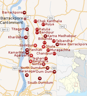 |
| Cities and towns in the southern portion of Barrackpore subdivision in North 24 Parganas district M: municipal city/ town, CT: census town, N: neighbourhood/ administrative location Owing to space constraints in the small map, the actual locations in a larger map may vary slightly |
Location
96% of the population of Barrackpore subdivision (partly presented in the map alongside, all places marked in the map are linked in the full screen map) lives in urban areas. In 2011, it had a density of population of 10,967 per km2 The subdivision has 16 municipalities and 24 census towns.[3]
For most of the cities/ towns information regarding density of population is available in the Infobox. Population data is not available for neighbourhoods. It is available for the entire municipal area and thereafter ward-wise.
Barrackpur Cantonment is bounded by North Barrackpur on the north, Barrackpore on the east and south, and the Hooghly on the west.[4][5]
Police station
Naihati police station under Barrackpore Police Commissionerate has jurisdiction over Naihati municipal area and Barrackpore I CD Block, including Barrackpur Cantonment Board.[6][7]
Demographics
Population
As per the 2011 Census of India, Barrckpore Cantonment Board had a total population of 17,380, of which 8,872 (51%) were males and 8,508 (49%) were females. Population below 6 years was 1,447. The total number of literates in Barrackpore CB was 14,096 (88.47% of the population over 6 years).[8]
As of 2001 India census,[9] Barrackpur Cantonment had a population of 22,014. Males constitute 55% of the population and females 45%. Barrackpur Cantonment has an average literacy rate of 80%, higher than the national average of 59.5%; with 59% of the literates being male and 41% being female. 9% of the population is under 6 years of age.
Kolkata Urban Agglomeration
The following Municipalities, Census Towns and other locations in Barrackpore subdivision were part of Kolkata Urban Agglomeration in the 2011 census: Kanchrapara (M), Jetia (CT), Halisahar (M), Balibhara (CT), Naihati (M), Bhatpara (M), Kaugachhi (CT), Garshyamnagar (CT), Garulia (M), Ichhapur Defence Estate (CT), North Barrackpur (M), Barrackpur Cantonment (CB), Barrackpore (M), Jafarpur (CT), Ruiya (CT), Titagarh (M), Khardaha (M), Bandipur (CT), Panihati (M), Muragachha (CT) New Barrackpore (M), Chandpur (CT), Talbandha (CT), Patulia (CT), Kamarhati (M), Baranagar (M), South Dumdum (M), North Dumdum (M), Dum Dum (M), Noapara (CT), Babanpur (CT), Teghari (CT), Nanna (OG), Chakla (OG), Srotribati (OG) and Panpur (OG).[10]
Healthcare
North 24 Parganas district has been identified as one of the areas where ground water is affected by arsenic contamination.[11]
See also
References
- ↑ District-wise list of statutory towns Archived August 9, 2007, at the Wayback Machine.
- ↑ "Danapur cantt celebrates 250 yrs".
- ↑ "District Statistical Handbook". North 24 Parganas 2013, Tables 2.1, 2.2, 2.4b. Department of Statistics and Programme Implementation, Government of West Bengal. Retrieved 2 May 2018.
- ↑ "District Census Handbook North Twenty Four Parganas, Census of India 2011, Series 20, Part XII A" (PDF). Map of Barrackpore I CD Block on Page 365. Directorate of Census Operations, West Bengal. Retrieved 27 June 2018.
- ↑ "District Census Handbook North Twenty Four Parganas, Census of India 2011, Series 20, Part XII A" (PDF). Map of Barrackpore II CD Block on Page 379. Directorate of Census Operations, West Bengal. Retrieved 27 June 2018.
- ↑ "District Statistical Handbook". North 24 Parganas 2013, Tables 2.1, 2.2, 2.4b. Department of Statistics and Programme Implementation, Government of West Bengal. Retrieved 11 June 2018.
- ↑ "Barrackpore Police Commissionerate". List of Police Stations with telephone numbers. West Bengal Police. Retrieved 11 June 2018.
- ↑ "2011 Census – Primary Census Abstract Data Tables". West Bengal – District-wise. Registrar General and Census Commissioner, India. Retrieved 7 June 2018.
- ↑ "Census of India 2001: Data from the 2001 Census, including cities, villages and towns (Provisional)". Census Commission of India. Archived from the original on 2004-06-16. Retrieved 2008-11-01.
- ↑ "Provisional Population Totals, Census of India 2011" (PDF). Constituents of Urban Agglomeration Having Population Above 1 Lakh. Census of India 2011. Retrieved 7 June 2018.
- ↑ "Groundwater Arsenic contamination in West Bengal-India (19 years study )". Groundwater arsenic contamination status of North 24-Parganas district, one of the nine arsenic affected districts of West Bengal-India. SOES. Archived from the original on 27 September 2007. Retrieved 2007-08-24.
External links
