Taltala
| Taltala | |
|---|---|
| Neighbourhood in Kolkata (Calcutta) | |
 | |
| Country |
|
| State | West Bengal |
| City | Kolkata |
| KMC Ward | 52, 53, 62 |
| Metro Station | Esplanade |
| Parliamentary constituency | Kolkata Uttar |
| Assembly constituency | Chowranghee |
| Elevation | 36 ft (11 m) |
| Time zone | UTC+5:30 (IST) |
| PIN | 700014 |
| Area code(s) | +91 33 |
Taltala (also spelt Taltola, archaic spelling Taltollah) is a neighbourhood in central Kolkata, earlier known as Calcutta, in the Indian state of West Bengal. One of the old neighbourhoods of the metropolis, it has a police station.[1]
Etymology
History
According to H. E. A. Cotton Taltala was chiefly peopled by Bihari Muslim khalasis and lascars. Wellesley Street (renamed Rafi Ahmed Kidwai Road) is described as a ‘fine broad thoroughfare’, along the course of which is situated Wellesley Square (renamed Haji Mohd. Mohsin Square). To the north of it is the Madrasa.[3]
In 1758, one year after their decisive win in Battle of Plassey, the British East India Company commenced construction of the new Fort William in the center of the village Gobindapur. The inhabitants of the village were compensated and provided with land in Taltala, Kumortuli and Shovabazar.[4]
Although a predominantly Muslim locality, its early Hindu settlers included Durga Charan Banerjea, father of Surendranath Banerjea.[2] Muslims have been living in the area since the early 19th century, and the earliest inhabitants were mainly Bengali Muslims, though Bihari Muslim settlers began arriving in a flood since 1870-1880 and more so since the 1980s.
In 1888, one of the 25 newly organized police section houses was located in Taltala.[5]
Geography
Location
While Ward Nos 52 and 53 of Kolkata Municipal Corporation are under the Taltala Police Station, and are part of Taltala, ward no. 62, broadly under Park Street Police Station but a part of it is under Taltala police station, is also a part of Taltala. The neighbourhood is bound by Dharmatala in the north, Entally in the east, Park Street neighbourhood in the south and Janbazar and Chowringhee in the west.[6] Great celebrities of Taltala are Surendranath Banerjee, Durga Charan Banerjee, Jnanendra Nath Mukherjee, Hirendranath Mukherjee, Rezaul Karim, Dr. Moni Biswas, Dr Tamiz Khan, Narendranath Sen, Tripura sankar Sensastry, Sudam Banerjee, Nilmoni Mukherjee, Bijoy Singh Nahar, Benjamin Gomes, Syed Badruddoja and so on
Police district
Taltala police station is part of the Central division of Kolkata Police. Located at 4, Taltala Lane, Kolkata-700014, it has jurisdiction over the police district which is bordered in the north from the north-east corner of the junction of Lenin Sarani (old Dharmatala Street), Nirmal Chandra Street (old Wellington Street) and Rafi Ahmed Kidwai Road (old Wellesly Street), thence east-ward along the northern limit of Lenin Sarani to Acharya Jagadish Chandra Bose Road up to the north-west corner of the junction of Lenin Sarani and Acharya Jagadish Chandra Bose Road, thence crossing the Acharya Jagadish Chandra Bose Road east-ward up to the north-east corner of the junction of Lenin Sarani and Acharya Jagadish Chandra Bose Road. On the east, it is bordered from the north-east corner of the junction of Lenin Sarani (old Dharmatala Street) and Acharya Jagadish Chandra Bose Road, thence south ward along the eastern limit of Acharya Jagadish Chandra Bose Road, up to the north-east corner of the junction of Alimuddin Street and Acharya Jagadish Chandra Bose Road. On the south, it is bordered from the north-east corner of the junction of Alimuddin Street and Acharya Jagadish Chandra Bose Road, thence crossing Acharya Jagadish Chandra Bose Road west ward up to the north-west corner of the junction of Acharya Jagadish Chandra Bose Road and Alimuddin Street thence by the northern limit of Alimuddin Street up to the north-east corner of the junction of Alimuddin Street and Rafi Ahmed Kidwai Road (old Wellesly Street). On the west, it is bordered from the north east corner of the junction of Rafi Ahmed Kidwai Road (old Wellesly Street) and Alimuddin Street, thence north ward by the eastern limit of Rafi Ahmed Kidwai Road up to the south east corner of the junction of Lenin Sarani and Rafi Ahmed Kidwai Road, thence crossing Lenin Sarani North ward up to the north east corner of the junction of Lenin Sarani (old Dharmatala St.), Nirmal Chunder Street and Rafi Ahmed Kidwai Road.[7]
Taltala Women police station, located at the same address as above, covers all police districts under the jurisdiction of the Central division i.e. Bowbazar, Burrabazar, Girish Park, Hare Street, Jorasanko, Muchipara, New Market, Taltala and Posta.[7]
Demographics
Taltala police station area spread over ward nos. 52 and 53 of Kolkata Municipal Corporation had a total population of 53,348 in the 2001 census, of which 24,121 were males and 19,227 were females. Ward No. 62 had a population of 45,817, out of which 28,019 were males and 17,798 were females.[8] The locality is largely Urdu-speaking. Urdu-speaking Muslims form 85% of the population. Taltala has its own literary Bengali journal named TALTALA DARPAN EDITOR: Dr Sankar Kumar Nath,professionally an Oncologist but having talents in singing,painting,astronomy,writing history,poems.
Important landmarks
- Madrasa 'Aliya on Rafi Ahmed Kidwai Street
- Headquarters of Communist Party of India (Marxist) on Alimuddin Street.
- Taltal Public Library, (Oldest existing Public library of Calcutta established in 1882), 12B, Taltala Library Row, Calcutta - 14.
- Taltala High School, established in 1910.
See also
References
- ↑ "Taltala Police Station". Kolkata Police. Archived from the original on June 8, 2007. Retrieved 2008-01-16.
- 1 2 Nair, P. Thankappan, The Growth and Development of Old Calcutta, in Calcutta, the Living City, Vol I, edited by Sukanta Chaudhuri, pp. 11-18, Oxford University Press, ISBN 978-0-19-563696-3.
- ↑ Cotton, H.E.A., Calcutta Old and New, 1909/1980, p. 220, General Printers and Publishers Pvt. Ltd.
- ↑ Cotton, H.E.A, p 72
- ↑ Nair, P.Thankappan, The Growth and Development of Old Calcutta, in Calcutta, the Living City, Vol. I, pp. 18-19, Edited by Sukanta Chaudhuri, Oxford University Press, 1995 edition.
- ↑ Detail Maps of 141 Wards of Kolkata, D.R.Publication and Sales Concern, 66 College Street, Kolkata – 700073
- 1 2 "Kolkata Police". Central Division. KP. Retrieved 9 March 2018.
- ↑ "Provisional Population Totals, Table 4". Population, Decadal Growth Rate, Density and General Sex Ratio by Residence and Sex, West Bengal/ District/ Sub District, 1991 and 2001. Census Commission of India. Retrieved 2007-10-10.
Images
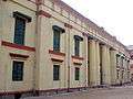 Calcutta Madrsah College established in 1780
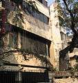 Muzaffar Ahmed Bhawan, CPI(M) party office at 31 Alimuddin Street
 Muslim Institute
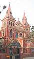 St. Teresa of Avila Church on Acharya Jagadish Chandra Bose Road