Gangadharpur
| Gangadharpur | |
|---|---|
| Census Town | |
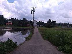 Gangadharpur Street View | |
 Gangadharpur Location in West Bengal, India  Gangadharpur Gangadharpur (India) | |
| Coordinates: 22°46′N 88°13′E / 22.76°N 88.22°ECoordinates: 22°46′N 88°13′E / 22.76°N 88.22°E | |
| Country |
|
| State | West Bengal |
| District | Hooghly |
| Nearest city | Serampore |
| Government | |
| • Type | Panchayati raj (India) |
| • Body | Gangadharpur gram panchayat |
| Area | |
| • Total | 2.19 km2 (0.85 sq mi) |
| Elevation | 14 m (46 ft) |
| Population (2011) | |
| • Total | 7,862 |
| • Density | 3,600/km2 (9,300/sq mi) |
| Languages | |
| • Official | Bengali, English |
| Time zone | UTC+5:30 (IST) |
| PIN | 712306 |
| Telephone code | 03212 |
| ISO 3166 code | IN-WB |
| Vehicle registration | WB-16 and WB-18 |
| Sex ratio | 979 females/1000 males ♂/♀ |
| Literacy rate | 83.52 % |
| Lok Sabha constituency | Serampore |
| Vidhan Sabha constituency | Chanditala |
| Website | Gangadharpur |
Gangadharpur is a census town and a gram panchayat in Chanditala I CD Block in Srirampore subdivision of Hooghly district in the state of West Bengal, India. It is under Chanditala police station.[1]
Geography
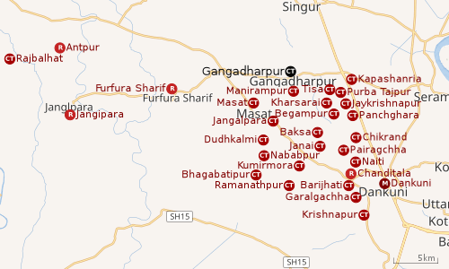 |
| Cities and towns in Chanditala I, Chanditala II and Jangipara CD Blocks in Srirampore subdivision in Hooghly district M: municipal city/ town, CT: census town, R: rural/ urban centre, Owing to space constraints in the small map, the actual locations in a larger map may vary slightly |
Location
Gangadharpur is located at: 22°46′N 88°13′E / 22.76°N 88.22°E[2] It has an average elevation of 14 metres (46 feet). It is located in the Chanditala–I community development block under the Srirampore subdivision of the Hooghly district. Chanditala police station serves this town. There is a small river its local name is Kana Nadi "(Bn:কানা নদী)" (blind river).
It is 26 km from district headquarters Hooghly. 30 km from state capital Kolkata.[3]
Gangadharpur, Manirampur, Masat, Jangalpara, Dudhkalmi, Nababpur, Bhagabatipur, Kumirmora and Ramanathpur form a cluster of census towns in Chanditala I CD Block.[4]
Urbanisation
Srirampore subdivision is the most urbanized of the subdivisions in Hooghly district. 73.13% of the population in the subdivision is urban and 26.88% is rural. The subdivision has 6 municipalities and 34 census towns. The municipalities are: Uttarpara Kotrung Municipality, Konnagar Municipality, Serampore Municipality, Baidyabati Municipality, Rishra Municipality and Dankuni Municipality. Amongst the CD Blocks in the subdivision, Uttarapara Serampore (census towns shown in a separate map) had 76% urban population, Chanditala I 42%, Chanditala II 69% and Jangipara 7% (census towns shown in the map above).[5][6]All places marked in the map are linked in the larger full screen map.
Gram panchayat
Villages and census towns in Gangadharpur gram panchayat are: Bankrishnapur, Gangadharpur, Malipukur and Manirampur.[7]
Gangadharpur has an area of 2.19 km2.
Market: Ganngadharpur Bazar, Hajaghata, Manirampur.
Demographics
As of 2011 India census,[8] Gangadharpur had a population of 7862. Males constitute 51% of the population and females 49%. Gangadharpur has an average literacy rate of 83.5%, higher than the state average of 76.26%; with 87.72% of the literates being male and 79.27% being female. 9% of the population is under 6 years of age.
Festivals
Like other parts of West Bengal, Durga Puja is the biggest festival of Gangadharpur . Kali Puja is one of the famous festivals celebrated in Gangadharpur. Also, Lakshmi Puja, Viswakarma Puja, Saraswati Puja, Poila Boisakh-Ganesh Puja, kartik Puja, Dol Yatra are widely celebrated at Gangadharpur and Boisakhi mela, Charok, etc.
Transport
The nearest railway station, Baruipara railway station, on the Howrah-Bardhaman chord line is 26 km from Howrah and is a part of the Kolkata Suburban Railway system.[9][10]
The main road is 31 Number Road It is the main artery of the town and it is connected with NH 19 (old numbering NH 2) and Grand Trunk Road.[10]
There is 31 Number bus service Jangipara bus stand to Serampore bus stand via Sehakhala, Banmalipur, Gangadharpur, Baruipara, Bora. Another road renovated under Gangadharpur-Singur Road is connected to SH 2. There is auto and trecker service Singur to Masat via Gangadharpur. Gangadharpur-Jangalpara Road is connected SH 15. There is auto and trecker service Baruipara to Masat via Ganagadharpur.
Healthcare
Gangdharpur has a Primary Health Centre with 10 beds.[11][12]
Gangadharpur picture gallery
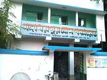 Gangadharpur gram panchayat
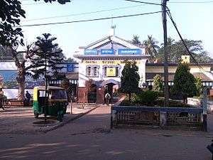 Baruipara railway station is 1.5 km from Gangadharpur
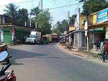 Gangadharpur Bazaar, 31 Number Road, Hooghly
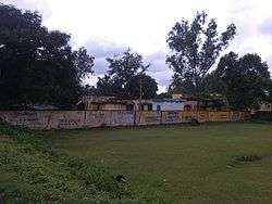 Gangadharpur Health Centre
References
- ↑ "Mouza Information". Land & Land Reforms Department, Government of West Bengal.
- ↑ "Google maps location of Gangadharpur". Google maps. Retrieved 2015-12-30.
- ↑ "Hugli district census handbook" (PDF). Retrieved 27 February 2016.
- ↑ "Census of India 2011, West Bengal: District Census Handbook, Hooghly" (PDF). Map of Chanditala I CD Block, page 649. Directorate of Census Operations, West Bengal. Retrieved 4 October 2018.
- ↑ "District Statistical Handbook 2014 Hooghly". Table 2.2, 2.4(a). Department of Statistics and Programme Implementation, Government of West Bengal. Retrieved 3 October 2018.
- ↑ "C.D. Block Wise Primary Census Abstract Data(PCA)". 2011 census: West Bengal – District-wise CD Blocks. Registrar General and Census Commissioner, India. Retrieved 3 October 2018.
- ↑ "Bankrishnapur". Indian Village Directory. Retrieved 12 October 2018.
- ↑ "Census of India 2011: Data from the 2011 Census, including cities, villages and towns (Provisional)". Census Commission of India.
- ↑ "36811 Howrah Bardhaman Local (via Chord)". indiarailinfo. Retrieved 6 October 2018.
- 1 2 Google maps
- ↑ "Health & Family Welfare Department". Health Statistics. Government of West Bengal. Retrieved 4 October 2018.
- ↑ "Hooghly.gov.phc".
| Wikimedia Commons has media related to Gangadharpur. |
Places adjacent to Gangadharpur | ||||||||||
|---|---|---|---|---|---|---|---|---|---|---|
| ||||||||||