Bhowanipore
| Bhawanipur | |
|---|---|
| Neighbourhood in Kolkata (Calcutta) | |
| Country |
|
| State | West Bengal |
| City | Kolkata |
| District | Kolkata |
| Metro Line 1 | Rabindra Sadan, Netaji Bhavan and Jatin Das Park |
| Municipal Corporation | Kolkata Municipal Corporation |
| KMC wards | 70, 71, 72, 73 |
| Elevation | 36 ft (11 m) |
| Population | |
| • Total | For population see linked KMC ward pages |
| Time zone | UTC+6:30 (IST) |
| PIN | 700 020 |
| Area code(s) | +91 33 |
| Lok Sabha constituency | Kolkata Dakshin |
| Vidhan Sabha constituency | Bhabanipur |
Bhowanipore or Bhabanipur is a neighbourhood of South Kolkata in Kolkata district, West Bengal, India.
History
The East India Company obtained from the Mughal emperor Farrukhsiyar, in 1717, the right to rent from 38 villages surrounding their settlement. Of these 5 lay across the Hooghly in what is now Howrah district. The remaining 33 villages were on the Calcutta side. After the fall of Siraj-ud-daulah, the last independent Nawab of Bengal, it purchased these villages in 1758 from Mir Jafar, and reorganised them. These villages were known en-bloc as Dihi Panchannagram and Bhowanipore was one of them. It was considered to be a suburb beyond the limits of the Maratha Ditch.[1][2][3]
Bhowanipore existed as a dihi in 1765 and also absorbed a part of Dihi Chakraberia. The construction of Harish Mukherjee Road and Lansdowne Road (now Sarat Bose Road) and extension of Hazra Road to Kalighat, opened up the area at the beginning of the 20th century.[4] Aritsans played a role in developing the neighbourhood and making it a populous native place. The kansaris (braziers), the shankharis (conch workers) and the telis (oil pressers) - all had their paras. The goods were sold in pattis. Along with these artisans, Indian lawyers, including the most brilliant among them, flocked to Bhowanipore, as the Sadar Diwani Adalat, the highest appellate court in those days, had shifted to the old Military Hospital Building here, and the District Judge's court was in nearby Alipore.[4][5]
In 1888, one of the 25 newly organized police section houses was located in Bhowanipore.[4]
When the Bengal Renaissance started taking roots in 19th century Calcutta, it was initially limited to the predominantly Hindu 'Indian town' stretching north and north-east from the fringes of Burrabazar, with a somewhat later extension to south and south-east of the 'European town' to Bhowanipore, and some decades later to Ballygunge, which was then developing as a suburb.[6]
In the first half of the 20th century, “in the milieu of relative urban prosperity... Calcutta’s rich citizens – those connected with jute, coal, tea, other industries, trade, money-lending and rentier income from urban property – did fabulously well for themselves.” Many of the mansions in Ballygunge, Bhowanipore and Alipore were built by the city’s Bengali and new Marwari elite who wanted to move from the “dirtier sections of north Calcutta to the more fashionable areas in the south”.[7]
Again, it was in the first half of the 20th century that with the implementation of the Area Improvement Programme of Calcutta Improvement Trust Bhowanipore, an old residential suburb was upgraded to modern standards of town planning.[8]
Notable residents
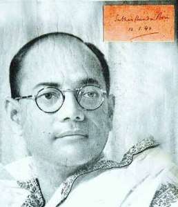
- Subhas Chandra Bose, one of the frontline Freedom Fighters of British India, founder of Forward Bloc and the Indian National Army
- Hemant Kumar, famous singer, composer, director and producer, lived near Kansari Para in his youth and attended Mitra Institution school of Bhowanipore area.
- Uttam Kumar, Matinee Idol, Mahanayak, the first person to be Awarded a National Award for Acting, Director, Producer, Singer, and Composer. Immortal Hero of Bengali Movies
- Anil Kumar Gain, prominent mathematician from the University of Cambridge, Fellow of the Royal Society
- Satyajit Ray, world-renowned film-maker, composer and author
- Deshbandhu Chittaranjan Das, renowned barrister and president of Swaraj Party
- Brajendranath De, commissioner of Burdwan
- Tarun Kumar, Versatile Actor, Brother of Uttam Kumar
- Ashutosh Mookerjee, vice-chancellor of the University of Calcutta
- Shyama Prasad Mookerjee, founder of Jan Sangh and first union industry minister of India
- Premendra Mitra, Author and Poet
- Siddhartha Shankar Ray, former Chief Minister of West Bengal, Barrister
- Bijon Bhattacharya, eminent theater artist, director and famous Bengali play writer, also husband of eminent international award-winning social worker and writer Smt.Mahasweta Devi.
- Ranjit Mallick, Bengali film actor.
Geography
Location
It is located south of the Lower Circular Road (now A.J.C. Bose Road). It is bounded by Lansdowne Road (presently Sarat Bose Road) to the east, Hazra Road to the south and Tolly Nullah to the west. It consists of well-known and posh localities like Elgin Road, Gokhale Road, Woodburn Park, Bakulbagan Road, Harish Mukherjee Road, Townshend Road and parts of Chakraberia and Lansdowne.
Police district
Bhowanipur police station is part of the South division of Kolkata Police. Located at 42, Shyama Prasad Mukherjee Road, Kolkata-700026, it has jurisdiction over the police district which is bordered on the north from the south-east corner of the junction of AJC Bose Road (old Lower Circular Road) and D L Khan Road (old Bhowanipore Road) and then eastward by the southern limits of AJC Bose Road to Sarat Bose Road (old Lansdowne Road), the crossing Sarat Bose Road, up to the south-east corner of the junction of AJC Bose Road and Sarat Bose Road.[9]
On the east, it is bordered from the south-east corner of the junction of AJC Bose Road (old Lower Circular Road) and Sarat Bose Road (old Lansdowne Road) and then southward by the eastern limits of Sarat Bose Road up to the north-east corner of the junction of Hazra Road and Sarat Bose Road.[9]
On the south, it is bordered from the north-east corner of the junction of Hazra Road and Sarat Bose Road, after crossing Sarat Bose Road by the northern limits of Hazra Road up to the north-east corner of the junction of Hazra Road and Ashutosh Mukherjee Road, then crossing Ashutosh Mukherjee Road again by the northern limits of Hazra Road up to the north-east corner of the junction of Hazra Road and Harish Mukherjee Road.[9]
On the west it is bordered from the north-east corner of the junction of Hazra Road and Harish Mukherjee Road, then northwards by the eastern limits of Harish Mukherjee Road up to the north-east corner of the junction of Sambhu Nath Pandit Street and Harish Mukherjee Road, then crossing Harish Mukherjee Road, westward by the northern limits of Sambhu Nath Pandit Street up to the north-east corner of the junction of Sambhu Nath Pandit Street and D. L. Khan Road, and then northwards by the eastern limits of D. L. Khan Road up to the south-east corner of the junction of AJC Bose Road and D. L. Khan Road.[9]
Tollygunge Women's police station has jurisdiction over all the police districts in the South Division, i.e. Park Street, Shakespeare Sarani, Alipore, Hastings, Maidan, Bhowanipore, Kalighat, Tollygunge, Charu Market, New Alipur and Chetla.[9]
Places of interest
- Netaji Bhawan, Elgin Road
- Sir Ashutosh Mukherjee's house on Ashutosh Mukherjee Road
- South Club, Kolkata's premier Tennis club
- Satyajit Ray's rented house on Bishop Lefroy Road
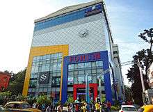
- The Forum Mall, Elgin Road
- Puddapukur Swimming Centre, Lansdowne Road
- Uttam Kumar's house at Girish Mukherjee Road
- Ramkrishna Math- Gadhadhar Ashram on Harish Chatterjee Street
- Swami Narayan Mandir, Chakraberia Road South.
- Laxmi Narayan Mandir, Lansdown Road.
- Northern Park, a historic park where many Freedom Fighters addressed their meetings
- Bhowanipore cemetery, a Christian cemetery having graves of WWII fighters.
- Harish Park.
- Bramho Samaj Temple. Barhmo Somaj, founded by Raja Ram Mohan Roy & patronized by many elite including Gurudev Rabindranath Tagore during that time.
Demographics
Business opportunities brought many Gujaratis to Calcutta about a century back and they opted to stay in the Lansdowne-Chakraberia-Puddapukur belt of Bhowanipore. The railways, the jute mills and the shipping industry brought in many Punjabis to Calcutta. The Harish Mukherjee Road area of Bhowanipore and Dunlop (in north Kolkata) were the biggest pockets of Punjabi settlement. With declining economic opportunities many of both the communities are leaving Kolkata.[10][11] Writing about the Bhabanipur (Vidhan Sabha constituency), from where the West Bengal chief minister, Mamata Banerjee, contests, Hindustan Times said, “The constituency has a sizable population of Sikhs and Gujaratis. However, it is dominated by middle-class Bengalis.” [12]
For language and religion census data, available at the district level, see Kolkata district.
Economy
Residential property
As of 2018, the price of residential property in Ballygunge is amongst the neighbourhoods with high prices in Kolkata, and the price has almost doubled in the last decade.[13]
Markets
The Jadu Babu's Bazaar on Asutosh Mukherjee Road was the heart of south Kolkata before Gariahat even developed. It is still the major market for the locality.
Bhowanipore also has its share of 21st century commercialization sweeping Kolkata. It is home to Kolkata's first mall-cum-multiplex - The Forum mall on Elgin Road with its Inox multiplex.
Commercial centres
Many big companies have their head office in Bhowanipore, like Exide Industries Limited, Tata Tea Limited and Phillips India Limited to name a few. The head office of Automobile Association Of Eastern India is also located in this area.
Transport
Bhowanipore sits on some of the most important roads of Kolkata and till date the most accessible residential area of South Kolkata from its city-centre,and is excellently served by all buses plying through the southern part of the city.
The Kolkata Metro serves the area with the Rabindra Sadan, Netaji Bhavan and Jatin Das Park stations.
Culture
Bhowanipore was also known as the Cinema Para, or the locality of the city which boasted of a string of cinema halls. The stretch started with Purna near Jadu Babu's Bazaar, and was followed up by Bharati, Indira, Bijoli, Basusree, Kalika, and Ujjwala, right up to the recesses of the Kalighat Temple. They were primarily famous for their screenings of Bengali, English and Hindi movies. However, due to the lack of patronage and drying up of the Bengali film box office in the mid 90s, and the first decade of the 2000s, most of these halls have been closed down. Basusree, Indira and Bijoli are still operational, though the condition is not that well of, Bharati, Kalika, and Ujjwala have been demolished to make way for multi storied buildings that host malls, educational institutes, and marriage halls. Purna has been closed down for more than a decade now, and there is little hope that it will be opened again.
The area also boasts of the 23 Palli Durga Mandir, a small yet beautiful Temple which houses a grand Ashta Dhaatu Murti of Durga, and nearby is the world-famous Kalighat Kali Temple, and the Nakuleshwar Bhairav Temple, considered as one of the holiest of the holies in Hindu religion.
Healthcare
- Chittaranjan National Cancer Institute
- Chittaranjan Sishu sadan
- Ramkrishna Mission Seva Pratishtan
- Ramrick Hospital
- SSKM Hospital
- Sambhunath Pandit Hospital
- Guru Tegh Bahadur M.S.C Hospital[14]
Education
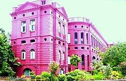
- Asutosh College, S. P. Mukherjee Road
- Bhawanipur Education Society College, Elgin Road
- Beltala Girls' School, Beltala Road
- Gokhale Memorial Girls' School, Harish Mukherjee Road
- Children's Hut, a Kindergarten school, Harish Mukherjee Road
- Bhawanipur Gujarati Balmandir
- J. J. Ajmera High School, Heysham Road
- South Suburban School (Main),Subarban School Rd.
- Julien Day School, Elgin Road and Ramesh Mitra Road.
- United Missionary Girls' High School, Mukherjee Road.
- Mitra Institution, Harish Mukherjee Road
- St. John's Diocesan Girls' Higher Secondary School
- Hartley's High/Pvt. School, Sarat Bose Road
- Cathedral Mission High School, Elgin Road
- Chakraberia School
- South Calcutta Girls' School
- South Calcutta Girls' College
- Khalsa High School
- IPGME&R and SSKM Hospital, Acharya Jagadish Chandra Bose Road
- Acharya Jagadish Chandra Bose College
- Adarsh Hindi High School, Boys' & Girls', Rammoy Road. Bhowanipore
- Ramrick Institution
- Sir Ramesh Mitter Girls' High School
Sports
A club in the name of " Bhowanipore Club" founded by Nani Mitra stands at the entrance of the Maidan near the Rani Rashmani Statue and presently managed by the " Sangbad Pratidin" group.
References
- ↑ "District Census Handbook Kolkata, Census of India 2011, Series 20, Part XII A" (PDF). Pages 6-10: The History. Directorate of Census Operations, West Bengal. Retrieved 20 February 2018.
- ↑ Cotton, H.E.A., Calcutta Old and New, first published 1909/reprint 1980, pages 103-4 and 221, General Printers and Publishers Pvt. Ltd.
- ↑ Nair, P.Thankappan, The Growth and Development of Old Calcutta, in Calcutta, the Living City, Vol. I, pp. 14-15, Edited by Sukanta Chaudhuri, Oxford University Press, 1995 edition.
- 1 2 3 Nair, P.Thankappan, The Growth and Development of Old Calcutta, in Calcutta, the Living City, Vol. I, pp. 15,18-19, Edited by Sukanta Chaudhuri, Oxford University Press, 1995 edition.
- ↑ Cotton, H.E.A., Calcutta Old and New, first published 1909/reprint 1980, page 223, General Printers and Publishers Pvt. Ltd.
- ↑ Sarkar, Sumit, "Calcutta and the 'Bengal Renaissance'"", in Calcutta, the Living City, Vol. I, p. 100, Edited by Sukanta Chaudhuri, Oxford University Press, 1995 edition.
- ↑ Goswami, Omkar, “Calcutta’s Economy 1918-1970 The Fall from Grace”, “Calcutta, The Living City” Vol II, Edited by Sukanta Chaudhuri, Page 93, First published 1990, 2005 edition, ISBN 019 563697
- ↑ Chatterjee, Monideep, "Town Planning in Calcutta: Past, Present and Future", “Calcutta, The Living City” Vol II, Edited by Sukanta Chaudhuri, Page 141, First published 1990, 2005 edition, ISBN 019 563697
- 1 2 3 4 5 "Kolkata Police". South Division – Bhawanipur police station. KP. Retrieved 5 March 2018.
- ↑ "People in Pockets". Gujarat Capital and Flavours of Punjab. The Telegraph, 16 March 2008. Retrieved 5 March 2018.
- ↑ "Gujaratis tread the exit route". The Telegraph, 30 April 2003. Retrieved 5 March 2018.
- ↑ "Bhowanipore: Mamata Banerjee's constituency is Trinamool's citadel". Hindustan Times, 20 April 2016. Retrieved 5 March 2018.
- ↑ "Property Rates in Kolkata". magicbricks. Retrieved 5 March 2018.
- ↑ Gurh Tegh Bahadur Medical Service Centre Hospital Archived December 31, 2013, at the Wayback Machine.
External links
![]()