Onda (community development block)
| Onda | |
|---|---|
| Community development block | |
 Onda Location in West Bengal, India | |
| Coordinates: 23°08′N 87°12′E / 23.13°N 87.20°ECoordinates: 23°08′N 87°12′E / 23.13°N 87.20°E | |
| Country |
|
| State | West Bengal |
| District | Bankura |
| Government | |
| • Type | Community development block |
| Area | |
| • Total | 502.46 km2 (194.00 sq mi) |
| Elevation | 74 m (243 ft) |
| Population (2011) | |
| • Total | 252,984 |
| • Density | 500/km2 (1,300/sq mi) |
| Languages | |
| • Official | Bengali, English |
| Time zone | UTC+5:30 (IST) |
| PIN | 722144 (Onda) |
| Telephone/STD code | 03244 |
| ISO 3166 code | IN-WB |
| Vehicle registration | WB-67, WB-68 |
| Literacy | 65.82% |
| Lok Sabha constituency | Bishnupur |
| Vidhan Sabha constituency | Onda |
| Website |
bankura |
Onda is a community development block that forms an administrative division in Bankura Sadar subdivision of Bankura district in the Indian state of West Bengal.
History
From Bishnupur kingdom to the British Raj
From around 7th century AD till around the advent of British rule, for around a millennium, history of Bankura district is identical with the rise and fall of the Hindu Rajas of Bishnupur. The Bishnupur Rajas, who were at the summit of their fortunes towards the end of the 17th century, started declining in the first half of the 18th century. First, the Maharaja of Burdwan seized the Fatehpur Mahal, and then the Maratha invasions laid waste their country.[1]
Bishnupur was ceded to the British with the rest of Burdwan chakla in 1760. In 1787, Bishnupur was united with Birbhum to form a separate administrative unit. In 1793 it was transferred to the Burdwan collectorate. In 1879, the district acquired its present shape with the thanas of Khatra and Raipur and the outpost of Simplapal being transferred from Manbhum, and the thanas of Sonamukhi, Kotulpur and Indas being retransferred from Burdwan. However, it was known for sometime as West Burdwan and in 1881 came to be known as Bankura district.[1]
Geography
Onda is located at 23°08′N 87°12′E / 23.13°N 87.20°E.
Onda CD Block is located in the central part of the district. It belongs to the uneven lands/ hard ring rock area. The soil is laterite red and hard beds are covered with scrub jungle and sal wood.[2]
Onda CD Block is bounded by Bankura II CD Block on the north, Bishnupur CD Block on the east, Taldangra CD Block on the south and Indpur and Bankura I CD Blocks on the west.
It is located 20 km from Bankura, the district headquarters.
Onda CD Block has an area of 502.46 km2. It has 1 panchayat samity, 15 gram panchayats, 185 gram sansads (village councils), 291 mouzas and 271 inhabited villages. Onda police station serves this block.[3] Headquarters of this CD Block is at Onda.[4]
Gram panchayats of Onda block/ panchayat samiti are: Chingani, Churamanipur, Kalyani, Kantaberia, Lodona, Majdiha, Medinipur, Nakaijuri, Nikunjapur, Onda I, Onda II, Punisole, Ramsagar, Ratanpur and Santore.[5]
Demographics
Population
As per the 2011 Census of India Onda CD Block had a total population of 252,984, all of which were rural. There were 129,248 (51%) males and 123,736 (49%) females. Population below 6 years was 33,274. Scheduled Castes numbered 83,933 (33.18%) and Scheduled Tribes numbered 12,443 (4.92%).[6]
As per 2001 census, Onda block had a total population of 219,845, out of which 112,429 were males and 107,416 were females. Onda block registered a population growth of 15.06 per cent during the 1991-2001 decade. Decadal growth for the district was 15.15 per cent.[7] Decadal growth in West Bengal was 17.84 per cent.[8]
Large villages (with 4,000+ population) in Onda CD Block are (2011 census figures in brackets): Onda (5,933), Aguri Band Punisol (22,193), Nutangram (4,077) and Chingani (4,004).[6]
Other villages in Onda CD Block are (2011 census figures in brackets): Majdiha (1,173), Churamanipur (992), Medinipur (2,662), Lodna (3,072), Kalyani (1,632), Ratanpur (1,822), Santor (1,739), Nikunjapur (2,239), Bahulara (1,124) and Ramsagar (712).[6]
Literacy
As per the 2011 census the total number of literates in Onda CD Block was 144,618 (65.82% of the population over 6 years) out of which males numbered 85,546 (75.44% of the male population over 6 years) and females numbered 60,072 (55.81%) of the female population over 6 years). The gender disparity (the difference between female and male literacy rates) was 19.63%.[6]
As per the 2011 census, literacy in Bankura district was 70.26%, up from 63.44 in 2001 and 52.00% in 1991.[9] Literacy in West Bengal was 77.08% in 2011.[10] Literacy in India in 2011 was 74.04%.[10]
See also – List of West Bengal districts ranked by literacy rate
| Literacy in CD Blocks of Bankura district |
|---|
| Bankura Sadar subdivision |
| Saltora – 61.45% |
| Mejia – 66.83% |
| Gangajalghati – 68.11% |
| Chhatna – 65.73% |
| Bankura I – 68.74% |
| Bankura II – 73.59% |
| Barjora – 71.67% |
| Onda – 65.82% |
| Bishnupur subdivision |
| Indas – 71.70% |
| Joypur – 74.57% |
| Patrasayer – 64.8% |
| Kotulpur – 78.01% |
| Sonamukhi – 66.16% |
| Bishnupur – 66.30% |
| Khatra subdivision |
| Indpur – 67.42% |
| Ranibandh – 68.53% |
| Khatra – 72.18% |
| Hirbandh – 64.18% |
| Raipur – 71.33% |
| Sarenga – 74.25% |
| Simlapal – 68.44% |
| Taldangra – 70.87% |
| Source: 2011 Census: CD Block Wise Primary Census Abstract Data |
Language and Religion
Bengali is the local language in these areas.
In the 2011 census Hindus numbered 201,742 and formed 83.30% of the population in Onda CD Block. Muslims numbered 34,620 and formed 13.68% of the population. Christians numbered 86 and formed 0.03% of the population. Others numbered 7,536 and formed 2.98% of the population.[11] Others include Addi Bassi, Marang Boro, Santal, Saranath, Sari Dharma, Sarna, Alchchi, Bidin, Sant, Saevdharm, Seran, Saran, Sarin, Kheria,[12] and other religious communities.[11]
BPL families
In Onda CD Block 44.39% families were living below poverty line in 2007.[13]
Economy
Infrastructure
259 or 89% of mouzas in Onda CD Block were electrified by 31 March 2014.[14]
291 (all) mouzas in Onda CD Block had drinking water facilities in 2013-14. There were 125 fertiliser depots, 12 seed stores and 76 fair price shops in the CD Block.[14]
Agriculture
In 2013-14, persons engaged in agriculture in Onda CD Block could be classified as follows: bargadars 12.99%, patta (document) holders 9.32%, small farmers (possessing land between 1 and 2 hectares) 6.96%, marginal farmers (possessing land up to 1 hectare) 21.44% and agricultural labourers 49.29%.[14]
In 2003-04 net area sown in Onda CD Block was 26,981 hectares and the area in which more than one crop was grown was 6,712 hectares.[15]
In 2013-14, the total area irrigated in Onda CD Block was 18,667 hectares, out of which 9,796 hectares was by canal water, 900 hectares by tank water, 1,140 hectares by river lift irrigation, 606 hectares by deep tubewells, 6,080 hectares by shallow tubewell, 30 hectares by open dug wells and 115 hectares by other methods.[14]
In 2013-14, Onda CD Block produced 53,122 tonnes of Aman paddy, the main winter crop, from 19,947 hectares, 6,525 tonnes of Aus paddy from 2,246 hectares, 15,395 tonnes of Boro paddy from 5,020 hectares, 969 tonnes of wheat from 327 hectares and 44,557,000 tonnes of potatoes from 1,984 hectares. It also produced pulses and mustard.[14]
Handloom and pottery industries
The handloom industry engages the largest number of persons in the non farm sector and hence is important in Bankura district. The handloom industry is well established in all the CD Blocks of the district and includes the famous Baluchari saris. In 2004-05 Onda CD Block had 749 looms in operation.[16]
Bankura district is famous for the artistic excellence of its pottery products that include the famous Bankura horse. The range of pottery products is categorised as follows: domestic utilities, terracota and other decorative items and roofing tiles and other heavy pottery items. Around 3,200 families were involved in pottery making in the district in 2002. 234 families were involved in Onda CD Block.[17]
Banking
In 2013-14, Onda CD Block had offices of 9 commercial banks and 3 gramin banks.[14]
Transport
In 2013-14, Onda CD Block had 2 ferry services and 7 originating/ terminating bus routes.[14]
The Kharagpur-Adra line of South Eastern Railway passes through this CD Block. There are stations at Bheduasol, Kalisen,Ondagram and Ramsagar.[18]
NH 14, (old numbering NH 60), running from Morgram to Kharagpur, passes through this CD Block.[19]
State Highway 9 (West Bengal) running from Durgapur (in Paschim Bardhaman district) to Nayagram (in Jhargram district) passes through this CD Block.[20]
Education
In 2013-14, Onda CD Block had 246 primary schools with 24,146 students, 32 middle schools with 3,711 students, 16 high schools with 14,390 students and 12 higher secondary schools with 8,442 students. Onda CD Block had 1 general college with 1,180 students and 385 institutions for special and non-formal education with 14,880 students.[21]
Onda Thana Mahavidyalaya was established at Murakata in 2007.[22]
Culture
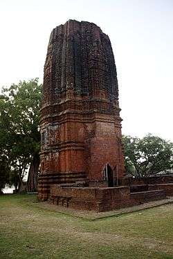
Bahulara, a census village under Onda II village panchayat, is the site of the Siddheshwara temple dedicated to Shiva. It is the finest specimen of brick rekha deul temple ascribed to Pala (medieval) period.[23] It is about 5 km from Ondagram railway station, midway between Bankura and Vishnupur.[24]
At Onda a Dol Mela is held every year for nine days starting on the day of Holi. Datina is a culturally enriched village, situated under Medinipur Gram Panchyat. Here (at Uporpara) a Mela is also held every year for five days starting on Buddha Purnima.
Healthcare
In 2014, Onda CD Block had 1 rural hospital and 5 primary health centres with total 66 beds and 12 doctors. It had 35 family welfare sub centres and 1 family welfare centre. 3,807 patients were treated indoor and 252,239 patients were treated outdoor in the hospitals, health centres and subcentres of the CD Block.[25]
References
- 1 2 O’Malley, L.S.S. "Bengal District Gazetteers: Bankura". Bankura District Authorities. Retrieved 29 August 2016.
- ↑ "District Census Handbook Bankura" (PDF). pages 13-17. Directorate of Census Operations West Bengal. Retrieved 8 December 2016.
- ↑ "District Statistical Handbook 2014 Bankura". Tables 2.1, 2.2,. Department of Statistics and Programme Implementation, Government of West Bengal. Archived from the original on 29 July 2017. Retrieved 10 October 2016.
- ↑ "District Census Handbook: Bankura" (PDF). Map of Bankura with CD Block HQs and Police Stations (on the fifth page). Directorate of Census Operations, West Bengal, 2011. Retrieved 20 November 2016.
- ↑ "Directory of District, Subdivision, Panchayat Samiti/ Block and Gram Panchayats in West Bengal". Bankura - Revised in March 2008. Panchayats and Rural Development Department, Government of West Bengal. Retrieved 27 August 2016.
- 1 2 3 4 "C.D. Block Wise Primary Census Abstract Data(PCA)". 2011 census: West Bengal – District-wise CD Blocks. Registrar General and Census Commissioner, India. Retrieved 29 August 2016.
- ↑ "Provisional population totals, West Bengal, Table 4, Bankura District". Census of India 2001. Census Commission of India. Archived from the original on 28 September 2011. Retrieved 18 August 2016.
- ↑ "Provisional Population Totals, West Bengal. Table 4". Census of India 2001. Census Commission of India. Archived from the original on 27 September 2007. Retrieved 17 July 2016.
- ↑ "Bankura District: Census 2011 data". 2016 Digital Trends. Census Population 2015 Data. Retrieved 20 August 2016.
- 1 2 "Provisional population tables and annexures" (PDF). Census 2011:Table 2(3) Literates and Literacy rates by sex. Registrar General and Census Commissioner, India. Retrieved 20 August 2016.
- 1 2 "C1 Population by Religious Community". West Bengal. Registrar General and Census Commissioner, India. Retrieved 28 August 2016.
- ↑ "ST-14 A Details Of Religions Shown Under 'Other Religions And Persuasions' In Main Table". West Bengal. Registrar General and Census Commissioner, India. Retrieved 28 August 2016.
- ↑ "District Human Development Report: Bankura" (PDF). April 2007. Page 27, Pages 237-244. Development & Planning Department, Government of West Bengal. Retrieved 8 December 2016.
- 1 2 3 4 5 6 7 "District Statistical Handbook 2014 Bankura". Tables 8.2, 17.2, 18.2, 18.1, 20.1, 21.2, 4.4, 3.1, 3.3 – arranged as per use. Department of Statistics and Programme Implementation, Government of West Bengal. Archived from the original on 29 July 2017. Retrieved 6 December 2016.
- ↑ "District Human Development Report: Bankura" (PDF). April 2007. Page: 58. Development & Planning Department, Government of West Bengal. Retrieved 23 August 2016.
- ↑ "District Human Development Report: Bankura" (PDF). April 2007. Page: 85. Development & Planning Department, Government of West Bengal. Retrieved 23 August 2016.
- ↑ "District Human Development Report: Bankura" (PDF). April 2007. Pages: 83-84. Development & Planning Department, Government of West Bengal. Retrieved 23 August 2016.
- ↑ "68089 Midnapore-Adra Memu". Time Table. indiarailinfo. Retrieved 1 September 2016.
- ↑ "Rationalisation of Numbering Systems of National Highways" (PDF). New Delhi: Department of Road Transport and Highways. Retrieved 1 September 2016.
- ↑ "List of State Highways in West Bengal". West Bengal Traffic Police. Retrieved 23 August 2016.
- ↑ "District Statistical Handbook 2014 Bankura". Tables 4.4. Department of Statistics and Programme Implementation, Government of West Bengal. Archived from the original on 29 July 2017. Retrieved 25 August 2016.
- ↑ "Onda Thana Mahavidyalaya". OTM. Retrieved 16 December 2016.
- ↑ "Bahulara". West Bengal. blessingsonthenet.com. Archived from the original on 7 November 2007. Retrieved 17 March 2008.
- ↑ "Bahulara". India9.com. Retrieved 17 March 2008.
- ↑ "District Statistical Handbook 2014 Bankura". Tables 3.1, 3.2, 3.3. Department of Statistics and Programme Implementation, Government of West Bengal. Archived from the original on 29 July 2017. Retrieved 25 August 2016.