Pandua, Hooghly
| Pandua | |
|---|---|
| Town | |
 Pandua Location in West Bengal, India | |
| Coordinates: 23°05′N 88°17′E / 23.08°N 88.28°ECoordinates: 23°05′N 88°17′E / 23.08°N 88.28°E | |
| Country |
|
| State | West Bengal |
| District | Hooghly |
| Elevation | 19 m (62 ft) |
| Population (2011) | |
| • Total | 30,700 |
| Languages | |
| • Official | Bengali, English |
| Time zone | UTC+5:30 (IST) |
| PIN |
712149 vehicle_code_range = |
| Lok Sabha constituency | Hooghly |
| Vidhan Sabha constituency | Pandua |
Pandua (also spelt Pandooah) is a census town in Pandua CD Block in Hooghly district in the Indian state of West Bengal. It is a police station in Chinsurah subdivision.[1] It is 61 kilometres (38 mi) from Howrah station and 21 kilometres (13 mi) from Bandel on the Howrah-Bardhaman Main Line of Eastern Railway and is part of the Kolkata Suburban Railway system.[2]
History
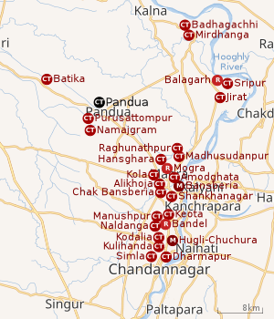 |
| Cities and towns in the Chinsurah subdivision (except Polba Dadpur and Dhaniakhali CD Blocks) in Hooghly district M: municipal city/ town, CT: census town, R: rural/ urban centre, Owing to space constraints in the small map, the actual locations in a larger map may vary slightly |
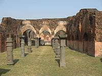
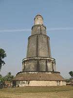
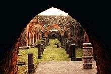
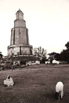
The place is best known for its minar[3] and the ruins of Pandu Raja's Palace where all important state ceremonies were held.[4] The 13th century minar soars to a height of 125 feet.[5]
Shahid Shah Safiuddin was the nephew of Feroz Shah Khilji the Sultan of Delhi. It is said that a Pandu Raja lived in Mahanad in Hooghly where cow slaughter was totally banned. However the Sultan settled in Pandua for the occasion of his son's circumciscion (Khatnah) ceremony. So he had slaughtered a cow for feast to offer to his guests. This enraged the King and he sacrificed the saint's son to Goddess Kali. Shah Safiuddin went to Delhi and complained to the Firoz Shah Khilji about this horrific incident.The Sultan sent a large army under the command of Jaffar Khan Ghazi during {1290-1295 AD}. Taking the spiritual guidance from his guide Shah Bu Ali Qalandar at Panipat, Pandua was attacked. The imperial army was victorious after a long battle. However Shah Safiuddin was fatally wounded. He was buried at the spot where he fell during the battle, with lot of respect and joy. There remains his Dargah near Pandua GT road. A mosque was also built later.
The Shrikkhala Devi Shrine as a Shakti Peeth
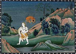
The mythology of Daksha yaga and Sati's self immolation had immense significance in shaping the ancient Sanskrit literature and even had impact on the culture of India. It led to the development of the concept of Shakti Peethas and there by strengthening Shaktism. Enormous mythological stories in puranas took the Daksha yaga as the reason for its origin. It is an important incident in Shaivism resulting in the emergence of Shree Parvati in the place of Sati Devi and making Shiva a grihastashrami (house holder) leading to the origin of Ganapathy and Subrahmanya.[6]
Shakti Peethas are shrines or divine places of the Mother Goddess. These are places that are believes to have enshrined with the presence of Shakti due to the falling of body parts of the corpse of Sati Devi, when Lord Shiva carried it and wandered throughout Aryavartha in sorrow. There are 51 Shakti Peeth linking to the 51 alphabets in Sanskrit.
Geography
Location
Pandua is located at 23°05′N 88°17′E / 23.08°N 88.28°E.[7]It has an average elevation of 19 metres (62 feet).
Pandua, Purusattompur and Namajgram form a cluster of census towns. [7]
Pandua CD Block is a flat alluvial plain, known as the Hooghly-Damodar Plain, that forms part of the Gangetic Delta.[8]
Demographics
As per 2011 Census of India Pandua had a total population of 30,700 of which 15,597 (51%) were males and 15,103 (49%) were females. Population below 6 years was 2,986. The total number of literates in Pandua was 22,604 (81.56% of the population over 6 years).[9]
As of 2001 India census, Pandua had a population of 27,126. Males constitute 51% of the population and females 49%. Pandua has an average literacy rate of 67%, higher than the national average of 59.5%: male literacy is 72%, and female literacy is 62%. In Pandua, 12% of the population is under 6 years of age.[10]
Police station
Pandua police station has jurisdiction over Pandua CD Block.[11][12]
CD Block HQ
The headquarters of Pandua CD Block are located at Pandua.[13]
Economy
This is a rich agricultural area with several cold storages.[14]
S.R.Industry, manufacturer of construction and agricultural machinery was established at Pandua in 1996.[15]
Transport
Visitor attractions
- Bari Masjid: The meaning of the bari is "the big mosque which shows the incredible architecture styled with Bricks". It was built by Shah Sufiuddin in 14th century.
- Pandua Minar: It was built by Shah Sufiuddin in 1340 AD and it is symbol of victory.
Healthcare
Pandua has a rural hospital (with 30 beds).[18]
References
- ↑ District-wise list of statutory towns Archived 2007-09-30 at the Wayback Machine.
- ↑ Eastern Railway time table.
- ↑ Husain, ABM (2012). "Chhota Pandua Minar". In Islam, Sirajul; Jamal, Ahmed A. Banglapedia: National Encyclopedia of Bangladesh (Second ed.). Asiatic Society of Bangladesh.
- ↑ Das, Dipakranjan (2012). "Bari Mosque". In Islam, Sirajul; Jamal, Ahmed A. Banglapedia: National Encyclopedia of Bangladesh (Second ed.). Asiatic Society of Bangladesh.
- ↑ Minars and Minarettes of India
- ↑ "Kottiyoor Devaswam Temple Administration Portal". kottiyoordevaswom.com/. Kottiyoor Devaswam. Retrieved 20 July 2013.
- 1 2 "Census of India 2011, West Bengal: District Census Handbook, Hooghly" (PDF). Map of Pandua CD Block, page 385. Directorate of Census Operations, West Bengal. Retrieved 25 September 2018.
- ↑ "District Census Handbook: Hugli, Series-20, Part XIIA" (PDF). Physiography, Page 17. Directorate of Census Operations, West Bengal, 2011. Retrieved 28 September 2018.
- ↑ "C.D. Block Wise Primary Census Abstract Data(PCA)". 2011 census: West Bengal – District-wise CD Blocks. Registrar General and Census Commissioner, India. Retrieved 10 June 2016.
- ↑ "Census of India 2001: Data from the 2001 Census, including cities, villages and towns (Provisional)". Census Commission of India. Archived from the original on 2004-06-16. Retrieved 10 June 2016.
- ↑ "District Statistical Handbook 2014 Hooghly". Tables 2.1, 2.2,. Department of Statistics and Programme Implementation, Government of West Bengal. Retrieved 3 October 2018.
- ↑ "Hooghly District Police". West Bengal Police. Retrieved 20 June 2017.
- ↑ "District Census Handbook: Hugli, Series-20, Part XIIA" (PDF). Map of Hooghly district with CD Block HQs and Police Stations (on the fifth page). Directorate of Census Operations, West Bengal, 2011. Retrieved 20 June 2017.
- ↑ "List of functioning Cold Storage of West Bengal District wise as on 18.01.07". West Bengal State Marketing Board. Retrieved 2009-01-28.
- ↑ "S.R.Industry". indiamart.com. Retrieved 14 July 2017.
- ↑ "Road - Highway". Public Works Department, Government of West Bengal. Retrieved 24 February 2017.
- ↑ Google maps
- ↑ "Health & Family Welfare Department". Health Statistics. Government of West Bengal. Retrieved 15 July 2017.
External links
- Pandua Image gallery
- Travel article on Pandua by Rangan Datta
- Rangan Datta's Home Page
- Shrinkhala Shaktipith at Pandua
- Penro Mela - Pandua
- Pandua Chhota Minar
| Wikimedia Commons has media related to Pandua (Hooghly). |