Krishnapur, West Bengal
| Krishnapur | |
|---|---|
| Census Town | |
 Krishnapur Location in West Bengal, India  Krishnapur Krishnapur (India) | |
| Coordinates: 22°40′N 88°16′E / 22.67°N 88.26°ECoordinates: 22°40′N 88°16′E / 22.67°N 88.26°E | |
| Country |
|
| State | West Bengal |
| District | Hooghly |
| Population (2011) | |
| • Total | 8,205 |
| Languages | |
| • Official | Bengali, English |
| Time zone | UTC+5:30 (IST) |
| ISO 3166 code | IN-WB |
| Vehicle registration | WB-16 |
| Website |
wb |
Krishnapur is a census town in Chanditala II CD Block in Srirampore subdivision of Hooghly district in the Indian state of West Bengal. It is under Chanditala police station.[1]
Geography
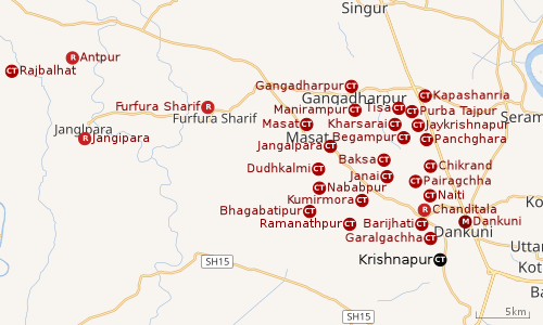 |
| Cities and towns in Chanditala I, Chanditala II and Jangipara CD Blocks in Srirampore subdivision in Hooghly district M: municipal city/ town, CT: census town, R: rural/ urban centre, Owing to space constraints in the small map, the actual locations in a larger map may vary slightly |
Location
Krishnapur is located at 22°40′N 88°16′E / 22.67°N 88.26°E[2]
Kharsarai, Tisa, Kapashanria, Jaykrishnapur, Purba Tajpur, Begampur, Baksa, Panchghara, Chikrand, Janai, Pairagachha, Naiti, Barijhati, Garalgachha and Krishnapur, all the census towns form a series from the northern part of Chanditala II CD Block to its southern part. The only municipality in the area, Dankuni, located outside the CD Block, occupies the south-east corner of the entire cluster.[3]
Urbanisation
Srirampore subdivision is the most urbanized of the subdivisions in Hooghly district. 73.13% of the population in the subdivision is urban and 26.88% is rural. The subdivision has 6 municipalities and 34 census towns. The municipalities are: Uttarpara Kotrung Municipality, Konnagar Municipality, Serampore Municipality, Baidyabati Municipality, Rishra Municipality and Dankuni Municipality. Amongst the CD Blocks in the subdivision, Uttarapara Serampore (census towns shown in a separate map) had 76% urban population, Chanditala I 42%, Chanditala II 69% and Jangipara 7% (census towns shown in the map above).[4][5]All places marked in the map are linked in the larger full screen map.
Demographics
As per 2011 Census of India, Krishnapur had a total population of 8,205 of which 4,115 (50%) were males and 4,090 (50%) were females. Population below 6 years was 809. The total number of literates in Krishnapur was 6,164 (83.34% of the population over 6 years).[5]
As of 2001 India census,[6] Krishnapur had a population of 6,676. Males constitute 50% of the population and females 50%. Krishnapur has an average literacy rate of 69%, higher than the national average of 59.5%: male literacy is 73%, and female literacy is 65%. In Krishnapur, 12% of the population is under 6 years of age.
Transport
The nearest railway station, Dankuni Junction railway station, is 15 kilometres (9.3 mi) from Howrah on the Howrah-Bardhaman chord line and is a part of the Kolkata Suburban Railway system.[7]
Krishnapur is on the State Highway 15.[8]
References
- ↑ "District-wise list of stautory towns". Census Commission of India. Archived from the original on 21 July 2011. Retrieved 2009-01-28.
- ↑ "Krishnapur, India Page". Falling Rain Genomics. Retrieved 2009-02-01.
- ↑ "Census of India 2011, West Bengal: District Census Handbook, Hooghly" (PDF). Map of Chanditala II CD Block, page 663. Directorate of Census Operations, West Bengal. Retrieved 4 October 2018.
- ↑ "District Statistical Handbook 2014 Hooghly". Table 2.2, 2.4(a). Department of Statistics and Programme Implementation, Government of West Bengal. Retrieved 3 October 2018.
- 1 2 "C.D. Block Wise Primary Census Abstract Data(PCA)". 2011 census: West Bengal – District-wise CD Blocks. Registrar General and Census Commissioner, India. Retrieved 3 October 2018.
- ↑ "Census of India 2001: Data from the 2001 Census, including cities, villages and towns (Provisional)". Census Commission of India. Archived from the original on 2004-06-16. Retrieved 2008-11-01.
- ↑ "36811 Howrah Bardhaman Local (via Chord)". indiarailinfo. Retrieved 6 October 2018.
- ↑ Google maps