North Carolina Highway 30
| ||||
|---|---|---|---|---|
 | ||||
| Route information | ||||
| Maintained by NCDOT | ||||
| Length | 15.0 mi[1] (24.1 km) | |||
| Existed | 1970s[2] – present | |||
| Major junctions | ||||
| West end |
| |||
| East end |
| |||
| Location | ||||
| Counties | Pitt | |||
| Highway system | ||||
| ||||

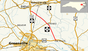
North Carolina Highway 30 (NC 30) is a short primary state highway in the U.S. state of North Carolina entirely in Pitt County.
Route description
NC 30's western terminus is an at-grade intersection with US 13/NC 11 north of Greenville. From there, it heads southeast, and meets up with US 264 east of Greenville. It serves as a bypass of Greenville for travelers going from the north to the east of the city.
History
This road is the third to bear the NC 30 designation. The first was one of North Carolina's original 1922 state highways. As a multiple of "10" it was a major cross-state route, connecting Wilmington to the Virginia state line via Jacksonville, New Bern, Washington, and Ahoskie. In 1930, it was extended to South Carolina via Supply. When the U.S. Highways came in 1934-1935, much of it was replaced by US 17. It was rerouted several times in the late 1930s, but was fully gone by 1940. The remnants of the first NC 30 found in eastern Onslow County continue to serve as a key thoroughfare between Jacksonville and Unincorporated Onslow County, the road is known as "Old 30", "Old Highway 30", and "R.I.P. Road".
The second NC 30 was created in 1948 near where it is today, connecting Greenville to Pactolus. In the mid 1970s, NC 30 and NC 33 swapped places. Today, this route is NC 33 inside of the Greenville Loop and US 264 outside of the loop. When this renumbering occurred, NC 30 was moved to an older alignment of NC 33, which it occupies today.[2]
Junction list
The entire route is in Pitt County.
| Location | mi[1] | km | Destinations | Notes | |
|---|---|---|---|---|---|
| | 0.0 | 0.0 | Western terminus | ||
| Stokes | 7.9 | 12.7 | |||
| Pactolus | 15.0 | 24.1 | Eastern terminus | ||
| 1.000 mi = 1.609 km; 1.000 km = 0.621 mi | |||||
References
Route map:
- 1 2 Google (December 27, 2012). "North Carolina Highway 30" (Map). Google Maps. Google. Retrieved December 27, 2012.
- 1 2 NCRoads Annex - NC 30 Archived August 28, 2006, at the Wayback Machine.