Belvoir, North Carolina
| Belvoir, North Carolina | |
|---|---|
| Census-designated place | |
 Belvoir, North Carolina Location within the state of North Carolina | |
| Coordinates: 35°42′29″N 77°27′53″W / 35.70806°N 77.46472°WCoordinates: 35°42′29″N 77°27′53″W / 35.70806°N 77.46472°W | |
| Country | United States |
| State | North Carolina |
| County | Pitt |
| Area | |
| • Total | 2.0 sq mi (5.1 km2) |
| • Land | 2.0 sq mi (5.1 km2) |
| • Water | 0.0 sq mi (0.0 km2) |
| Population (2010) | |
| • Total | 307 |
| • Density | 160/sq mi (60/km2) |
| Time zone | UTC-5 (Eastern (EST)) |
| • Summer (DST) | UTC-4 (EDT) |
| FIPS code | 37-04955 |
| GNIS feature ID | 1024465 |
Belvoir is a census-designated place within Belvoir Township, Pitt County, North Carolina, United States. As of the 2010 census it had a population of 307.[1]
It is located 6 miles northwest of Greenville along North Carolina Highway 222.
References
- ↑ "Profile of General Population and Housing Characteristics: 2010 Demographic Profile Data (DP-1): Belvoir CDP, North Carolina". U.S. Census Bureau, American Factfinder. Archived from the original on September 11, 2013. Retrieved November 6, 2012.
Municipalities and communities of Pitt County, North Carolina, United States | ||
|---|---|---|
| City | 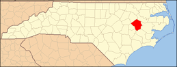 | |
| Towns | ||
| Townships |
| |
| CDPs | ||
| Unincorporated communities | ||
| Footnotes | ‡This populated place also has portions in an adjacent county or counties | |
This article is issued from
Wikipedia.
The text is licensed under Creative Commons - Attribution - Sharealike.
Additional terms may apply for the media files.