Calumet County, Wisconsin
| Calumet County, Wisconsin | |
|---|---|
 | |
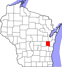 Location in the U.S. state of Wisconsin | |
 Wisconsin's location in the U.S. | |
| Founded | 1850 |
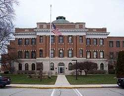
| Seat | Chilton |
| Largest city | Chilton |
| Area | |
| • Total | 397 sq mi (1,028 km2) |
| • Land | 318 sq mi (824 km2) |
| • Water | 79 sq mi (205 km2), 20% |
| Population | |
| • (2010) | 48,971 |
| • Density | 154/sq mi (59/km2) |
| Congressional district | 8th |
| Time zone | Central: UTC−6/−5 |
| Website |
www |
Calumet County is a county located in the U.S. state of Wisconsin. As of the 2010 census, the population was 48,971.[1] The county seat is Chilton.[2] The county was created in 1836 (then in the Wisconsin Territory) and organized in 1850.[3]
Calumet County is included in the Appleton, WI Metropolitan Statistical Area as well as the Appleton-Oshkosh-Neenah, WI Combined Statistical Area.
The Holyland is partially located in southern Calumet County.
History
The county's name originated from the word calumet, the French name for the ceremonial pipes used by Native Americans in councils on the east shore of Lake Winnebago.[4]
In the 1830s, the United States government relocated Native Americans from New York and New England to the southwest part of the county; these included the Brothertown Indians, Oneida Indians, and Stockbridge-Munsee Indians. This was a second migration for the Brothertown and Stockbridge Indians, who had moved to New York after the American Revolutionary War. The Oneida shared land on their reservation with these peoples, who had been displaced by the years of colonization in New England, warfare and disease. Each of the three groups are federally recognized with reservations in Wisconsin.
Many of the early European residents in the Holyland region in the southern part of the county were emigrants from the Schleswig-Holstein region in Germany in the 1840s.
The county was legally organized on February 5, 1850, by Chapter 84 Laws of 1850.[5]
Calumet County figures prominently in the 2015 Netflix television series Making a Murderer, which documents the arrests and trials of Manitowoc County resident Steven Avery, which involves from 2005 the Calumet sheriff's department and district attorney's office of Ken Kratz.[6]
Geography
According to the U.S. Census Bureau, the county has a total area of 397 square miles (1,030 km2), of which 318 square miles (820 km2) is land and 79 square miles (200 km2) (20%) is water.[7] It is the fifth-smallest county in Wisconsin by land area and fourth-smallest by total area. The west boundary is largely in Lake Winnebago. The Niagara Escarpment runs north-south several miles east of the western boundary. The topography has been greatly influenced by glaciation.
Adjacent counties
- Brown County – northeast
- Manitowoc County – east
- Sheboygan County – southeast
- Fond du Lac County – southwest
- Winnebago County – west
- Outagamie County – northwest
Demographics
| Historical population | |||
|---|---|---|---|
| Census | Pop. | %± | |
| 1840 | 275 | — | |
| 1850 | 1,743 | 533.8% | |
| 1860 | 1,895 | 8.7% | |
| 1870 | 12,335 | 550.9% | |
| 1880 | 16,632 | 34.8% | |
| 1890 | 16,639 | 0.0% | |
| 1900 | 17,078 | 2.6% | |
| 1910 | 16,701 | −2.2% | |
| 1920 | 17,228 | 3.2% | |
| 1930 | 16,848 | −2.2% | |
| 1940 | 17,618 | 4.6% | |
| 1950 | 18,840 | 6.9% | |
| 1960 | 22,268 | 18.2% | |
| 1970 | 27,604 | 24.0% | |
| 1980 | 30,867 | 11.8% | |
| 1990 | 34,291 | 11.1% | |
| 2000 | 40,631 | 18.5% | |
| 2010 | 48,971 | 20.5% | |
| Est. 2016 | 49,553 | [8] | 1.2% |
| U.S. Decennial Census[9] 1790–1960[10] 1900–1990[11] 1990–2000[12] 2010–2014[1] | |||
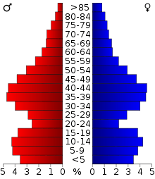

As of the census[13] of 2000, there were 40,631 people, 14,910 households, and 11,167 families residing in the county. The population density was 127 per square mile (49/km2). There were 15,758 housing units at an average density of 49 per square mile (19/km2). The racial makeup of the county was 96.68% White, 0.31% Black or African American, 0.34% Native American, 1.55% Asian, 0.01% Pacific Islander, 0.38% from other races, and 0.74% from two or more races. 1.07% of the population were Hispanic or Latino of any race. 63.4% were of German ancestry according to Census 2000. 96.0% spoke English, 1.7% Spanish and 1.2% German as their first language.
There were 14,910 households out of which 38.50% had children under the age of 18 living with them, 65.00% were married couples living together, 6.50% had a female householder with no husband present, and 25.10% were non-families. 20.40% of all households were made up of individuals and 7.50% had someone living alone who was 65 years of age or older. The average household size was 2.70 and the average family size was 3.15.
In the county, the population was spread out with 28.60% under the age of 18, 7.20% from 18 to 24, 32.00% from 25 to 44, 21.40% from 45 to 64, and 10.80% who were 65 years of age or older. The median age was 35 years. For every 100 females there were 100.00 males. For every 100 females age 18 and over, there were 99.00 males.
Economy
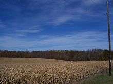
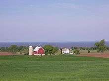
The University of Wisconsin–Extension has compiled statistics on Calumet County's dairy industry. Calumet County has more bovines (cattle and calves) than people. As of 2010 there are 28,600 head of dairy cows and 65,000 head of bovine total (that includes dairy cows, beef cattle, and calves.)[14] 73% of land in the county is owned by farmers. 2400 residents are employed in farming. Agriculture results in $338 million in economic activity, and it contributes $68.2 million in income to the county total income (including $7.2 million towards taxes). As of 2007, 99.3% of farms are owned by individuals, families, family partnerships or family corporations. Only 0.7% are owned by non-family corporate entities.[15] As of April 1, 2010, Calumet county had 174 farms with dairy herd licenses.[16]
In 1931, the Wisconsin Department of Agriculture described Calumet County as "one of the most important producers of American cheese among the counties of Wisconsin."[17]
Transportation
Major highways
No interstate highways run through Calumet County. There are several U.S. routes in the county. U.S. Route 10 runs east-west across the north edge of the county. U.S. Route 151 runs north-south near the west edge of the county, and turns east-west at the middle of the county. North-south state highways include 55 along the west edge, and 32/57 through the center. East-west state highways include 114 at the northwest corner of the county, and the now defunct 149 along the southeast corner. The Tri-County Expressway (WI 441) runs in an east-west to north-south curve in the extreme northwest corner of the county within Appleton city limits.
Airport
New Holstein Municipal Airport (8D1) serves the county and surrounding communities. It is located just west of New Holstein.
Water
Nearly the entire west boundary of the county is located in Lake Winnebago. The first non-natives to enter the county most likely came in the county from the lake through the Fox River. The Manitowoc River and Sheboygan River both run through the county and flow into Lake Michigan through neighboring counties.
Recreation
County Parks
Calumet County has three county parks, and two county run harbors.
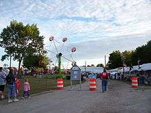
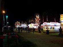
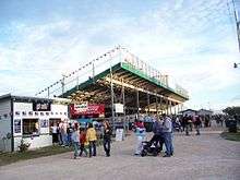
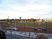
Calumet County Fairgrounds
Calumet County celebrated its 150th annual fair in 2006.[18] The fairgrounds held dirt track stockcars races on Friday nights in the summer.
Lake Winnebago
The west boundary of the county is located almost entirely in Lake Winnebago. Boaters use the lake for recreational boating and fishing in the summer. The lake is the site of ice fishing in the winter, and the Wisconsin Department of Natural Resources manages a sturgeon spearing season in February.
Communities
Cities
- Appleton (mostly in Outagamie County and Winnebago County)
- Brillion
- Chilton (county seat)
- Kaukauna, Wisconsin (mostly in Outagamie County, Wisconsin)
- Kiel (mostly in Manitowoc County)
- Menasha (mostly in Winnebago County)
- New Holstein
Villages
- Harrison (partial)
- Hilbert
- Potter
- Sherwood
- Stockbridge
Towns
Census-designated place
Unincorporated communities
- Brant
- Brothertown
- Calumetville (partial)
- Charlesburg
- Dorns Faro Springs Beach
- Dorns Twilight Beach
- Dundas
- Eckers Lakeland
- Hayton
- Highland Beach
- Jericho
- Kloten
- Maple Heights
- Meggers (partial)
- Quinney
- Rockaway Beach
- St. Anna (partial)
- St. John
- Utowana Beach
- Waverly Beach (partial)
- Wells (partial)
Ghost town/neighborhood
Politics
| Year | Republican | Democratic | Third parties |
|---|---|---|---|
| 2016 | 57.8% 15,367 | 36.3% 9,642 | 6.0% 1,586 |
| 2012 | 55.0% 14,539 | 43.5% 11,489 | 1.5% 392 |
| 2008 | 48.1% 12,722 | 50.2% 13,295 | 1.7% 457 |
| 2004 | 58.2% 14,721 | 40.7% 10,290 | 1.1% 265 |
| 2000 | 54.3% 10,837 | 41.1% 8,202 | 4.6% 908 |
| 1996 | 43.3% 7,049 | 42.6% 6,940 | 14.2% 2,310 |
| 1992 | 41.0% 7,541 | 31.0% 5,701 | 28.0% 5,159 |
| 1988 | 55.1% 8,107 | 44.1% 6,481 | 0.8% 120 |
| 1984 | 64.6% 8,970 | 34.1% 4,736 | 1.3% 186 |
| 1980 | 55.2% 7,885 | 35.2% 5,036 | 9.6% 1,372 |
| 1976 | 50.2% 6,589 | 47.5% 6,241 | 2.3% 302 |
| 1972 | 55.9% 6,446 | 41.6% 4,804 | 2.5% 292 |
| 1968 | 56.8% 5,792 | 35.4% 3,609 | 7.9% 802 |
| 1964 | 42.1% 3,905 | 57.8% 5,356 | 0.1% 13 |
| 1960 | 54.5% 5,166 | 45.5% 4,312 | 0.1% 8 |
| 1956 | 74.2% 6,166 | 25.3% 2,099 | 0.5% 43 |
| 1952 | 77.1% 6,640 | 22.9% 1,970 | 0.1% 5 |
| 1948 | 60.6% 4,185 | 38.5% 2,662 | 0.9% 62 |
| 1944 | 73.6% 5,611 | 25.8% 1,966 | 0.6% 49 |
| 1940 | 69.0% 5,327 | 30.1% 2,324 | 1.0% 74 |
| 1936 | 27.7% 1,972 | 66.0% 4,694 | 6.3% 447 |
| 1932 | 17.9% 1,213 | 80.8% 5,485 | 1.3% 87 |
| 1928 | 38.0% 2,405 | 61.2% 3,871 | 0.7% 47 |
| 1924 | 18.6% 938 | 11.3% 569 | 70.1% 3,539 |
| 1920 | 78.3% 3,730 | 12.3% 586 | 9.4% 450 |
| 1916 | 57.2% 1,979 | 39.9% 1,382 | 2.9% 100 |
| 1912 | 32.6% 931 | 47.8% 1,366 | 19.7% 563 |
| 1908 | 46.3% 1,576 | 50.3% 1,711 | 3.4% 115 |
| 1904 | 55.0% 1,736 | 39.8% 1,258 | 5.2% 164 |
| 1900 | 45.1% 1,631 | 52.8% 1,910 | 2.1% 75 |
| 1896 | 44.5% 1,547 | 53.8% 1,869 | 1.7% 58 |
| 1892 | 31.6% 909 | 64.7% 1,863 | 3.8% 109 |
See also
References
- 1 2 "State & County QuickFacts". United States Census Bureau. Retrieved January 18, 2014.
- ↑ "Find a County". National Association of Counties. Archived from the original on 2011-05-31. Retrieved 2011-06-07.
- ↑ "Wisconsin: Individual County Chronologies". Wisconsin Atlas of Historical County Boundaries. The Newberry Library. 2007. Retrieved August 13, 2015.
- ↑ Stories compiled and presented by the New Holstein Historical Society. Pioneer's Corner. pp. 69–70.
|access-date=requires|url=(help) - ↑ Wulff, Eugene C. The New Holstein Story.
|access-date=requires|url=(help) - ↑ "Making a Murderer (TV Series)". IMDb. Retrieved 2015-12-28.
- ↑ "2010 Census Gazetteer Files". United States Census Bureau. August 22, 2012. Retrieved August 2, 2015.
- ↑ "Population and Housing Unit Estimates". Retrieved June 9, 2017.
- ↑ "U.S. Decennial Census". United States Census Bureau. Archived from the original on May 12, 2015. Retrieved August 2, 2015.
- ↑ "Historical Census Browser". University of Virginia Library. Retrieved August 2, 2015.
- ↑ Forstall, Richard L., ed. (March 27, 1995). "Population of Counties by Decennial Census: 1900 to 1990". United States Census Bureau. Retrieved August 2, 2015.
- ↑ "Census 2000 PHC-T-4. Ranking Tables for Counties: 1990 and 2000" (PDF). United States Census Bureau. April 2, 2001. Retrieved August 2, 2015.
- ↑ "American FactFinder". United States Census Bureau. Archived from the original on 2013-09-11. Retrieved 2011-05-14.
- ↑ http://www.nass.usda.gov/Statistics_by_State/Wisconsin/index.asp#.html Archived 2010-06-12 at the Wayback Machine.
- ↑ "Calumet County Agriculture: Value and economic impact" (PDF). University of Wisconsin–Extension. Retrieved 2010-05-17.
- ↑ Wisconsin Farm Reporter, Wisconsin Field Office of the National Agricultural Statistics Service; May 25, 2010; Volume 10, Number 11
- ↑ November 23, 2006 article "Looking Back" Chilton Times-Journal, Page 7.
- ↑ Mike Mathes "Homestead, Avery case top '06 news"; January 4, 2007; Page 2; Tri-County News
- ↑ Leip, David. "Dave Leip's Atlas of U.S. Presidential Elections". uselectionatlas.org. Retrieved 2018-05-07.
External links
- Calumet County Government
- Calumet County map from the Wisconsin Department of Transportation
- Calumet County Fair
Places adjacent to Calumet County, Wisconsin | ||||||||||
|---|---|---|---|---|---|---|---|---|---|---|
| ||||||||||
| Core cities |  | |
|---|---|---|
| Largest municipalities over 10,000 in 2010 | ||
| Municipalities under 10,000 in 2010 |
| |
| Counties | ||
| ||
Municipalities and communities of Calumet County, Wisconsin, United States | ||
|---|---|---|
| Cities | | |
| Villages | ||
| Towns | ||
| CDP | ||
| Unincorporated communities | ||
| Ghost town/neighborhood | ||
| Footnotes | ‡This populated place also has portions in an adjacent county or counties | |
