Cudahy, Wisconsin
| Cudahy, Wisconsin | |
|---|---|
| City | |
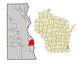 Location of Cudahy in Milwaukee County, Wisconsin. | |
| Coordinates: 42°56′54″N 87°51′40″W / 42.94833°N 87.86111°WCoordinates: 42°56′54″N 87°51′40″W / 42.94833°N 87.86111°W | |
| Country | United States |
| State | Wisconsin |
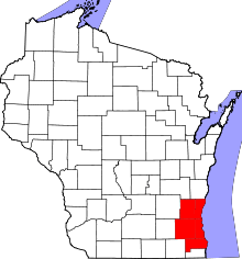
| County | Milwaukee |
| Government | |
| • Mayor | John R. Hohenfeldt |
| Area[1] | |
| • Total | 4.76 sq mi (12.33 km2) |
| • Land | 4.76 sq mi (12.33 km2) |
| • Water | 0 sq mi (0 km2) |
| Elevation[2] | 722 ft (220 m) |
| Population (2010)[3] | |
| • Total | 18,267 |
| • Estimate (2016)[4] | 18,200 |
| • Density | 3,837.6/sq mi (1,481.7/km2) |
| Time zone | UTC-6 (Central (CST)) |
| • Summer (DST) | UTC-5 (CDT) |
| Area code(s) | 414 |
| FIPS code | 55-17975[5] |
| GNIS feature ID | 1563607[2] |
| Website |
www |
Cudahy is a city in Milwaukee County, Wisconsin, United States, North America. The population was 18,267 at the 2010 census.
History
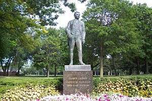
Originally known as the Buckhorn Settlement, it was renamed in the late 1800s when Patrick Cudahy[6] purchased 700 acres (280 ha) of land in the Town of Lake, two miles (three kilometers) from the Milwaukee city limits, to build his meatpacking plant. The first village president was elected in 1895, and by 1906 Cudahy was incorporated as a city with a population of 2,556.[7]
Geography
Cudahy is located at 42°56′54″N 87°51′40″W / 42.94833°N 87.86111°W (42.948416, -87.861010).[8] According to the United States Census Bureau, the city has a total area of 4.76 square miles (12.3 km2), all of it land.[1]
Demographics
| Historical population | |||
|---|---|---|---|
| Census | Pop. | %± | |
| 1900 | 1,366 | — | |
| 1910 | 3,691 | 170.2% | |
| 1920 | 6,725 | 82.2% | |
| 1930 | 10,631 | 58.1% | |
| 1940 | 10,561 | −0.7% | |
| 1950 | 12,182 | 15.3% | |
| 1960 | 17,975 | 47.6% | |
| 1970 | 22,078 | 22.8% | |
| 1980 | 19,547 | −11.5% | |
| 1990 | 18,659 | −4.5% | |
| 2000 | 18,429 | −1.2% | |
| 2010 | 18,267 | −0.9% | |
| Est. 2016 | 18,200 | [4] | −0.4% |
| U.S. Decennial Census[9] | |||
2010 census
As of the census[3] of 2010, there were 18,267 people, 8,059 households, and 4,666 families residing in the city. The population density was 3,837.6 inhabitants per square mile (1,481.7/km2). There were 8,662 housing units at an average density of 1,819.7 per square mile (702.6/km2). The racial makeup of the city was 88.8% White, 2.7% African American, 0.9% Native American, 1.4% Asian, 3.6% from other races, and 2.7% from two or more races. Hispanic or Latino of any race were 9.7% of the population.
Out of 8,059 households, 27.0% had children under the age of 18 living with them, 40.7% were married couples living together, 11.8% had a female householder with no husband present, 5.4% had a male householder with no wife present, and 42.1% were non-families. 35.5% of all households were made up of individuals, and 13.1% had someone living alone who was 65 years of age or older. The average household size was 2.26 and the average family size was 2.94.
The median age in the city was 40.3 years. 21.5% of residents were under the age of 18; 7.8% were between the ages of 18 and 24; 26.6% were from 25 to 44; 28.3% were from 45 to 64; and 15.7% were 65 years of age or older. The gender makeup of the city was 49.1% male and 50.9% female.
2000 census
As of the census[5] of 2000, there were 18,429 people, 7,888 households, and 4,890 families residing in the city. The population density was 3,880.1 people per square mile (1,498.0/km²). There were 8,273 housing units at an average density of 1,741.8 per square mile (672.5/km²). The racial makeup of the city was 93.89% White, 0.95% African American, 0.81% Native American, 0.84% Asian, 0.03% Pacific Islander, 1.45% from other races, and 2.03% from two or more races. Hispanic or Latino of any race were 4.73% of the population.
Out of 7,888 households, 28.0% had children under the age of 18 living with them, 46.6% were married couples living together, 11.6% had a female householder with no husband present, and 37.9% were non-families. 32.5% of all households were made up of individuals and 12.8% had someone living alone who was 65 years of age or older. The average household size was 2.32 and the average family size was 2.94.
In the city, the population was spread out with 23.0% under the age of 18, 8.0% from 18 to 24, 31.3% from 25 to 44, 21.9% from 45 to 64, and 15.8% who were 65 years of age or older. The median age was 38 years. For every 100 females, there were 95.6 males. For every 100 females age 18 and over, there were 92.9 males.
The median income for a household in the city was US$40,157, and the median income for a family was $49,082. Males had a median income of $36,787 versus $25,882 for females. The per capita income for the city was $19,615. About 5.6% of families and 8.2% of the population were below the poverty line, including 11.1% of those under age 18 and 6.3% of those age 65 or over.
Education
The Cudahy School District provides public education for the area. Cudahy High School is the local high school.
St. Paul's Lutheran School is a K4-8 Christian grade school of the Wisconsin Evangelical Lutheran Synod in Cudahy.[10]
Government
Cudahy is represented by Gwen Moore (D) in the United States House of Representatives, and by Ron Johnson (R) and Tammy Baldwin (D) in the United States Senate. Chris Larson (D) represents Cudahy in the Wisconsin State Senate, and Christine Sinicki (D) represents Cudahy in the Wisconsin State Assembly.
Notable people
- Albert M. Bielawski, Michigan State Representative
- Frank Chermak, Wisconsin legislator
- Patrick Cudahy, Founder of Cudahy and Cudahy Packing Company
- Barney Augustus Eaton, Wisconsin legislator
- Lamar Gordon, NFL Running Back
- Lawrence P. Kelly, mayor of Cudahy and legislator
- Frank Kosikowski, professional football player
- Jim Miklaszewski, NBC News correspondent for the Pentagon
- Vaughn Monroe, Big Band era singer, lived in Cudahy for a time as a child.[11]
- John Navarre, NFL quarterback
- Sherman R. Sobocinski, Wisconsin legislator
References
- 1 2 "US Gazetteer files 2010". United States Census Bureau. Archived from the original on 2012-01-24. Retrieved 2012-11-18.
- 1 2 "US Board on Geographic Names". United States Geological Survey. 2007-10-25. Retrieved 2008-01-31.
- 1 2 "American FactFinder". United States Census Bureau. Retrieved 2012-11-18.
- 1 2 "Population and Housing Unit Estimates". Retrieved June 9, 2017.
- 1 2 "American FactFinder". United States Census Bureau. Archived from the original on 2013-09-11. Retrieved 2008-01-31.
- ↑ Company, Chicago and North Western Railway (1908). A History of the Origin of the Place Names Connected with the Chicago & North Western and Chicago, St. Paul, Minneapolis & Omaha Railways. p. 61.
- ↑ http://www.cudahyhistoricalsociety.org
- ↑ "US Gazetteer files: 2010, 2000, and 1990". United States Census Bureau. 2011-02-12. Retrieved 2011-04-23.
- ↑ "Census of Population and Housing". Census.gov. Archived from the original on May 12, 2015. Retrieved June 4, 2015.
- ↑ "St. Paul's Lutheran School".
- ↑ http://www.vaughnmonroesociety.org/biography.htmRetrieved+2017-02-12.
External links
Municipalities and communities of Milwaukee County, Wisconsin, United States | ||
|---|---|---|
| Cities | 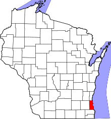 | |
| Villages | ||
| Ghost towns/ neighborhoods | ||
| Indian reservation | ||
| Footnotes | ‡This populated place also has portions in another county or counties | |