St. Croix County, Wisconsin
| Saint Croix County, Wisconsin | |
|---|---|
 | |
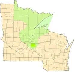
 Location in the U.S. state of Wisconsin | |
 Wisconsin's location in the U.S. | |
| Founded | 1849 |
| Seat | Hudson |
| Largest city | Hudson |
| Area | |
| • Total | 736 sq mi (1,906 km2) |
| • Land | 722 sq mi (1,870 km2) |
| • Water | 13 sq mi (34 km2), 1.8% |
| Population | |
| • (2010) | 84,345 |
| • Density | 117/sq mi (45/km2) |
| Congressional district | 7th |
| Time zone | Central: UTC−6/−5 |
| Website |
co |
St. Croix County is a county in the U.S. state of Wisconsin. As of the 2010 census, the population was 84,345.[1] Its county seat is Hudson.[2] The county was created in 1840 (then in the Wisconsin Territory) and organized in 1849.[3]
St. Croix County is part of the Minneapolis-St. Paul-Bloomington, MN-WI Metropolitan Statistical Area. Between 2000 and 2010, it was the fastest-growing county in Wisconsin.[4]
History
St. Croix County was created on August 3, 1840[5] by the legislature of the Wisconsin Territory. It was named after the river on its western border.[6] Sources vary on the origin of the name; the St. Croix River may have been named after Monsieur St. Croix, an explorer who drowned at the mouth of the river late in the seventeenth century. Another account credits Father Hennepin with giving this region the French name Ste Croix (Holy Cross) because of the burial markers located at the mouth of the river.[7]
La Pointe County (now extinct, see Bayfield County) was created from the northern portions of Wisconsin Territory's St. Croix County on February 19, 1845.[8] When Wisconsin was admitted into the union as a state on May 29, 1848, the territorial St. Croix County was further divided, with the territory from the Mississippi River to the current border of Minnesota continuing as de facto Wisconsin Territory until on March 3, 1849,[9][10][11] it and unorganized federal territory lying north of Iowa were used in the creation of the Minnesota Territory.[12] Itasca, Washington, Ramsey and Benton Counties were created by the Minnesota Territory on October 27, 1849[13] from the de facto Wisconsin Territory that had been separated from the Wisconsin Territory's La Pointe County.
The part of St. Croix County allocated to Wisconsin became the parental county to Pierce and Polk Counties, and formed significant portions of Dunn, Barron, Washburn and Burnett Counties.
On June 12, 1899, a deadly F5 tornado struck New Richmond. The tornado's damage path was 400 yards (370 m) wide and 46 miles (74 km) long. The tornado formed on the banks of the St. Croix River, south of Hudson. Moving to the northeast across St. Croix County, the tornado passed through the villages of Burkhardt and Boardman before striking New Richmond head on leveling the entire business district and half the town's residences. The storm continued on towards the northeast, narrowly missing the town of Deer Park before crossing into Polk County, where it again narrowly missed the towns of Clear Lake, Richardson and Clayton. Once the tornado passed into Barron County, it struck the village of Arland (No reported fatalities or serious injuries) before breaking up southwest of Barron. The tornado killed 117 people (Four at Boardman, two in Polk County and the rest at New Richmond), including at least 20 people who died from their injuries in the days after the storm. Largely in thanks to state aid and donations, most of the town was rebuilt by the following winter. Today, the tornado stands as the deadliest ever recorded in Wisconsin and the 9th deadliest tornado in U.S. history.
Geography
According to the U.S. Census Bureau, the county has a total area of 736 square miles (1,910 km2), of which 722 square miles (1,870 km2) is land and 13 square miles (34 km2) (1.8%) is water.[14]
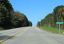
Major highways
Airport
New Richmond Regional Airport (KRNH) serves the county and surrounding communities.
National protected area
Adjacent counties
- Polk County - north
- Barron County - northeast
- Dunn County - east
- Pierce County - south
- Washington County, Minnesota - west
Demographics
| Historical population | |||
|---|---|---|---|
| Census | Pop. | %± | |
| 1840 | 809 | — | |
| 1850 | 624 | −22.9% | |
| 1860 | 5,392 | 764.1% | |
| 1870 | 11,035 | 104.7% | |
| 1880 | 18,956 | 71.8% | |
| 1890 | 23,139 | 22.1% | |
| 1900 | 26,830 | 16.0% | |
| 1910 | 25,910 | −3.4% | |
| 1920 | 26,106 | 0.8% | |
| 1930 | 25,455 | −2.5% | |
| 1940 | 24,842 | −2.4% | |
| 1950 | 25,905 | 4.3% | |
| 1960 | 29,164 | 12.6% | |
| 1970 | 34,354 | 17.8% | |
| 1980 | 43,262 | 25.9% | |
| 1990 | 50,251 | 16.2% | |
| 2000 | 63,155 | 25.7% | |
| 2010 | 84,345 | 33.6% | |
| Est. 2016 | 88,029 | [15] | 4.4% |
| U.S. Decennial Census[16] 1790–1960[17] 1900–1990[18] 1990–2000[19] 2010–2014[1] | |||
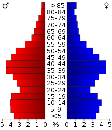
As of the census[20] of 2000, there were 63,155 people, 23,410 households, and 16,948 families residing in the county. The population density was 88 people per square mile (34/km²). There were 24,265 housing units at an average density of 34 per square mile (13/km²). The racial makeup of the county was 97.85% White, 0.28% Black or African American, 0.25% Native American, 0.62% Asian, 0.02% Pacific Islander, 0.22% from other races, and 0.76% from two or more races. 0.76% of the population were Hispanic or Latino of any race. 34.4% were of German, 19.3% Norwegian, 8.2% Irish and 5.4% Swedish ancestry.
There were 23,410 households out of which 38.00% had children under the age of 18 living with them, 61.60% were married couples living together, 7.00% had a female householder with no husband present, and 27.60% were non-families. 21.20% of all households were made up of individuals and 7.30% had someone living alone who was 65 years of age or older. The average household size was 2.66 and the average family size was 3.12.
In the county, the population was spread out with 27.90% under the age of 18, 8.20% from 18 to 24, 32.20% from 25 to 44, 21.90% from 45 to 64, and 9.90% who were 65 years of age or older. The median age was 35 years. For every 100 females there were 100.20 males. For every 100 females age 18 and over, there were 98.50 males.
Communities
Cities
- Glenwood City
- Hudson (county seat)
- New Richmond
- River Falls (mostly in Pierce County)
Villages
Towns
Census-designated places
Unincorporated communities
Politics
| Year | Republican | Democratic | Third parties |
|---|---|---|---|
| 2016 | 55.2% 26,222 | 36.8% 17,482 | 8.0% 3,804 |
| 2012 | 55.2% 25,503 | 43.1% 19,910 | 1.8% 812 |
| 2008 | 51.0% 22,837 | 47.3% 21,177 | 1.8% 807 |
| 2004 | 54.2% 22,679 | 44.9% 18,784 | 0.9% 372 |
| 2000 | 50.9% 15,240 | 43.7% 13,077 | 5.5% 1,637 |
| 1996 | 35.6% 8,253 | 49.0% 11,384 | 15.4% 3,576 |
| 1992 | 31.6% 8,114 | 40.0% 10,281 | 28.4% 7,281 |
| 1988 | 46.3% 9,960 | 52.9% 11,392 | 0.8% 181 |
| 1984 | 52.5% 11,367 | 46.8% 10,127 | 0.7% 141 |
| 1980 | 42.6% 9,265 | 46.9% 10,203 | 10.6% 2,299 |
| 1976 | 41.2% 7,685 | 56.8% 10,601 | 2.1% 386 |
| 1972 | 52.5% 8,553 | 46.0% 7,488 | 1.5% 250 |
| 1968 | 46.6% 6,595 | 48.1% 6,807 | 5.3% 746 |
| 1964 | 33.9% 4,565 | 65.9% 8,864 | 0.2% 29 |
| 1960 | 52.8% 7,113 | 47.1% 6,341 | 0.2% 24 |
| 1956 | 55.7% 6,956 | 44.1% 5,499 | 0.2% 29 |
| 1952 | 59.8% 7,607 | 40.0% 5,094 | 0.2% 25 |
| 1948 | 40.4% 4,326 | 57.7% 6,173 | 1.9% 202 |
| 1944 | 53.0% 5,660 | 46.2% 4,930 | 0.8% 88 |
| 1940 | 57.7% 6,857 | 41.2% 4,898 | 1.0% 121 |
| 1936 | 38.5% 4,316 | 41.7% 4,679 | 19.8% 2,223 |
| 1932 | 37.9% 4,059 | 59.6% 6,374 | 2.5% 265 |
| 1928 | 62.2% 6,855 | 37.0% 4,083 | 0.8% 88 |
| 1924 | 39.7% 3,600 | 7.9% 718 | 52.4% 4,755 |
| 1920 | 73.3% 5,601 | 21.5% 1,638 | 5.2% 398 |
| 1916 | 51.1% 2,731 | 44.0% 2,352 | 4.9% 262 |
| 1912 | 37.2% 1,728 | 38.9% 1,806 | 24.0% 1,114 |
| 1908 | 62.3% 3,228 | 34.2% 1,773 | 3.5% 181 |
| 1904 | 68.3% 3,898 | 27.5% 1,569 | 4.2% 238 |
| 1900 | 59.0% 3,368 | 36.4% 2,076 | 4.7% 266 |
| 1896 | 56.4% 3,462 | 40.3% 2,475 | 3.3% 203 |
| 1892 | 47.0% 2,467 | 42.3% 2,220 | 10.6% 557 |
See also
References
- 1 2 "State & County QuickFacts". United States Census Bureau. Retrieved January 23, 2014.
- ↑ "Find a County". National Association of Counties. Retrieved 2011-06-07.
- ↑ "Wisconsin: Individual County Chronologies". Wisconsin Atlas of Historical County Boundaries. The Newberry Library. 2007. Retrieved August 15, 2015.
- ↑ "Urban areas siphon Wisconsin's rural residents - USATODAY.com". USATODAY.COM. Retrieved 2018-08-14.
- ↑ Laws of the Territory of Wisconsin. Belmont and Milwaukee, 1836–1848. no. 20, sec. 1/pp. 25-6
- ↑ "Winnebago Took Its Name from an Indian Tribe". The Post-Crescent. December 28, 1963. p. 14. Retrieved August 25, 2014 – via Newspapers.com.

- ↑ "Archived copy" (PDF). Archived from the original (PDF) on 2011-07-26. Retrieved 2008-08-19. History of St. Croix County
- ↑ Laws of the Territory of Wisconsin. Belmont and Milwaukee, 1836–1848. 1845 pp. 52-3
- ↑ Statutes at Large of the United States of America, 1789–1873. 17 vols. Boston: Little, Brown, 1845–1874. vol. 9, ch. 89 [1846]/pp. 56-58
- ↑ Statutes at Large of the United States of America, 1789–1873. 17 vols. Boston: Little, Brown, 1845–1874. vol. 9, ch. 50 [1848]/pp. 233-235
- ↑ Van Zandt, Franklin K. Boundaries of the United States and the Several States. Geological Survey Professional Paper 909. Washington, D.C.: Government Printing Office, 1976. pp. 128-130
- ↑ Statutes at Large of the United States of America, 1789–1873. 17 vols. Boston: Little, Brown, 1845–1874.vol. 9, ch. 121 [1849]/pp. 403-9
- ↑ Session Laws of the Territory of Minnesota. St. Paul, 1850-1857. [1849] ch. 5, secs. 2-5, 7-9, 19-20/pp. 7-9
- ↑ "2010 Census Gazetteer Files". United States Census Bureau. August 22, 2012. Retrieved August 9, 2015.
- ↑ "Population and Housing Unit Estimates". Retrieved June 9, 2017.
- ↑ "U.S. Decennial Census". United States Census Bureau. Retrieved August 9, 2015.
- ↑ "Historical Census Browser". University of Virginia Library. Retrieved August 9, 2015.
- ↑ Forstall, Richard L., ed. (March 27, 1995). "Population of Counties by Decennial Census: 1900 to 1990". United States Census Bureau. Retrieved August 9, 2015.
- ↑ "Census 2000 PHC-T-4. Ranking Tables for Counties: 1990 and 2000" (PDF). United States Census Bureau. April 2, 2001. Retrieved August 9, 2015.
- ↑ "American FactFinder". United States Census Bureau. Retrieved 2011-05-14.
- ↑ Leip, David. "Dave Leip's Atlas of U.S. Presidential Elections". uselectionatlas.org. Retrieved 2018-08-14.
Further reading
- Johnson, Helen Sophia. Early History of St. Croix County, Wisconsin. Madison: University of Wisconsin, 1921.
External links
- St. Croix County government website
- St. Croix County map at the Wisconsin Department of Transportation
Places adjacent to St. Croix County, Wisconsin | ||||||||||
|---|---|---|---|---|---|---|---|---|---|---|
| ||||||||||
Municipalities and communities of St. Croix County, Wisconsin, United States | ||
|---|---|---|
| Cities | | |
| Villages | ||
| Towns | ||
| CDPs | ||
| Unincorporated communities | ||
| Footnotes | ‡This populated place also has portions in an adjacent county or counties | |
