Rock River (Mississippi River tributary)
| Rock River | |
|---|---|
 | |
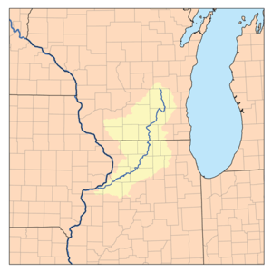 Drainage basin of the Rock River | |
| Physical characteristics | |
| Main source |
Horicon Marsh north of Horicon, Wisconsin 43°28′26″N 88°38′41″W / 43.4738889°N 88.6447222°W |
| River mouth |
Confluence with the Mississippi River at Rock Island, Illinois 551 ft (168 m) 41°28′57″N 90°36′58″W / 41.4825326°N 90.6162489°WCoordinates: 41°28′57″N 90°36′58″W / 41.4825326°N 90.6162489°W |
| Length | 299 mi (481 km) |
| Basin features | |
| Progression | Rock River → Mississippi → Gulf of Mexico |
| GNIS ID | 416824 |
The Rock River is a tributary of the Mississippi River, approximately 299 miles (481 km) long,[1][2] in the U.S. states of Wisconsin and Illinois. The river was known as the Sinnissippi to Sauk and Fox Indians; the name means "rocky waters".[3]
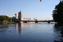
The river begins with three separate branches which flow into the Horicon Marsh.[4] The northernmost branch, the West Branch, begins just to the west of the village of Brandon in Fond du Lac County, Wisconsin and flows east and then south to Horicon Marsh. The South Branch rises north of Fox Lake in Dodge County and flows east through Waupun to the marsh. The East Branch rises southeast of Allenton in Washington County just west of the Niagara Escarpment, and flows north and west through Theresa to the marsh. Leaving the marsh, it meanders southward to the Illinois border ending about 300 miles later at the Mississippi River at the Quad Cities in Illinois and Iowa.[5] During its course it passes through Watertown, collects the Crawfish River in Jefferson, and receives the Bark River at Fort Atkinson. In northern Rock County it receives the Yahara River, and flows southward through Janesville and Beloit into northern Illinois, where it receives the Pecatonica River 5 miles (8 km) south of the state line.
It flows south through Rockford, then southwest across northwestern Illinois, picking up the Kishwaukee River, passing Oregon, Dixon, Sterling and Rock Falls before joining the Mississippi at Rock Island. It was on the Rock River in Dixon where Ronald Reagan was a lifeguard.[6] Reagan's favorite fishing spot, now called "Dutch Landing" after Reagan's nickname, was just southwest of Lowell Park on the Rock River.
Shortly before merging, the Rock and Crawfish rivers cross Interstate 94. Both rivers flood the nearby land regularly, and lanes on I-94 were temporarily closed in 2008 because of this flooding.[7]
There are 23 dams on the Rock River.[8] These are in Theresa (WI, 3 dams), Waupun (WI), Horicon (WI), Hustisford (WI), Watertown (WI, 2 dams), Jefferson (WI, 4 dams), Indianford (WI), Janesville (WI, 2 dams), Beloit (WI), Rockton (IL), Rockford Fordham (IL), Oregon (IL), Dixon (IL), Sterling / Rock Falls (IL, 2 dams), Milan (IL) and Rock Island (IL).[9]
The river is used for various water and paddling sports. The Rock River Water Trail is on the river from its headwaters above the Horicon National Wildlife Refuge in south central Wisconsin to the confluence with the Mississippi River at the Quad Cities of Illinois and Iowa 330 miles downriver. It crosses five counties in Wisconsin, six counties in Illinois and runs through 37 municipalities. The slow moving river passes scenic rural landscapes, wilderness areas and urban areas. The first two trailheads are at Waupun County Park in Waupun, Wisconsin and Rivers Edge Park in Theresa, Wisconsin and there are 32 additional access points in Dodge County, Wisconsin. The trail is part of the National Water Trails System and the first National Water Trail in Wisconsin and Illinois.[10]
Rock River Park is on County Road B about a half mile west of Johnson Creek, Wisconsin in Jefferson County, Wisconsin and offers river access and an artesian spring.[11]
Cities and villages along the river

Communities listed from north to south.
- Brandon, Wisconsin (West Branch)
- Waupun, Wisconsin (South Branch)
- Theresa, Wisconsin (East Branch)
- Mayville, Wisconsin (East Branch)
- Horicon, Wisconsin
- Hustisford, Wisconsin
- Watertown, Wisconsin
- Johnson Creek, Wisconsin
- Jefferson, Wisconsin
- Fort Atkinson, Wisconsin
- Indianford, Wisconsin
- Fulton, Wisconsin
- Janesville, Wisconsin
- Afton, Wisconsin
- Beloit, Wisconsin
- South Beloit, Illinois
- Rockton, Illinois
- Roscoe, Illinois
- Machesney Park, Illinois
- Loves Park, Illinois
- Rockford, Illinois
- Byron, Illinois
- Oregon, Illinois
- Grand Detour, Illinois
- Dixon, Illinois
- Sterling, Illinois
- Rock Falls, Illinois
- Lyndon, Illinois
- Prophetstown, Illinois
- Erie, Illinois
- Hillsdale, Illinois
- Cleveland, Illinois
- Colona, Illinois
- Moline, Illinois
- Coal Valley, Illinois
- Milan, Illinois
- Rock Island, Illinois
See also
| Wikimedia Commons has media related to Rock River (Illinois-Wisconsin). |
References
- ↑ U.S. Geological Survey. National Hydrography Dataset high-resolution flowline data. The National Map, accessed May 13, 2011
- ↑ U.S. Geological Survey Geographic Names Information System: Rock River
- ↑ "Castle Rock State Park". Illinois DNR. Archived from the original on 2007-04-01. Retrieved 2014-08-03.
- ↑ http://dnr.wi.gov/water/basin/uprock
- ↑ "Upper Rock River Basin - WDNR". Dnr.wi.gov. Retrieved 2016-02-03.
- ↑ City of Dixon. "Reagan's Roots".
- ↑ Channel 3000. "Interstate 94, Highway 151 Reopen As Water Recedes". Channel 3000. Archived from the original on 17 November 2009. Retrieved 3 February 2016.
- ↑ "Dam Information". Rock River Trail. Retrieved 22 April 2014.
- ↑ "Rock River Dams". PaddleAway. Retrieved 22 April 2014.
- ↑ "Dodge County, Wisconsin : Rock River Water Trail". Retrieved 3 February 2016.
- ↑ "Welcome to Jefferson County, Wisconsin". Retrieved 3 February 2016.