Burnett County, Wisconsin
| Burnett County, Wisconsin | |
|---|---|
 | |
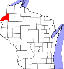 Location in the U.S. state of Wisconsin | |
 Wisconsin's location in the U.S. | |
| Founded | 1865 |
| Seat | Siren[1] |
| Largest village | Grantsburg |
| Area | |
| • Total | 880 sq mi (2,279 km2) |
| • Land | 822 sq mi (2,129 km2) |
| • Water | 58 sq mi (150 km2), 6.6% |
| Population | |
| • (2010) | 15,457 |
| • Density | 19/sq mi (7/km2) |
| Congressional district | 7th |
| Time zone | Central: UTC−6/−5 |
| Website |
burnettcounty |
Burnett County is a county located in the U.S. state of Wisconsin. As of the 2010 census, the population was 15,457.[2] Its county seat is Siren,[1][3] with the majority of county governmental services located at the Burnett County Government Center. The county was created in 1856 and organized in 1865.[4]
Geography
According to the U.S. Census Bureau, the county has a total area of 880 square miles (2,300 km2), of which 872 square miles (2,260 km2) is land and 58 square miles (150 km2) (6.6%) is water.[6] Saginaw Lake is located in the county,[7] south of the Namekagon River.
Adjacent counties
- Douglas County – northeast
- Washburn County – east
- Barron County – southeast
- Polk County – south
- Chisago County, Minnesota – southwest
- Pine County, Minnesota – west
Major highways
Airports
- Burnett County Airport (KRZN) serves the county and surrounding communities.
- Grantsburg Municipal Airport (KGTG) enhances county service.
National protected area
Demographics
| Historical population | |||
|---|---|---|---|
| Census | Pop. | %± | |
| 1860 | 12 | — | |
| 1870 | 706 | 5,783.3% | |
| 1880 | 3,140 | 344.8% | |
| 1890 | 4,393 | 39.9% | |
| 1900 | 7,478 | 70.2% | |
| 1910 | 9,026 | 20.7% | |
| 1920 | 10,735 | 18.9% | |
| 1930 | 10,233 | −4.7% | |
| 1940 | 11,382 | 11.2% | |
| 1950 | 10,236 | −10.1% | |
| 1960 | 9,214 | −10.0% | |
| 1970 | 9,276 | 0.7% | |
| 1980 | 12,340 | 33.0% | |
| 1990 | 13,084 | 6.0% | |
| 2000 | 15,674 | 19.8% | |
| 2010 | 15,457 | −1.4% | |
| Est. 2016 | 15,213 | [8] | −1.6% |
| U.S. Decennial Census[9] 1790–1960[10] 1900–1990[11] 1990–2000[12] 2010–2014[2] | |||
As of the census[13] of 2000, there were 15,674 people, 6,613 households, and 4,503 families residing in the county. The population density was 19 people per square mile (7/km²). There were 12,582 housing units at an average density of 15 per square mile (6/km²). The racial makeup of the county was 93.25% White, 0.36% Black or African American, 4.45% Native American, 0.24% Asian, 0.07% Pacific Islander, 0.21% from other races, and 1.42% from two or more races. 0.77% of the population were Hispanic or Latino of any race. 28.9% were of German, 15.4% Swedish, 12.8% Norwegian and 6.3% Irish ancestry.
There were 6,613 households out of which 25.10% had children under the age of 18 living with them, 56.20% were married couples living together, 7.50% had a female householder with no husband present, and 31.90% were non-families. 26.90% of all households were made up of individuals and 12.20% had someone living alone who was 65 years of age or older. The average household size was 2.33 and the average family size was 2.80.
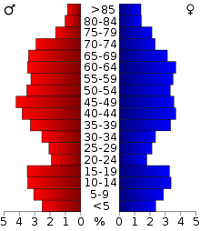
In the county, the population was spread out with 22.10% under the age of 18, 6.00% from 18 to 24, 23.20% from 25 to 44, 28.40% from 45 to 64, and 20.30% who were 65 years of age or older. The median age was 44 years. For every 100 females there were 101.50 males. For every 100 females age 18 and over, there were 100.30 males.
Communities
Burnett County is one of only three Wisconsin counties that have no incorporated cities. It is the only Wisconsin county to have villages but no cities.
Villages
Towns
Census-designated place
Unincorporated communities
Politics
| Year | Republican | Democratic | Third parties |
|---|---|---|---|
| 2016 | 61.9% 5,410 | 33.8% 2,949 | 4.3% 379 |
| 2012 | 52.4% 4,550 | 45.9% 3,986 | 1.6% 141 |
| 2008 | 48.3% 4,200 | 49.9% 4,337 | 1.7% 151 |
| 2004 | 50.9% 4,743 | 48.3% 4,499 | 0.9% 79 |
| 2000 | 48.7% 3,967 | 44.5% 3,626 | 6.8% 558 |
| 1996 | 34.2% 2,452 | 50.6% 3,625 | 15.2% 1,092 |
| 1992 | 31.5% 2,340 | 42.7% 3,172 | 25.9% 1,924 |
| 1988 | 44.6% 2,884 | 54.7% 3,537 | 0.7% 44 |
| 1984 | 51.0% 3,528 | 48.2% 3,331 | 0.8% 57 |
| 1980 | 44.8% 3,027 | 47.4% 3,200 | 7.8% 528 |
| 1976 | 39.9% 2,573 | 57.7% 3,720 | 2.3% 150 |
| 1972 | 54.4% 2,972 | 43.7% 2,389 | 1.9% 105 |
| 1968 | 45.8% 2,056 | 44.8% 2,010 | 9.4% 422 |
| 1964 | 34.4% 1,536 | 65.5% 2,921 | 0.1% 6 |
| 1960 | 54.0% 2,483 | 45.6% 2,095 | 0.4% 18 |
| 1956 | 52.4% 2,198 | 47.3% 1,986 | 0.3% 14 |
| 1952 | 60.4% 2,683 | 39.2% 1,741 | 0.4% 16 |
| 1948 | 40.8% 1,590 | 55.8% 2,177 | 3.4% 132 |
| 1944 | 52.7% 2,119 | 46.5% 1,868 | 0.8% 32 |
| 1940 | 49.2% 2,510 | 49.2% 2,513 | 1.6% 82 |
| 1936 | 31.9% 1,422 | 62.8% 2,801 | 5.3% 237 |
| 1932 | 33.4% 1,281 | 63.6% 2,437 | 3.0% 115 |
| 1928 | 74.7% 2,742 | 24.0% 880 | 1.3% 48 |
| 1924 | 30.3% 958 | 2.4% 76 | 67.3% 2,124 |
| 1920 | 79.6% 2,025 | 7.4% 187 | 13.1% 333 |
| 1916 | 54.0% 1,007 | 34.2% 638 | 11.8% 221 |
| 1912 | 26.7% 403 | 20.2% 305 | 53.0% 799 |
| 1908 | 72.2% 1,181 | 18.1% 296 | 9.7% 159 |
| 1904 | 86.5% 1,262 | 5.6% 82 | 7.9% 115 |
| 1900 | 80.2% 1,112 | 15.7% 218 | 4.0% 56 |
| 1896 | 67.5% 800 | 29.5% 349 | 3.0% 36 |
| 1892 | 56.7% 406 | 7.7% 55 | 35.6% 255 |
See also
References
- 1 2 Burnett County Clerk. Burnett County Directory June 2016
- 1 2 "State & County QuickFacts". United States Census Bureau. Retrieved January 17, 2014.
- ↑ "The Counties [of Wisconsin]". Wisconsin Counties Association. Retrieved 2018-04-22.
- ↑ "Wisconsin: Individual County Chronologies". Wisconsin Atlas of Historical County Boundaries. The Newberry Library. 2007. Retrieved August 12, 2015.
- ↑ Nelson, Steven (2011). Savanna Soils of Minnesota. Minnesota: Self. pp. 61 - 64. ISBN 978-0-615-50320-2.
- ↑ "2010 Census Gazetteer Files". United States Census Bureau. August 22, 2012. Retrieved August 2, 2015.
- ↑ http://dnr.wi.gov/lakes/lakepages/LakeDetail.aspx?wbic=2494700 Wisconsin DNR: Saginaw Lake
- ↑ "Population and Housing Unit Estimates". Retrieved June 9, 2017.
- ↑ "U.S. Decennial Census". United States Census Bureau. Archived from the original on May 12, 2015. Retrieved August 2, 2015.
- ↑ "Historical Census Browser". University of Virginia Library. Retrieved August 2, 2015.
- ↑ Forstall, Richard L., ed. (March 27, 1995). "Population of Counties by Decennial Census: 1900 to 1990". United States Census Bureau. Retrieved August 2, 2015.
- ↑ "Census 2000 PHC-T-4. Ranking Tables for Counties: 1990 and 2000" (PDF). United States Census Bureau. April 2, 2001. Retrieved August 2, 2015.
- ↑ "American FactFinder". United States Census Bureau. Archived from the original on 2013-09-11. Retrieved 2011-05-14.
- ↑ Leip, David. "Dave Leip's Atlas of U.S. Presidential Elections". uselectionatlas.org. Retrieved 12 April 2018.
Further reading
- Peet, Ed. L. Burnett County, Wisconsin: A Pamphlet Descriptive of Northern Wisconsin in General and of Burnett County in Detail. Grantsburg, Wis.: Burnett County Board of Immigration, 1902.
External links
- Burnett County government website
- Burnett County map from the Wisconsin Department of Transportation
- Brief History of Burnett County
- Fort Folle Avoine Historical Park
Places adjacent to Burnett County, Wisconsin | ||||||||||
|---|---|---|---|---|---|---|---|---|---|---|
| ||||||||||
Municipalities and communities of Burnett County, Wisconsin, United States | ||
|---|---|---|
| Villages | | |
| Towns | ||
| CDP | ||
| Unincorporated communities | ||
| Indian reservations | ||
| Footnotes | ‡This populated place also has portions in an adjacent county or counties | |
