Eau Claire County, Wisconsin
| Eau Claire County, Wisconsin | |
|---|---|
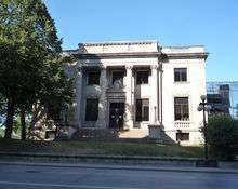
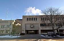 Eau Claire County Courthouse, February 2015 | |
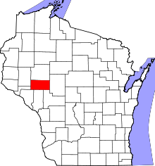 Location in the U.S. state of Wisconsin | |
 Wisconsin's location in the U.S. | |
| Founded | 1856[1] |
| Government • County Administrator |
Kathryn Schauf |
| Seat | Eau Claire |
| Largest city | Eau Claire |
| Area | |
| • Total | 645 sq mi (1,671 km2) |
| • Land | 638 sq mi (1,652 km2) |
| • Water | 7.3 sq mi (19 km2), 1.1% |
| Population (est.) | |
| • (2014) | 101,564 |
| • Density | 159/sq mi (61/km2) |
| Congressional district | 3rd |
| Time zone | Central: UTC−6/−5 |
| Website |
www |
Eau Claire County is a county located in the U.S. state of Wisconsin. As of the 2010 census, the population was 98,736.[2] Its county seat is Eau Claire.[3] The county took its name from the Eau Claire River.[4]
Eau Claire County is included in the Eau Claire, WI Metropolitan Statistical Area as well as the Eau Claire-Menomonie WI Combined Statistical Area.
History
Eau Claire county was originally set off as the Town of Clearwater in Chippewa County in 1855. The name was changed to the Town of Eau Claire on March 31, 1856. The entire town was separated as Eau Claire County by an act of the Wisconsin State Legislature on October 6, 1856.[5][6]
Geography
According to the U.S. Census Bureau, the county has a total area of 645 square miles (1,670 km2), of which 638 square miles (1,650 km2) is land and 7.3 square miles (19 km2) (1.1%) is water.[7]
Adjacent counties
- Chippewa County - north
- Clark County - east
- Jackson County - southeast
- Trempealeau County - south
- Buffalo County - southwest
- Pepin County - west
- Dunn County - west
Demographics
| Historical population | |||
|---|---|---|---|
| Census | Pop. | %± | |
| 1860 | 3,162 | — | |
| 1870 | 10,769 | 240.6% | |
| 1880 | 19,993 | 85.7% | |
| 1890 | 30,673 | 53.4% | |
| 1900 | 31,692 | 3.3% | |
| 1910 | 32,721 | 3.2% | |
| 1920 | 35,771 | 9.3% | |
| 1930 | 41,087 | 14.9% | |
| 1940 | 46,999 | 14.4% | |
| 1950 | 54,187 | 15.3% | |
| 1960 | 58,300 | 7.6% | |
| 1970 | 67,219 | 15.3% | |
| 1980 | 78,805 | 17.2% | |
| 1990 | 85,183 | 8.1% | |
| 2000 | 93,142 | 9.3% | |
| 2010 | 98,736 | 6.0% | |
| Est. 2016 | 102,965 | [8] | 4.3% |
| U.S. Decennial Census[9] 1790–1960[10] 1900–1990[11] 1990–2000[12] 2010–2014[2] | |||
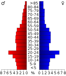
As of the census[13] of 2000, there were 93,142 people, 35,822 households, and 22,281 families residing in the county. The population density was 146 inhabitants per square mile (56/km2). There were 37,474 housing units at an average density of 59 per square mile (23/km²). The racial makeup of the county was 94.96% White, 0.52% Black or African American, 0.54% Native American, 2.52% Asian, 0.03% Pacific Islander, 0.33% from other races, and 1.11% from two or more races. 0.94% of the population were Hispanic or Latino of any race. 37.4% were of German, 21.5% Norwegian and 7.0% Irish ancestry according to Census 2000. 94.2% spoke English, 1.6% Hmong, 1.6% Spanish and 1.0% German as their first language.
There were 35,822 households out of which 30.00% had children under the age of 18 living with them, 50.60% were married couples living together, 8.60% had a female householder with no husband present, and 37.80% were non-families. 27.10% of all households were made up of individuals and 10.10% had someone living alone who was 65 years of age or older. The average household size was 2.46 and the average family size was 3.02.
In the county, the population was spread out with 23.40% under the age of 18, 17.10% from 18 to 24, 26.70% from 25 to 44, 20.50% from 45 to 64, and 12.20% who were 65 years of age or older. The median age was 32 years. For every 100 females, there were 93.80 males. For every 100 females age 18 and over, there were 90.60 males.
Transportation
Major highways
Airport
Eau Claire county is served by the Chippewa Valley Regional Airport (KEAU).
Government
The legislative body of Eau Claire County is the non-partisan 29-member Eau Claire County Board of Supervisors.[14] Members of the board of supervisors are elected by district and the chairperson and vice-chair positions are elected from within members of the board.
The board meets in the Eau Claire County Courthouse in downtown Eau Claire,[15] with its weekly meetings televised on local public television and transcripts published online. Most items are approved on a "consent calendar" without discussion.[16] Public comment is limited to three minutes per individual per item.
Eau Claire County contains portions of the Wisconsin State Senate districts 23 and 31, represented by Terry Moulton (R) and Kathleen Vinehout (D) respectively. It also contains portions of Wisconsin State Assembly districts 68 (Kathy Bernier [R]) and 93 (Warren Petryk [R]), as well as almost all of district 91 (Dana Wachs [D]). At the federal level, the entire county is contained within Wisconsin's third congressional district, which is represented in the United States House of Representatives by Ron Kind (D).
| Year | Republican | Democratic | Third parties |
|---|---|---|---|
| 2016 | 42.4% 23,331 | 49.7% 27,340 | 7.9% 4,354 |
| 2012 | 42.4% 23,256 | 56.0% 30,666 | 1.6% 884 |
| 2008 | 38.1% 20,959 | 60.3% 33,146 | 1.7% 905 |
| 2004 | 44.5% 24,653 | 54.2% 30,068 | 1.3% 716 |
| 2000 | 43.7% 20,921 | 50.3% 24,078 | 6.0% 2,876 |
| 1996 | 34.4% 13,900 | 50.3% 20,298 | 15.3% 6,192 |
| 1992 | 33.8% 15,915 | 45.1% 21,221 | 21.1% 9,940 |
| 1988 | 45.3% 17,664 | 54.2% 21,150 | 0.5% 209 |
| 1984 | 51.1% 20,401 | 48.5% 19,347 | 0.5% 181 |
| 1980 | 44.5% 17,304 | 45.2% 17,602 | 10.3% 4,016 |
| 1976 | 46.4% 16,388 | 51.7% 18,263 | 2.0% 702 |
| 1972 | 51.3% 15,883 | 46.2% 14,300 | 2.5% 760 |
| 1968 | 46.7% 11,799 | 48.7% 12,302 | 4.7% 1,186 |
| 1964 | 35.5% 8,700 | 64.3% 15,775 | 0.2% 46 |
| 1960 | 56.1% 14,427 | 43.7% 11,240 | 0.1% 37 |
| 1956 | 58.5% 13,122 | 41.3% 9,276 | 0.2% 41 |
| 1952 | 59.5% 14,069 | 40.4% 9,554 | 0.2% 35 |
| 1948 | 43.4% 7,825 | 55.3% 9,971 | 1.4% 246 |
| 1944 | 51.1% 9,470 | 48.4% 8,962 | 0.5% 88 |
| 1940 | 48.4% 9,595 | 51.1% 10,129 | 0.5% 108 |
| 1936 | 39.4% 6,802 | 58.3% 10,065 | 2.3% 393 |
| 1932 | 48.8% 7,487 | 49.3% 7,565 | 1.9% 291 |
| 1928 | 69.3% 10,079 | 30.1% 4,385 | 0.6% 91 |
| 1924 | 46.5% 5,149 | 5.7% 629 | 47.9% 5,305 |
| 1920 | 81.6% 7,856 | 12.4% 1,193 | 6.0% 576 |
| 1916 | 53.0% 2,922 | 41.5% 2,290 | 5.5% 301 |
| 1912 | 40.3% 2,013 | 34.6% 1,727 | 25.1% 1,256 |
| 1908 | 64.5% 3,981 | 30.1% 1,859 | 5.4% 332 |
| 1904 | 73.1% 4,343 | 20.6% 1,224 | 6.3% 376 |
| 1900 | 66.4% 4,378 | 29.9% 1,967 | 3.7% 244 |
| 1896 | 63.4% 4,522 | 33.2% 2,364 | 3.4% 244 |
| 1892 | 47.8% 2,719 | 41.9% 2,383 | 10.3% 586 |
Recreation
Attractions include the Chippewa Valley Museum in Eau Claire, Dells Mill Museum in Augusta, Dells Mill Water Powered Museum in Augusta, the Paul Bunyan Logging Camp in Eau Claire, and the Sarge Boyd Bandshell in Eau Claire.[18]
Communities
Cities
- Altoona
- Augusta
- Eau Claire (county seat; partly in Chippewa County)
Villages
Towns
Census-designated places
Unincorporated communities
Ghost towns/neighborhoods
- Hadleyville‡
- Nelsonville‡
- Oak Grove‡
- Porter's Mills‡
- Shawtown§
- Footnotes
‡ Historical community
§ Now part of the City of Eau Claire
See also
References
- ↑ Taken from Wisconsin Blue Book 1991-1992 p. 731; cited there as from "Wisconsin Historical Records, Origin and Legislative History of County Boundariesio in Wisconsin, 1942."
- 1 2 "State & County QuickFacts". United States Census Bureau. Archived from the original on July 9, 2011. Retrieved January 18, 2014.
- ↑ "Find a County". National Association of Counties. Archived from the original on 2012-07-12. Retrieved 2011-06-07.
- ↑ Chicago and North Western Railway Company (1908). A History of the Origin of the Place Names Connected with the Chicago & North Western and Chicago, St. Paul, Minneapolis & Omaha Railways. p. 160.
- ↑ "Dictionary of Wisconsin History". Retrieved 1 January 2007.
- ↑ When Counties Originated from rootsweb.com's Oconto County, Wisconsin webpage Archived 2007-03-29 at the Wayback Machine..
- ↑ "2010 Census Gazetteer Files". United States Census Bureau. August 22, 2012. Retrieved August 4, 2015.
- ↑ "Population and Housing Unit Estimates". Retrieved June 9, 2017.
- ↑ "U.S. Decennial Census". United States Census Bureau. Archived from the original on May 12, 2015. Retrieved August 4, 2015.
- ↑ "Historical Census Browser". University of Virginia Library. Retrieved August 4, 2015.
- ↑ Forstall, Richard L., ed. (March 27, 1995). "Population of Counties by Decennial Census: 1900 to 1990". United States Census Bureau. Retrieved August 4, 2015.
- ↑ "Census 2000 PHC-T-4. Ranking Tables for Counties: 1990 and 2000" (PDF). United States Census Bureau. April 2, 2001. Retrieved August 4, 2015.
- ↑ "American FactFinder". United States Census Bureau. Archived from the original on 2013-09-11. Retrieved 2011-05-14.
- ↑ http://www.naco.org/Template.cfm?Section=Find_a_County&Template=/cffiles/counties/county.cfm&id=55035 Archived 2009-11-03 at the Wayback Machine.
- ↑ "Archived copy" (PDF). Archived from the original (PDF) on 2012-03-02. Retrieved 2012-09-29.
- ↑ "Eau Claire County – County Board of Supervisors". Co.eau-claire.wi.us. Archived from the original on 2011-11-12. Retrieved 2011-11-02.
- ↑ Leip, David. "Dave Leip's Atlas of U.S. Presidential Elections". uselectionatlas.org. Retrieved 2018-05-07.
- ↑ http://www.wisconline.com/cgi-bin/find_attractions.pl?typ=cou&county=Eau%20Claire
Further reading
- Bailey, William F. (ed.). History of Eau Claire County, Wisconsin, Past and Present. Chicago: C. F. Cooper, 1914.
External links
| Wikimedia Commons has media related to Eau Claire County, Wisconsin. |
- Official website
- Eau Claire County map from the Wisconsin Department of Transportation
- History of Eau Claire County
- University of Wisconsin-Eau Claire, Special Collections and Archives
- Chippewa Valley Museum
Places adjacent to Eau Claire County, Wisconsin | ||||||||||
|---|---|---|---|---|---|---|---|---|---|---|
| ||||||||||
| Core cities |  | ||||
|---|---|---|---|---|---|
| Surrounding communities |
| ||||
| Counties | |||||
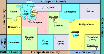
Municipalities and communities of Eau Claire County, Wisconsin, United States | ||
|---|---|---|
| Cities | | |
| Villages | ||
| Towns | ||
| CDP | ||
| Unincorporated communities | ||
| Ghost towns/neighborhoods | ||
| Indian reservation | ||
| Footnotes | ‡This populated place also has portions in an adjacent county or counties | |
