Vilas County, Wisconsin
| Vilas County, Wisconsin | |
|---|---|
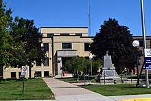 Vilas County Courthouse | |
 Location in the U.S. state of Wisconsin | |
 Wisconsin's location in the U.S. | |
| Founded | April 12, 1893 |
| Named for | William Freeman Vilas |
| Seat | Eagle River |
| Largest city | Eagle River |
| Area | |
| • Total | 1,018 sq mi (2,637 km2) |
| • Land | 857 sq mi (2,220 km2) |
| • Water | 161 sq mi (417 km2), 16% |
| Population | |
| • (2010) | 21,430 |
| • Density | 25/sq mi (10/km2) |
| Congressional district | 7th |
| Time zone | Central: UTC−6/−5 |
| Website |
www |
Vilas County is a county in the state of Wisconsin, United States. As of the 2010 census, the population was 21,430.[1] Its county seat is Eagle River.[2]
History
Settlement
The earliest inhabitants of Vilas County were members of the Chippewa band of Native Americans; the first recorded white settler was a man named Ashman who established a trading post in Lac du Flambeau in 1818.[3]
In the 1850s migrants from New England, primarily from Vermont and Connecticut, constructed wagon roads and trails through Vilas County including the Ontonogan Mail Trail and a military road from Fort Howard to Fort Wilkins in Copper Harbor, Michigan.[3]
Vilas County was set off from Oneida County on April 12, 1893 and named for William Freeman Vilas. Originally from Vermont, Vilas represented Wisconsin in the United States Senate from 1891 to 1897.[4][5]
Logging era
Logging began in the late 1850s. Loggers came from Cortland County, New York, Carroll County, New Hampshire, Orange County, Vermont and Down East Maine in what is now Washington County, Maine and Hancock County, Maine.[6] Many dams were built throughout the county to assist loggers as they sent their timber downstream to the lumber and paper mills in the Wisconsin River valley.[3] After the county was founded in 1893 and logging ceased to be the primary industry in the area, migrants seeking other forms of employment settled in the county. These later immigrants primarily came from Germany, Ireland and Poland though some came from other parts of the United States as well.[6]
Geography
According to the U.S. Census Bureau, the county has a total area of 1,018 square miles (2,640 km2), of which 857 square miles (2,220 km2) is land and 161 square miles (420 km2) (16%) is water.[7] There are 1,318 lakes in the county. Much of Vilas County is covered by the Chequamegon-Nicolet National Forest and the Northern Highland-American Legion State Forest as well as extensive county forest lands. Vilas County waters drain to Lake Superior, Lake Michigan, and the Mississippi River. The Wisconsin, Flambeau, and Presque Isle Rivers all find their headwaters in Vilas County.
Adjacent counties
- Forest County - southeast
- Iron County - west
- Oneida County - south
- Price County - southwest
- Gogebic County, Michigan - north
- Iron County, Michigan - northeast
Major highways
Airports
- KARV - Lakeland Airport / Noble F. Lee Memorial Field
- KEGV - Eagle River Union Airport
- KLNL - Kings Land O' Lakes Airport
- D25 - Manitowish Waters Airport
National protected areas
- Chequamegon National Forest (part)
- Nicolet National Forest (part)
Although these two forests have been administratively combined into the Chequamegon-Nicolet National Forest, it is important to note that the county contains portions of both original forests.
Demographics
| Historical population | |||
|---|---|---|---|
| Census | Pop. | %± | |
| 1900 | 4,929 | — | |
| 1910 | 6,019 | 22.1% | |
| 1920 | 5,649 | −6.1% | |
| 1930 | 7,294 | 29.1% | |
| 1940 | 8,894 | 21.9% | |
| 1950 | 9,363 | 5.3% | |
| 1960 | 9,332 | −0.3% | |
| 1970 | 10,958 | 17.4% | |
| 1980 | 16,535 | 50.9% | |
| 1990 | 17,707 | 7.1% | |
| 2000 | 21,033 | 18.8% | |
| 2010 | 21,430 | 1.9% | |
| Est. 2016 | 21,435 | [8] | 0.0% |
| U.S. Decennial Census[9] 1790–1960[10] 1900–1990[11] 1990–2000[12] 2010–2014[1] | |||
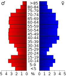
As of the census[13] of 2000, there were 21,033 people, 9,066 households, and 6,300 families residing in the county. The population density was 24 people per square mile (9/km²). There were 22,397 housing units at an average density of 26 per square mile (10/km²). The racial makeup of the county was 89.69% White, 0.20% Black or African American, 9.08% Native American, 0.18% Asian, 0.01% Pacific Islander, 0.19% from other races, and 0.65% from two or more races. 0.86% of the population were Hispanic or Latino of any race. 37.8% were of German, 7.9% Polish, 6.6% Irish and 5.3% English ancestry according to Census 2000. 95.9% spoke English, 1.3% Spanish and 1.2% German as their first language.
There were 9,066 households out of which 23.40% had children under the age of 18 living with them, 58.40% were married couples living together, 7.50% had a female householder with no husband present, and 30.50% were non-families. 26.00% of all households were made up of individuals and 12.60% had someone living alone who was 65 years of age or older. The average household size was 2.29 and the average family size was 2.73.
In the county, the population was spread out with 20.70% under the age of 18, 5.00% from 18 to 24, 23.10% from 25 to 44, 28.50% from 45 to 64, and 22.80% who were 65 years of age or older. The median age was 46 years. For every 100 females there were 99.10 males. For every 100 females age 18 and over, there were 95.80 males.
Economy
The economy in Vilas County is based on tourism centered on its high concentration of lakes and forests. Hunting and sport fishing are the backbones of the fall economy, and ice fishing and especially snowmobiling makes up the bulk of the economy in the wintertime. Logging, forestry, construction and government also account for important parts of the local economy.
Communities
Cities
- Eagle River (county seat)
Towns
Census-designated places
Other unincorporated communities
Notable people
- Screenwriter Winifred Dunn was born in Vilas County.
Politics
| Year | Republican | Democratic | Third parties |
|---|---|---|---|
| 2016 | 60.0% 8,166 | 35.1% 4,770 | 5.0% 675 |
| 2012 | 56.0% 7,749 | 43.0% 5,951 | 1.0% 142 |
| 2008 | 51.3% 7,055 | 47.2% 6,491 | 1.5% 204 |
| 2004 | 58.2% 8,155 | 40.8% 5,713 | 1.0% 134 |
| 2000 | 56.5% 6,958 | 38.2% 4,706 | 5.3% 658 |
| 1996 | 43.0% 4,496 | 40.5% 4,226 | 16.5% 1,723 |
| 1992 | 41.0% 4,616 | 33.4% 3,764 | 25.6% 2,882 |
| 1988 | 60.1% 5,842 | 38.9% 3,781 | 1.0% 99 |
| 1984 | 66.1% 5,965 | 32.6% 2,940 | 1.3% 121 |
| 1980 | 60.8% 6,034 | 33.2% 3,293 | 6.0% 597 |
| 1976 | 59.3% 4,929 | 38.6% 3,209 | 2.1% 174 |
| 1972 | 65.9% 4,422 | 28.4% 1,907 | 5.7% 379 |
| 1968 | 58.1% 3,339 | 31.3% 1,798 | 10.6% 608 |
| 1964 | 49.8% 2,827 | 50.0% 2,841 | 0.2% 11 |
| 1960 | 64.3% 3,508 | 35.6% 1,942 | 0.2% 10 |
| 1956 | 74.1% 3,683 | 25.5% 1,267 | 0.4% 22 |
| 1952 | 70.9% 3,687 | 28.8% 1,497 | 0.4% 20 |
| 1948 | 58.3% 2,665 | 36.9% 1,688 | 4.8% 218 |
| 1944 | 48.9% 2,021 | 50.3% 2,079 | 0.8% 32 |
| 1940 | 46.9% 2,251 | 51.5% 2,470 | 1.6% 77 |
| 1936 | 31.3% 1,298 | 61.7% 2,559 | 7.0% 288 |
| 1932 | 34.3% 1,138 | 61.3% 2,036 | 4.4% 145 |
| 1928 | 58.5% 1,609 | 39.3% 1,083 | 2.2% 61 |
| 1924 | 42.1% 873 | 5.7% 119 | 52.1% 1,081 |
| 1920 | 66.1% 903 | 18.7% 255 | 15.3% 209 |
| 1916 | 48.5% 531 | 42.6% 467 | 8.9% 98 |
| 1912 | 32.9% 304 | 35.4% 327 | 31.6% 292 |
| 1908 | 71.7% 794 | 25.1% 278 | 3.2% 35 |
| 1904 | 79.1% 1,467 | 17.4% 322 | 3.6% 66 |
| 1900 | 69.3% 1,208 | 28.0% 488 | 2.8% 48 |
| 1896 | 62.0% 754 | 36.4% 443 | 1.6% 19 |
Images
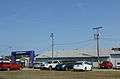 Cars parked by the entrance to the Vilas County Fairgrounds during the 2015 fair
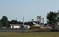 Rides during the 2015 county fair
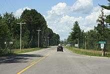
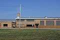 The Vilas County Highway Department near Eagle River
See also
References
- 1 2 "State & County QuickFacts". United States Census Bureau. Retrieved January 24, 2014.
- ↑ "Find a County". National Association of Counties. Archived from the original on May 31, 2011. Retrieved 2011-06-07.
- 1 2 3 Vilas County, WI Government Main Page Accessed January 11, 2011
- ↑ William Freeman Vilas: Doctrinaire Democrat Front Cover Horace Samuel Merrill State Historical Society of Wisconsin, 1954
- ↑ Vilas County History.
- 1 2 History of Northern Wisconsin Illustrated. Chicago: Western Historical Company, 1881.
- ↑ "2010 Census Gazetteer Files". United States Census Bureau. August 22, 2012. Retrieved August 9, 2015.
- ↑ "Population and Housing Unit Estimates". Retrieved June 9, 2017.
- ↑ "U.S. Decennial Census". United States Census Bureau. Archived from the original on May 12, 2015. Retrieved August 9, 2015.
- ↑ "Historical Census Browser". University of Virginia Library. Retrieved August 9, 2015.
- ↑ Forstall, Richard L., ed. (March 27, 1995). "Population of Counties by Decennial Census: 1900 to 1990". United States Census Bureau. Retrieved August 9, 2015.
- ↑ "Census 2000 PHC-T-4. Ranking Tables for Counties: 1990 and 2000" (PDF). United States Census Bureau. April 2, 2001. Retrieved August 9, 2015.
- ↑ "American FactFinder". United States Census Bureau. Archived from the original on September 11, 2013. Retrieved 2011-05-14.
- ↑ Leip, David. "Dave Leip's Atlas of U.S. Presidential Elections". uselectionatlas.org. Retrieved 12 April 2018.
Further reading
- Commemorative Biographical Record of the Upper Wisconsin Counties of Waupaca, Portage, Wood, Marathon, Lincoln, Oneida, Vilas, Langlade and Shawano. Chicago: J. H. Beers, 1895.
- Jones, George O.; McVean, Norman S. (comp.). History of Lincoln, Oneida and Vilas Counties, Wisconsin. Minneapolis: H. C. Cooper, Jr., 1924.
External links
- Vilas County government website
- Vilas County Chamber of Commerce
- Vilas County map from the Wisconsin Department of Transportation
Places adjacent to Vilas County, Wisconsin | ||||||||||
|---|---|---|---|---|---|---|---|---|---|---|
| ||||||||||
Municipalities and communities of Vilas County, Wisconsin, United States | ||
|---|---|---|
| City | | |
| Towns | ||
| CDPs | ||
| Unincorporated communities | ||
| Indian reservations | ||
| Footnotes | ‡This populated place also has portions in an adjacent county or counties | |
