Muskego, Wisconsin
| Muskego, Wisconsin | |
|---|---|
| City | |
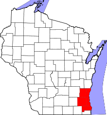
 Location of Muskego in Waukesha County, Wisconsin. | |
| Coordinates: 42°54′4.45″N 88°7′28.7″W / 42.9012361°N 88.124639°WCoordinates: 42°54′4.45″N 88°7′28.7″W / 42.9012361°N 88.124639°W | |
| Country | United States |
| State | Wisconsin |
| County | Waukesha |
| Incorporated | 1964 |
| Government | |
| • Mayor | Kathy Chiaverotti |
| Area[1] | |
| • City | 35.98 sq mi (93.19 km2) |
| • Land | 31.60 sq mi (81.84 km2) |
| • Water | 4.38 sq mi (11.34 km2) |
| Elevation | 801 ft (244 m) |
| Population (2010)[2] | |
| • City | 24,135 |
| • Estimate (2016)[3] | 24,882 |
| • Density | 763.8/sq mi (294.9/km2) |
| • Metro | Part of Metro Milwaukee |
| Time zone | UTC−6 (Central) |
| • Summer (DST) | UTC−5 (Central) |
| Postal Code | 53150 |
| Area code(s) | 414, 262 |
| FIPS code | 55-55275[4] |
| GNIS feature ID | 1570056[5] |
| Website | http://www.cityofmuskego.org |
Muskego is a city in Waukesha County, Wisconsin, United States. As of the 2010 census, the city had a population of 24,135.[4] Muskego is the fifth largest community in Waukesha County. The name Muskego is derived from the Potawatomi Indian name for the area, "Mus-kee-Guaac",[6] meaning sunfish. The Potawatomi were the original inhabitants of Muskego.[7] There are three lakes within the city's boundaries.
History
The history of Muskego started originally as the home of the Potawatomi, who named it "Mus-kee-Guaac", which means "sunfish". The first European came in 1827 and a few years later (1833), the Potawatomi tribe ceded their lands in Wisconsin to the United States government. The first permanent settlers, coming from New Hampshire, were the Luther Parker family.[8]
Once an agricultural area, Muskego was incorporated as a city in 1964. When it became a city it included the unincorporated communities of Tess Corners and Durham Hill. With an increase in housing developments in the city, it has become a bedroom community for Milwaukee.
Muskego Beach Amusement Park
Muskego Beach Amusement Park (1861–1967),[9] later known as DandiLion Park[10] (1968–1977),[9] was a popular amusement park located on the southern bank of Little Muskego Lake. It was at some point home of the world's fastest roller coaster.
Charles Rose, operator of Wisconsin State Fair Park purchased Muskego Beach Amusement Park from Mrs. William Boszhardt in 1944. After World War II, he reopened it. The park included rides, games of chance, and was a venue for musical bands. Charles Rose died in 1963 and five years later, Willard Masterson purchased the park. He renamed it "DandiLion Park" and added more amusement rides, including the Tailspin roller coaster. In 1974, an eleven-year-old boy fell from the Ferris wheel and died.[11]
When Marriott's Great America (now Six Flags Great America) opened in 1976, it lured people away from Muskego and into Gurnee, Illinois. The park was later closed and demolished, and the land was developed into housing.
Geography
According to the United States Census Bureau, the city has a total area of 35.98 square miles (93.19 km2), of which, 31.60 square miles (81.84 km2) is land and 4.38 square miles (11.34 km2) is water.[1]
Muskego contains three lakes within its borders: Big Muskego Lake, Little Muskego Lake, and Lake Denoon.
Big Muskego Lake is a shallow 2,260-acre (9.1 km2) flow-through lake in south-central Muskego. Most of the lake is less than four feet deep with a generally organic or muck bottom. Big Muskego Lake is fringed with cattail-dominated wetlands and encompasses numerous islands of cattail marsh. Bass Bay is a 110-acre (0.45 km2) connected embayment of Big Muskego Lake that has a deeper basin typical of other glacially formed kettle lakes in the region. Bass Bay has a maximum depth of 23 feet (7.0 m) and has a bottom substrate of predominantly muck with some isolated sandy shoreline areas.
Little Muskego Lake is a 506-acre (2.05 km2) flow-through lake with extensive shallow margins and a single deep basin. Located in the northwestern quadrant of the city, the lake has a maximum depth of 65 feet (20 m) and averages 14 feet (4.3 m) deep. The bottom substrate predominantly consists of silt or muck. Residents and visitors to Little Muskego Lake enjoy a variety of lake-related recreational activities, including boating, skiing, sailing, and fishing. The Muskego Waterbugs perform a water ski show in front of Idle Isle Park each Wednesday evening throughout the summer. The lake contains many fish species including: largemouth bass, northern pike, walleye, and several panfish species. Most of the shores of Little Muskego Lake are developed with residential housing.
Lake Denoon is a 162-acre (0.66 km2) lake in the southwestern portion of the city and is also partially located in the Town of Norway, Wisconsin. The lake has a glacially formed kettle basin that reaches a maximum depth of 55 feet (17 m) with bottom substrates varying from sands and gravel to muck. An outlet stream on the south end drains to Ke-Nong-Go-Mong (Long) Lake in Racine County. A cattail island and an extent of cattail shoreline are found on the lake's west end. The remaining lakeshore is mostly developed with residential housing.[12]
A plan to drain the lakes, which were described as a stagnant nuisance, was proposed in 1854.[13]
Demographics
| Historical population | |||
|---|---|---|---|
| Census | Pop. | %± | |
| 1960 | 8,858 | — | |
| 1970 | 11,573 | 30.7% | |
| 1980 | 15,277 | 32.0% | |
| 1990 | 16,813 | 10.1% | |
| 2000 | 21,397 | 27.3% | |
| 2010 | 24,135 | 12.8% | |
| Est. 2016 | 24,882 | [3] | 3.1% |
| U.S. Decennial Census[14] | |||
As of 2000 the median income for a household in the city was $64,247, and the median income for a family was $69,722. Males had a median income of $49,386 versus $30,714 for females. The per capita income for the city was $26,199. About 1.0% of families and 1.6% of the population were below the poverty line, including 1.9% of those under age 18 and 2.8% of those age 65 or over.
2010 census
As of the census[2] of 2010, there were 24,135 people, 9,068 households, and 7,011 families residing in the city. The population density was 763.8 inhabitants per square mile (294.9/km2). There were 9,431 housing units at an average density of 298.4 per square mile (115.2/km2). The racial makeup of the city was 97.2% White, 0.3% African American, 0.2% Native American, 0.9% Asian, 0.4% from other races, and 1.0% from two or more races. Hispanic or Latino of any race were 2.3% of the population.
There were 9,068 households of which 35.7% had children under the age of 18 living with them, 66.6% were married couples living together, 7.0% had a female householder with no husband present, 3.7% had a male householder with no wife present, and 22.7% were non-families. 18.6% of all households were made up of individuals and 8.6% had someone living alone who was 65 years of age or older. The average household size was 2.65 and the average family size was 3.03.
The median age in the city was 42.4 years. 25.1% of residents were under the age of 18; 6.3% were between the ages of 18 and 24; 23.3% were from 25 to 44; 32.4% were from 45 to 64; and 12.9% were 65 years of age or older. The gender makeup of the city was 49.3% male and 50.7% female.
Government
The first Mayor of the city was Jerome Gottfried, elected in 1964. He was followed by Donald Wieselmann, Wayne Salentine, David DeAngelis, Mark Slocomb, Charles Damaske, John Johnson and Kathy Chiaverotti.
Muskego is served by the Tess Corners Fire Department, a volunteer fire department.[15]
Education
Public schools: Muskego-Norway School District:
- Country Meadows Elementary
- Lakeview Elementary (serves Muskego residents, but located in the Town of Norway)
- Mill Valley Elementary
- Muskego Elementary
- Tess Corners Elementary
- Bay Lane Middle School
- Lake Denoon Middle School
- Muskego High School
Parochial schools:
- St. Leonard K-8 Catholic School
- St. Paul's Ev. Lutheran Grade School - WELS
Notable people
- Henry Lockney, Wisconsin State Senator and jurist, born in the town of Muskego.[16]
- Andrija Novakovich, association footballer, born in Muskego.
- Luther Parker, Wisconsin territorial legislator, settler, and pioneer, lived in Muskego.[17]
- Howard Schmidt, cyber security advisor, lived in Muskego.[18]
- Chuck Wichgers, Wisconsin State Assemblyman, lived in Muskego.[19]
See also
References
- 1 2 "US Gazetteer files 2010". United States Census Bureau. Archived from the original on 2012-01-24. Retrieved 2012-11-18.
- 1 2 "American FactFinder". United States Census Bureau. Retrieved 2012-11-18.
- 1 2 "Population and Housing Unit Estimates". Retrieved June 9, 2017.
- 1 2 "American FactFinder". United States Census Bureau. Retrieved 2008-01-31.
- ↑ "US Board on Geographic Names". United States Geological Survey. 2007-10-25. Retrieved 2008-01-31.
- ↑ Topographical map of Wisconsin Territory, 1837 (Morrison). Wisconsin's Water Library: Great Lake Maps. Accessed October 18, 2010.
- ↑ Muskego, WI. Chamber of Commerce
- ↑ http://local.townsquarepublications.com/wisconsin/muskego/history.html
- 1 2 RollerCoaster Database
- ↑ Muskego Historical Society
- ↑ Milwaukee Sentinel July 18, 1974
- ↑ City of Muskego Planning Division
- ↑ "Draining of the Muskego Lake". Milwaukee Daily Sentinel. February 7, 1854. p. 2. Retrieved September 1, 2015 – via Newspapers.com.

- ↑ "Census of Population and Housing". Census.gov. Retrieved June 4, 2015.
- ↑ http://www.ci.muskego.wi.us/Portals/0/docs/CCR2009176.pdf
- ↑ 'Wisconsin Blue Book 1909,' Biographical Sketch of Henry Lockney, pg. 1105
- ↑ Muskego Historical Society-Luther Parker
- ↑ 'Muskego resident, former Obama cyber security chief Schmidt dies at 67, Milwaukee Sentinel Journal, March 2, 2017
- ↑ Rep. Chuck Wichgers
External links
Municipalities and communities of Waukesha County, Wisconsin, United States | ||
|---|---|---|
| Cities |  | |
| Villages | ||
| Towns | ||
| CDP | ||
| Unincorporated communities | ||
| Ghost towns/ neighborhoods | ||
| Footnotes | ‡This populated place also has portions in an adjacent county or counties | |