Jefferson County, Wisconsin
| Jefferson County, Wisconsin | |
|---|---|
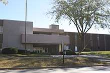 Jefferson County courthouse | |
 Location in the U.S. state of Wisconsin | |
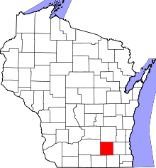
 Wisconsin's location in the U.S. | |
| Founded | 1839 |
| Named for | Jefferson County, New York |
| Seat | Jefferson |
| Largest city | Watertown |
| Area | |
| • Total | 583 sq mi (1,510 km2) |
| • Land | 556 sq mi (1,440 km2) |
| • Water | 26 sq mi (67 km2), 4.5% |
| Population | |
| • (2010) | 83,686 |
| • Density | 150/sq mi (60/km2) |
| Congressional district | 5th |
| Time zone | Central: UTC−6/−5 |
| Website |
www |
Jefferson County is a county in the U.S. state of Wisconsin. As of the 2010 census, the population was 83,686.[1] Its county seat is Jefferson.[2]
Jefferson County comprises the Watertown-Fort Atkinson, WI Micropolitan Statistical Area, which is also included in the Milwaukee-Racine-Waukesha, WI Combined Statistical Area.
History
Jefferson County was created in 1836 as part of Wisconsin Territory and was organized in 1839.[3] It was named after Jefferson County, New York, where some of the original settlers came from.[4] The town of Watertown, Wisconsin was named after Watertown, New York in Jefferson County, New York.
Geography
According to the U.S. Census Bureau, the county has an area of 583 square miles (1,510 km2), of which 556 square miles (1,440 km2) is land and 26 square miles (67 km2) (4.5%) is water.[5]
Major highways
Airports
- Watertown Municipal Airport (KRYV) provides services for the county and surrounding communities.
- Fort Atkinson Municipal Airport (61C), enhances county service.
Adjacent counties
- Dodge County - north
- Waukesha County - east
- Walworth County - southeast
- Rock County - southwest
- Dane County - west
Demographics
| Historical population | |||
|---|---|---|---|
| Census | Pop. | %± | |
| 1840 | 914 | — | |
| 1850 | 15,317 | 1,575.8% | |
| 1860 | 30,438 | 98.7% | |
| 1870 | 34,040 | 11.8% | |
| 1880 | 32,156 | −5.5% | |
| 1890 | 33,530 | 4.3% | |
| 1900 | 34,789 | 3.8% | |
| 1910 | 34,306 | −1.4% | |
| 1920 | 35,022 | 2.1% | |
| 1930 | 36,785 | 5.0% | |
| 1940 | 38,868 | 5.7% | |
| 1950 | 43,069 | 10.8% | |
| 1960 | 50,094 | 16.3% | |
| 1970 | 60,060 | 19.9% | |
| 1980 | 66,152 | 10.1% | |
| 1990 | 67,783 | 2.5% | |
| 2000 | 74,021 | 9.2% | |
| 2010 | 83,686 | 13.1% | |
| Est. 2016 | 84,625 | [6] | 1.1% |
| U.S. Decennial Census[7] 1790–1960[8] 1900–1990[9] 1990–2000[10] 2010–2014[1] | |||
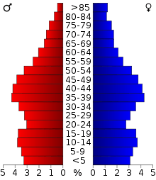
As of the census[11] of 2010, there were 83,686 people, 32,117 households, and 21,872 families residing in the county. The population density was 133 people per square mile (51/km²). There were 30,092 housing units at an average density of 54 per square mile (21/km²). The county's racial makeup was 96.34% White, 0.28% Black or African American, 0.34% Native American, 0.45% Asian, 0.02% Pacific Islander, 1.65% from other races, and 0.93% from two or more races. 4.09% of the population were Hispanic or Latino of any race. 55.1% were of German, 6.1% Norwegian, 6.0% Irish and 5.1% American ancestry according to Census 2000.
There were 28,205 households out of which 33.20% had children under the age of 18 living with them, 58.50% were married couples living together, 8.20% had a female householder with no husband present, and 29.50% were non-families. 23.60% of all households were made up of individuals and 9.60% had someone living alone who was 65 years of age or older. The average household size was 2.55 and the average family size was 3.02.
In the county, the population was spread out with 25.20% under the age of 18, 8.50% from 18 to 24, 30.40% from 25 to 44, 23.20% from 45 to 64, and 12.60% who were 65 years of age or older. The median age was 37 years. For every 100 females there were 98.40 males. For every 100 females age 18 and over, there were 96.80 males.
The Dwight Foster Public Library, which serves as the resource library for the county, [12] had a total service population of 19,095 in 2010.[13] It is a member of the Bridges Library System.
Government
The County Board of Supervisors, with 30 members, serves as the legislative body for the county. There are seven elected officials in addition to the County Board of Supervisors. County-wide partisan elections are held in November. The County Board's members are elected for two-year terms during a spring non-partisan election. The County Board is responsible for the county administrator. The County Board elects a chairman, vice-chairman, and second vice-chairman.
Politics
| Year | Republican | Democratic | Third parties |
|---|---|---|---|
| 2016 | 54.3% 23,417 | 38.4% 16,569 | 7.3% 3,123 |
| 2012 | 53.1% 23,517 | 45.5% 20,158 | 1.4% 606 |
| 2008 | 48.9% 21,096 | 49.7% 21,448 | 1.4% 622 |
| 2004 | 56.5% 23,776 | 42.6% 17,925 | 1.0% 414 |
| 2000 | 53.2% 19,204 | 42.1% 15,203 | 4.7% 1,692 |
| 1996 | 42.6% 12,681 | 44.3% 13,188 | 13.1% 3,905 |
| 1992 | 39.9% 13,072 | 35.3% 11,593 | 24.8% 8,137 |
| 1988 | 54.3% 14,309 | 44.9% 11,816 | 0.8% 217 |
| 1984 | 61.8% 17,780 | 37.5% 10,788 | 0.8% 216 |
| 1980 | 53.9% 16,174 | 37.8% 11,335 | 8.3% 2,491 |
| 1976 | 53.9% 15,528 | 43.7% 12,577 | 2.5% 707 |
| 1972 | 59.5% 14,621 | 37.8% 9,303 | 2.7% 663 |
| 1968 | 55.0% 12,478 | 38.4% 8,716 | 6.6% 1,504 |
| 1964 | 39.6% 8,741 | 60.2% 13,295 | 0.2% 48 |
| 1960 | 61.6% 14,133 | 38.2% 8,757 | 0.2% 39 |
| 1956 | 67.0% 13,357 | 32.4% 6,452 | 0.6% 122 |
| 1952 | 66.9% 13,884 | 32.9% 6,827 | 0.2% 32 |
| 1948 | 52.4% 8,244 | 46.1% 7,256 | 1.5% 228 |
| 1944 | 59.2% 10,245 | 40.4% 6,988 | 0.5% 84 |
| 1940 | 56.0% 10,178 | 43.2% 7,842 | 0.8% 149 |
| 1936 | 32.3% 5,599 | 64.3% 11,144 | 3.4% 581 |
| 1932 | 30.8% 5,062 | 68.3% 11,230 | 1.0% 156 |
| 1928 | 57.3% 8,612 | 41.9% 6,305 | 0.8% 116 |
| 1924 | 31.2% 4,250 | 10.1% 1,374 | 58.7% 7,987 |
| 1920 | 80.4% 8,865 | 16.7% 1,844 | 2.9% 320 |
| 1916 | 49.6% 3,785 | 47.7% 3,645 | 2.7% 206 |
| 1912 | 27.4% 1,926 | 62.4% 4,381 | 10.2% 714 |
| 1908 | 40.4% 3,207 | 56.6% 4,492 | 2.9% 233 |
| 1904 | 47.7% 3,669 | 49.1% 3,778 | 3.2% 249 |
| 1900 | 46.3% 3,729 | 51.2% 4,127 | 2.6% 207 |
| 1896 | 52.6% 4,344 | 42.4% 3,504 | 5.0% 409 |
| 1892 | 35.4% 2,679 | 61.5% 4,661 | 3.1% 235 |
Communities
Cities
- Fort Atkinson
- Jefferson (county seat)
- Lake Mills
- Waterloo
- Watertown (partly in Dodge County)
- Whitewater (mostly in Walworth County)
Villages
- Cambridge (mostly in Dane County)
- Johnson Creek
- Lac La Belle (mostly in Waukesha County)
- Palmyra
- Sullivan
Towns
Census-designated places
Unincorporated communities
- Aztalan
- Blackhawk Island
- Busseyville
- Carcajou
- Cold Spring
- Concord
- Ebenezer
- Farmington
- Glenn Oaks Beach
- Heath Mills
- Hoopers Mill
- Hubbleton
- Jefferson Junction
- Koshkonong (partial)
- Koshkonong Manor
- Koshkonong Mounds
- Kroghville
- Lake Lac La Belle
- London (partial)
- Milford
- North Shore
- Oakland
- Pipersville
- Portland (partial)
- Slabtown
- Sylvan Mounds
- Vinnie Ha Ha
See also
References
- 1 2 "State & County QuickFacts". United States Census Bureau. Archived from the original on July 12, 2011. Retrieved January 21, 2014.
- ↑ "Find a County". National Association of Counties. Archived from the original on 2011-05-31. Retrieved 2011-06-07.
- ↑ "Wisconsin: Individual County Chronologies". Wisconsin Atlas of Historical County Boundaries. The Newberry Library. 2007. Retrieved August 14, 2015.
- ↑ "Term: Jefferson County [origin of place name]" in Dictionary of Wisconsin History.
- ↑ "2010 Census Gazetteer Files". United States Census Bureau. August 22, 2012. Retrieved August 5, 2015.
- ↑ "Population and Housing Unit Estimates". Retrieved June 9, 2017.
- ↑ "U.S. Decennial Census". United States Census Bureau. Archived from the original on May 12, 2015. Retrieved August 5, 2015.
- ↑ "Historical Census Browser". University of Virginia Library. Retrieved August 5, 2015.
- ↑ Forstall, Richard L., ed. (March 27, 1995). "Population of Counties by Decennial Census: 1900 to 1990". United States Census Bureau. Retrieved August 5, 2015.
- ↑ "Census 2000 PHC-T-4. Ranking Tables for Counties: 1990 and 2000" (PDF). United States Census Bureau. April 2, 2001. Retrieved August 5, 2015.
- ↑ "American FactFinder". United States Census Bureau. Retrieved 2011-05-14.
- ↑ "Jefferson County Library Service". Retrieved 24 April 2012.
- ↑ "Wisconsin Public Library Service Data, 2010" (PDF). Department of Public Instruction. Archived from the original (PDF) on 2012-03-06.
- ↑ Leip, David. "Dave Leip's Atlas of U.S. Presidential Elections". uselectionatlas.org. Retrieved 8 April 2018.
External links
| Wikimedia Commons has media related to Jefferson County, Wisconsin. |
- Jefferson County
- Daily Jefferson County Union newspaper
Places adjacent to Jefferson County, Wisconsin | ||||||||||
|---|---|---|---|---|---|---|---|---|---|---|
| ||||||||||
Municipalities and communities of Jefferson County, Wisconsin, United States | ||
|---|---|---|
| Cities | | |
| Villages | ||
| Towns | ||
| CDPs | ||
| Unincorporated communities |
| |
| Footnotes | ‡This populated place also has portions in an adjacent county or counties | |
