Ashland, Wisconsin
| Ashland, Wisconsin | ||
|---|---|---|
| City | ||
| ||
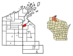 Location of Ashland in Ashland County and Bayfield County, Wisconsin | ||
| Coordinates: 46°35′24″N 90°52′48″W / 46.59000°N 90.88000°WCoordinates: 46°35′24″N 90°52′48″W / 46.59000°N 90.88000°W | ||
| Country | United States | |
| State | Wisconsin | |
| Counties | Ashland, Bayfield | |
| Government | ||
| • Mayor | Debra Lewis | |
| Area[1] | ||
| • Total | 13.62 sq mi (35.28 km2) | |
| • Land | 13.38 sq mi (34.67 km2) | |
| • Water | 0.24 sq mi (0.62 km2) | |
| Elevation | 671 ft (205 m) | |
| Population (2010)[2] | ||
| • Total | 8,216 | |
| • Estimate (2016)[3] | 7,957 | |
| • Density | 594.47/sq mi (229.53/km2) | |
| Time zone | UTC−6 (CST) | |
| • Summer (DST) | UTC−5 (CDT) | |
| ZIP code | 54806 | |
| Area code(s) | 715 & 534 | |
| FIPS code | 55-03225[4] | |
| GNIS feature ID | 1560982[5] | |
| Website |
www | |

Ashland is a city in Ashland and Bayfield counties in the U.S. state of Wisconsin. The city is a port on Lake Superior, near the head of Chequamegon Bay. The population was 8,216 at the 2010 census, all of which resided in the Ashland County portion of the city. The decently-sized unpopulated Bayfield County portion is located in the city's southwest, bordered by the easternmost part of the Town of Eileen.
The city is situated at the junction of U.S. Route 2 and Wisconsin Highway 13. It is the home of Northland College, Wisconsin Indianhead Technical College, and the Sigurd Olson Environmental Institute.
History
Pre-settlement
Four flags have flown over the area around Ashland: Spanish, French, English and American. Eight Indian nations have lived on Chequamegon Bay. Later settlers included European explorers, missionaries and fur traders, and more recently, Yankees who platted and developed the lands, railroaders, shippers, loggers, entrepreneurs, and other settlers. The area was part of the Northwest Territory and was subsequently part of four successive territories before becoming part of the state of Wisconsin: Indiana Territory, Michigan Territory, Illinois Territory, and Wisconsin Territory.
About the time Christopher Columbus arrived in the New World, the Ojibwe people came to the land they called Sha-ga-waun-il-ong. This term has been translated numerous ways: "lowlands", the "needle", "the region of shallow water", and where "there are large extended breakers". Each is descriptive and suitably accurate.
The Ojibwe stayed on Chequamegon Point for about a century before leaving, first to settle on Madeline Island and then to move to the Sault region.
French fur traders Pierre d'Esprit, le Sieur Radisson and Medard Chouart, le Sieur des Groseillers were the first Europeans of record to visit Chequamegon Bay. They arrived in 1659 and built what has been called the first European dwelling place in Wisconsin. A historical marker is located at Maslowski Beach on U.S. Route 2 on the west end of Ashland. The monument was erected in 1929 by the Old Settlers Club.
The Ojibwe heartily welcomed the Frenchmen. Five years later, Father Claude-Jean Allouez arrived. A Jesuit missionary, he brought the first word of Christianity to Wisconsin's shores. Allouez built a chapel not far from Radisson's and Groseillier's stockade and remained at the Bay until 1669.
Settlement
In 1854, Ohioans Asaph Whittlesey and George Kilborn set out from La Pointe to explore the head of Chequamegon Bay. Whittlesey built a 10 ft (3.0 m) × 14 ft (4.3 m) cabin in Ashland. His wife, Lucy, and daughter, Eugenia, joined him in August and prepared to winter in their new home. Signs of civilization quickly followed. The first community dance was held at their house. The Reverend L.H. Wheeler preached the first sermon on the first Independence Day that was observed there. It was the location of the first post office and polling place for county offices. Sunday school was also conducted on the premises.
Tar and feather attacks during World War I
During World War I there were at least six incidents of vigilantism in the Ashland area against men suspected of pro-German sympathies. Citizens were abducted at night from their homes by mobs of masked men who drove their captives to secluded areas where they were tarred and feathered. A group calling themselves the Knights of Liberty claimed responsibility for the attacks, stating in a letter to a local paper "We have no purpose to do injustice to any man, but we do feel that any treasonable and seditious acts, or utterances, demand prompt punishment. These cases must not be allowed to run indefinitely, without anything being done. We want action and we want it now."[6]
Victims included:
- Professor E. A. Schimler, abducted, tarred and feathered on March 31, 1918. Born in Germany, Schimler taught French at local Northland College. He was unable to identify any of his assailants.[7]
- Bartender Adolph Anton, taken from his home on April 9 and stripped, tarred and feathered for his suspected "pro-Germanism".[8] Anton claimed to recognize two of the men, Ephraim Gay and George Buchanan, who were arrested, pleaded not guilty and released on their own recognizance.[9] A municipal judge dismissed the cases at the preliminary hearing in July.[10] Anton had since left town for Gary, Indiana.[11][12]
- William Landraint, 62, was seized in front of a downtown hotel by a mob of fifty men who put a bag over his head, handcuffed him and drove him to the country where he was tarred and feathered. Of German birth, Landraint was a deputy tax assessor who had lost his job due to suspected disloyalty.[13][14] Despite dozens of witnesses to the kidnapping by unmasked men, no one claimed to know any of the participants.[15] Landraint later asked for police protection after receiving a threatening letter. He soon left town for St. Paul, Minnesota.[16]
- In early June 1918 Emil Kunze went to Ashland police headquarters to report hearing men outside his home conspiring to tar and feather him for his alleged pro-Germanism. He asked for permission to sleep in the jail. He later quit his truck driving job and left town.[17]
- In early July 1918 farmer Martin Johnson of nearby Sweden, Wisconsin was visited at his home by men asking assistance in locating a nearby fishing stream. Once away from the house Johnson was driven to a secluded area, stripped, tarred and feathered.[18]
- On October 25, 1918, a farmer living eight miles outside Ashland, John Oestrycher, was tarred and feathered for not buying Liberty Bonds and being "pro-German."[19]
Governor Emanuel Philipp expressed his indignation over the incidents and the reports of local citizens of German descent receiving threatening letters. He directed state Attorney General Spencer Haven to launch an inquiry. His investigator found the local citizenry uncooperative, including John C. Chapple, editor of the Ashland Daily Press and campaign manager for super-patriot Republican candidate for governor Roy P. Wilcox.[20] The inquiry found the community generally satisfied with the treatment of the first victims.[21] Haven expressed frustration at the local court that refused to adjourn for the securing of evidence, and at the district attorney who dismissed the first two cases for lack of said evidence. Haven threatened to send a company of the state guard to maintain law and order.[22] Ultimately there were no convictions for any of the attacks. Two months after the world war ended reports appeared that the local Knights of Liberty had disbanded. The Milwaukee Journal reported that more than 800 men in Ashland County belonged to the order.[23][24]
Dates of note
- 1856 — First plat of Ashland registered
- 1870 — First Ashland brownstone quarried and shipped
- 1872 — First sawmill built by W.R. Sutherland
- 1872 — The Ashland Weekly Press is founded by Sam Fifield. It became a daily paper, over a decade later. The first issue of the Ashland Daily Press was March 5, 1888.
- 1874 — First brewery built, Ashland Brewing Company
- 1877 — Wisconsin Central Railroad connected Ashland to Chicago
- 1877 — Chequamegon Hotel opened, one block from current hotel
- 1887 — State legislature incorporated the City of Ashland
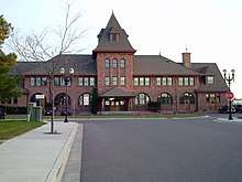
- 1889 — Wisconsin Central Depot constructed
- 1892 — Northern Wisconsin Academy opened (now Northland College)
- 1892 — Ashland Post Office built
- 1904 — Ashland High School opened
- 1929 — First airport opened
- 1940 — WATW radio went on the air
- 1970 — Establishment of the Apostle Islands National Lakeshore
- 1972 — Memorial Medical Center opened
- 1979 — The Union Depot is listed on the National Register of Historic Places.
- 1984 — The West Second Street Historic District is listed on the National Register of Historic Places. Second Street was later renamed Main Street.
- 1998 — Northern Great Lakes Visitor Center is built
- 2009 — Ore dock slated for demolition. Attempts by some community members to help save the historic structure were not successful.
- 2014 — The Chapple and MacArthur Avenues Residential Historic District is listed on the National Register of Historic Places.
- 2016 — New fire hall dedicated, replacing the historic century-old Ellis Fire Station.
- 2016 — From July 11 until August, Ashland suffered one of the worst storm seasons in its history, destroying highways that go to Ironwood and Marengo, as well as destroying a huge part of the Saxon Harbor, and flooding many basements. Three deaths were reported.
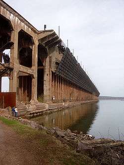
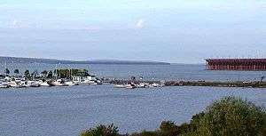
Ore dock
The harbor of Ashland was dominated by the massive Wisconsin Central Railway (later Soo Line) ore dock, built in 1916 to load iron ore mined in the area into freighters bound for ports in the Rust Belt.[25] The last of what were once many such docks, the concrete structure is 80 feet (24 m) high and 75 feet (23 m) wide and in 1925 the dock was extended to 1,800 feet (550 m); it was last used to ship ore in 1965.[26] In 2007 the Wisconsin Trust for Historic Preservation named it one of the "10 most endangered historic buildings in Wisconsin", a list intended to stir preservation efforts.[26] The main concrete structure and trestle slowly deteriorated since the early 1970s because of lack of maintenance and the effects of the environment.[27] A structural inspection completed in 2006 and 2007 concluded that the ore dock had become structurally unsafe and was an imminent safety hazard. On May 14, 2009, the Ashland Planning Commission granted Canadian National Railway approval for the demolition. All material on the ore dock was removed down to the concrete base.[28] This was completed in 2013.
The base of the ore dock remains. The city took ownership of it from Canadian National Railway in May, 2014. It is working with a consultant group to design a redevelopment plan for the base of the dock.[29][30]
Geography
Ashland is located along the south shore of Chequamegon Bay. According to the United States Census Bureau, the city has a total area of 13.70 square miles (35.48 km2), of which 13.42 square miles (34.76 km2) is land and 0.28 square miles (0.73 km2) is water.[31]
Climate
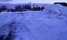
There are four distinct seasons, with notably cold winters. Due to its proximity to Lake Superior, lake effect snow is sometimes a phenomenon in Ashland.
| Climate data for Ashland, Wisconsin (KASX, 1981–2010 normals, extremes 1893–present[32] | |||||||||||||
|---|---|---|---|---|---|---|---|---|---|---|---|---|---|
| Month | Jan | Feb | Mar | Apr | May | Jun | Jul | Aug | Sep | Oct | Nov | Dec | Year |
| Record high °F (°C) | 58 (14) |
62 (17) |
84 (29) |
91 (33) |
96 (36) |
99 (37) |
107 (42) |
103 (39) |
100 (38) |
94 (34) |
74 (23) |
60 (16) |
107 (42) |
| Average high °F (°C) | 22.3 (−5.4) |
27.1 (−2.7) |
37.1 (2.8) |
51.1 (10.6) |
64.9 (18.3) |
72.9 (22.7) |
78.0 (25.6) |
76.9 (24.9) |
68.4 (20.2) |
54.6 (12.6) |
39.3 (4.1) |
26.0 (−3.3) |
51.7 (10.9) |
| Average low °F (°C) | 4.3 (−15.4) |
8.4 (−13.1) |
17.2 (−8.2) |
28.1 (−2.2) |
38.8 (3.8) |
48.3 (9.1) |
54.9 (12.7) |
52.6 (11.4) |
45.0 (7.2) |
34.4 (1.3) |
23.5 (−4.7) |
10.8 (−11.8) |
30.6 (−0.8) |
| Record low °F (°C) | −41 (−41) |
−40 (−40) |
−30 (−34) |
−5 (−21) |
16 (−9) |
23 (−5) |
32 (0) |
29 (−2) |
12 (−11) |
0 (−18) |
−16 (−27) |
−32 (−36) |
−41 (−41) |
| Average precipitation inches (mm) | 0.79 (20.1) |
0.74 (18.8) |
1.34 (34) |
2.54 (64.5) |
3.07 (78) |
3.82 (97) |
4.29 (109) |
3.55 (90.2) |
3.85 (97.8) |
3.28 (83.3) |
1.82 (46.2) |
0.78 (19.8) |
29.87 (758.7) |
| Source: NOAA[33][34] | |||||||||||||
Demographics
| Historical population | |||
|---|---|---|---|
| Census | Pop. | %± | |
| 1890 | 9,956 | — | |
| 1900 | 13,074 | 31.3% | |
| 1910 | 11,594 | −11.3% | |
| 1920 | 11,334 | −2.2% | |
| 1930 | 10,622 | −6.3% | |
| 1940 | 11,101 | 4.5% | |
| 1950 | 10,640 | −4.2% | |
| 1960 | 10,132 | −4.8% | |
| 1970 | 9,615 | −5.1% | |
| 1980 | 9,115 | −5.2% | |
| 1990 | 8,695 | −4.6% | |
| 2000 | 8,620 | −0.9% | |
| 2010 | 8,216 | −4.7% | |
| Est. 2016 | 7,957 | [3] | −3.2% |
| U.S. Decennial Census[35] | |||
2010 census
As of the census[2] of 2010, there were 8,216 people, 3,516 households, and 1,942 families residing in the city. The population density was 612.2 inhabitants per square mile (236.4/km2). There were 3,864 housing units at an average density of 287.9 per square mile (111.2/km2). The racial makeup of the city was 87.0% White, 0.5% African American, 7.5% Native American, 0.5% Asian, 0.5% from other races, and 4.0% from two or more races. Hispanic or Latino of any race were 2.1% of the population.
There were 3,516 households of which 26.6% had children under the age of 18 living with them, 37.7% were married couples living together, 12.6% had a female householder with no husband present, 4.9% had a male householder with no wife present, and 44.8% were non-families. 36.7% of all households were made up of individuals and 14.4% had someone living alone who was 65 years of age or older. The average household size was 2.17 and the average family size was 2.81.
The median age in the city was 38.6 years. 21% of residents were under the age of 18; 13% were between the ages of 18 and 24; 23.1% were from 25 to 44; 26.7% were from 45 to 64; and 16.3% were 65 years of age or older. The gender makeup of the city was 48.2% male and 51.8% female.
2000 census
As of the census of 2000, there were 8,620 people, 3,513 households, and 2,027 families residing in the city. The population density was 643.3 people per square mile (248.4/km²). There were 3,777 housing units at an average density of 108.8 persons/km² (281.9 persons/sq mi). The racial makeup of the city was 90.17% White, 0.32% African American, 6.30% Native American, 0.49% Asian, 0.06% Pacific Islander, 0.43% from other races, and 2.23% from two or more races. 1.37% of the population were Hispanic or Latino of any race.
There were 3,513 households out of which 28.3% had children under the age of 18 living with them, 42.5% were married couples living together, 11.7% have a woman whose husband does not live with her, and 42.3% were non-families. 35.6% of all households were made up of individuals and 16.3% had someone living alone who was 65 years of age or older. The average household size was 2.24 and the average family size was 2.91.
In the city, the population was spread out with 22.2% under the age of 18, 15.4% from 18 to 24, 24.7% from 25 to 44, 20.1% from 45 to 64, and 17.6% who were 65 years of age or older. The median age was 36 years. For every 100 females, there were 91.2 males. For every 100 females age 18 and over, there were 84.8 males.
The median income for a household in the city was $30,853, and the median income for a family was $40,549. Males had a median income of $30,122 versus $20,926 for females. The per capita income for the city was $16,330. About 7.5% of families and 12.7% of the population were below the poverty line, including 9.9% of those under the age of 18 and 10.0% ages 65 or older.
Government
Ashland has a mayor-council form of government. Debra Lewis was the first woman elected mayor in the 2014 election. The city's 11 wards are each represented by an elected alderperson (or councilor).[36] City council meetings are held on the second and last Tuesday of the month.[36] Meetings are open to the public, although on occasion the Council may meet in closed session.
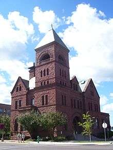
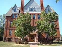
Ashland City Hall, which was built in 1893, was originally used as the city's first post office. It is listed on the National Register of Historic Places as the "Old Ashland Post Office". The County Courthouse is also located in the city.
In the Wisconsin State Legislature, Ashland is located in the 74th Assembly District, and the 25th Senate District, represented by Assembly Representative Beth Meyers and State Senator Janet Bewley.
In the United States House of Representatives, Ashland is served by Sean Duffy, of Wisconsin's 7th congressional district.
Economy
A few largest manufacturers in the community include:
- Bretting Manufacturing, equipment manufacturer
- Larson-Juhl, manufacturer of picture frames, a subsidiary of Berkshire Hathaway
- H Windows, window manufacturer
Many small businesses also make up a large portion of the local economy. Tourism is an important part of the area's commerce.
Education
Public schools
- Lake Superior Primary/Intermediate/Charter School
- Marengo Valley Elementary School
- Ashland Middle School
- Ashland High School/Ashland Charter High School
Private schools
- Ashland Seventh-day Adventist School
- Celebration Christian Academy
- Our Lady of the Lake School
- Zion Lutheran Christian School
Colleges
Media
News media
- Ashland Daily Press, local daily print publication
- Bottom Line News and Views
- Lake Superior Sounder (closed in January 2008)
Radio
- WATW 1400 AM - Conservative talk radio
- WUWS 90.9 FM — Ideas network of Wisconsin Public Radio
- WJRF 91.5 FM - Christian radio
- WBSZ 93.3 FM - Country music
- WWMD-LP 95.5FM - Christian talk radio (Catholic)
- WJJH 96.7 FM - Rock music
- WRNC-LP 97.7 FM - Freeform radio station operated by Northland College
- WIMI 99.7 FM - Adult Contemporary music (Broadcast from Ironwood, MI)
- W284AN 104.7 FM - News and Classical Musical network of Wisconsin Public Radio
- WEGZ 105.9 FM - Christian talk radio (broadcast from Washburn, WI)
- WNXR 107.3 FM - Oldies (broadcast from Iron River, WI)
Television
Stations serving Ashland come from the Duluth market:
Transportation
The two major highways in the city are U.S. Highway 2 and Wisconsin Highway 13. The city is one of the northern termini in Wisconsin for the Canadian National Railway, parent company of the former Wisconsin Central Ltd., which assumed the former Soo Line tracks in 1987.[37]
Airports
Airports certified for commercial carrier operations near Ashland:
- Gogebic-Iron County Airport (about 54 miles (87 km); Ironwood, Michigan)
- Duluth International Airport (about 92 miles (148 km); Duluth, Minnesota)
- Rhinelander-Oneida County Airport (KRHI) (about 119 miles (192 km); Rhinelander, Wisconsin)
Other public use airports near Ashland:
- John F. Kennedy Memorial Airport (KASX) (about 2 miles (3.2 km); Ashland, Wisconsin)
- Madeline Island Airport (about 17 miles (27 km); La Pointe, Wisconsin)
- Cable Union Airport (about 37 miles (60 km); Cable, Wisconsin)
- Park Falls Municipal Airport (KPKF) (about 58 miles (93 km); Park Falls, Wisconsin)
Public transit
Local transportation is provided by the non-profit Bay Area Rural Transit (BART) system, which has bus stops throughout the community. Headquartered in Ashland's Industrial Park, BART also provides transportation to and from other communities in the Chequamegon Bay region, including Washburn, and Bayfield.
Northern Towns Transport is a regional car service and shuttle provider, connecting Ashland and the Chequamegon Bay area with downtown Minneapolis, Minnesota and Minneapolis-St. Paul International Airport; as well as the Twin Ports of Superior, Wisconsin / Duluth, Minnesota and Duluth International Airport.
Churches
- Trinity Evangelical Lutheran Church of the Wisconsin Evangelical Lutheran Synod (WELS)[38]
- Our Lady of the Lake Catholic Community
- Chequamegon Unitarian Universalist Fellowship
- Saron Lutheran Church
- Good Shepard Lutheran Church
- Zion Lutheran Church
- First English Lutheran Church
- Salem Baptist Church
- Lighthouse Baptist Church
- Saint Andrew's Episcopal Church
- Church of Jesus Christ of Latter-Day Saints
- Jehovah's Witnesses
- First Assembly of God Church
- Seventh-day Adventist Church
- United Methodist Church
- First Covenant Church
- Calvary Tabernacle United Pentecostal
- Celebration Fellowship
- United Presbyterian Congregational Church
Arts and culture
The region is served by the Chequamegon Bay Arts Council, a non-profit organization promoting the arts in northern Wisconsin.
The Ashland Chamber Music Society is a volunteer organization that provides a venue for local and regional musicians to perform chamber music in the Ashland area.
The Bay Area Film Society is a group of film enthusiasts who sponsor the screening of classic films.
The Chequamegon Symphony Orchestra (CSO) provides enriching, engaging, and entertaining orchestral concerts to the residents of northern Wisconsin.
Recreation
Natural places in the vicinity include Lake Superior, the Whittlesey Creek National Wildlife Refuge, and the nearby Chequamegon-Nicolet National Forest.
Parks
- Bayview Park, also known as Pamida Beach, contains a swimming beach, bathrooms, fishing pier, picnic area and playground. The 10-mile walking trail that loops Ashland connects to the park.[39] Bayview Park is the only swim front in Ashland that provides lifeguards in the summer.
- Beaser Park
- Kreher Park, also known as Sunset Park, contains 33 RV campsites on lake Superior. The park has a swimming beach, playground, showers, dumping station, and firewood. The park connect to the Ashland Waterfront trail.[39]
- Maslowski Beach features a shallow, sandy swimming beach, playground, pavilion, bathrooms, changing rooms, pay phone and artesian well. There is also access to Ashland's Lake Front Trail along Chequamegon Bay.[39]
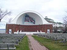
- Memorial Park contains a band shell.[39]
- Menard Park[39]
- Prentice Park is the largest of Ashland's 12 parks, at approximately 100 acres. It is a natural habitat for migrating birds, a nesting ground for mute swans, with hiking trails, artesian wells, a picnic area, a children's playground, and tent camping.[39]
Hiking and biking trails
- Tri-County Corridor
- Lakefront Trail, along Lake Superior
- There is a recreational trail that loops around the entire city.
- North Country Trail
Boating
- Ashland Marina, located behind the Hotel Chequamegon
Camping
Local attractions
- Ashland Historical Museum
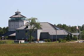
- Northern Great Lakes Visitor Center - a regional information center with natural history exhibits. A branch office of the Wisconsin Historical Society is located upstairs.
- The Chequamegon Theatre Association is located in the historic Rhinehart Theatre.
- Ashland Chequamegon Bay Golf Course
Events
- Bay Days is Ashland's annual community festival, held every year in the middle of July. In addition to street vendors and live outdoor music, other happenings include a "Strongest Man in the Bay Contest" and a Sprint Triathlon.
- The Book Across the Bay ski race is held every year in February. The course for the race crosses the frozen Chequamegon Bay of Lake Superior, starting in Ashland, and ending in Washburn.
- The WhistleStop Marathon and half-marathon is held every fall, and draws athletes from surrounding regions. The before-race events include a pasta feed, and live music the night before.
- Live chamber music concerts performed by the Ashland Chamber Music Society
- The annual Red Clay Classics car race held at ABC Raceway
- The Ashland Area Farmer's Market is held in the summer on Saturday mornings.
- Holiday parades include a Fourth of July parade, a Christmas parade, and a Homecoming parade.
- The Ashland County Fair is usually held in September at the fairgrounds in Marengo.
- The Superior Vistas Bike Tour is held in June.
- The Chequamegon Bay Bird & Nature Festival is held in May.
- Garland City Women's Expo is held in November.
- Chick-uamegon 5k & 10k run
Notable people
- Ove H. Berg, Wisconsin State Assemblyman
- Janet Bewley, member of the Wisconsin Legislature
- Abe L. Biglow, Wisconsin State Assemblyman
- Bob Blake, NHL player
- Bob Brevak, racing driver
- F. Taylor Brown, U.S. Navy admiral
- Ray Callahan, MLB pitcher for the Cincinnati Reds
- John C. Chapple, Wisconsin State Assemblyman and newspaper editor
- Moose Cochran, NFL player
- Norm DeBriyn, former head coach of the Arkansas Razorbacks baseball team
- Sean Duffy, U.S. Congressman
- Sam Fifield, 14th Lieutenant Governor of Wisconsin, and noted businessman
- Moose Gardner, professional football player
- Bernard E. Gehrmann, Wisconsin State Assemblyman
- Morgan Hamm, Olympic medalist
- Paul Hamm, world champion gymnast, Olympic gold medalist
- Everis A. Hayes, U.S. Representative from California
- Andrew R. Johnson (1856–1933), Louisiana state senator from 1916 to 1924 and mayor of Homer, Louisiana, lived in Ashland while working in the 1890s for the United States Land Office. In 1901, he named the village of Ashland, Louisiana, for Ashland, Wisconsin.
- John Kingston, Jr., Wisconsin State Senator
- Jim Kisselburgh, football player
- Clarence A. Lamoreux, Wisconsin State Senator
- Lawrence A. Lamoreux, Wisconsin State Assembly
- William D. Leahy, U.S. Navy Fleet Admiral, first military officer to reach a five-star rank; Chief of Naval Operations; Governor of Puerto Rico; U.S. Ambassador to France; White House Chief of Staff for Franklin D. Roosevelt and Harry S. Truman
- Michael A. McAuliffe, U.S. Air Force Brigadier General
- Robert Bruce McCoy, U.S. National Guard Major General
- George F. Merrill, Wisconsin State Senator
- Jennifer Ouellette, Science Writer
- Sigurd F. Olson, author
- William Plizka, member of the Wisconsin Legislature
- Joe Rogalski, MLB player
- Albert W. Sanborn, Wisconsin State Senator
- John C. Sibbald, Wisconsin State Assemblyman
- John W. Slaby, Wisconsin State Assemblyman
- Dave Suminski, NFL player
- John Szarkowski, photographer
- Justus Smith Stearns, businessman
- Daniel Theno, Wisconsin State Senator, Ashland Mayor
- A. Pearce Tomkins, Wisconsin State Senator
- Harry P. Van Guilder, Wisconsin State Assemblyman
References
- ↑ "2016 U.S. Gazetteer Files". United States Census Bureau. Retrieved Jul 19, 2017.
- 1 2 "American FactFinder". United States Census Bureau. Retrieved 2012-11-18.
- 1 2 "Population and Housing Unit Estimates". Retrieved June 9, 2017.
- ↑ "American FactFinder". United States Census Bureau. Archived from the original on 2013-09-11. Retrieved 2008-01-31.
- ↑ "US Board on Geographic Names". United States Geological Survey. 2007-10-25. Retrieved 2008-01-31.
- ↑ "Investigating Feather Party". Eau Claire Leader, April 26, 1918.
- ↑ "Tar and Feather Ashland Teacher". Rhinelander New North, April 4, 1918.
- ↑ "Ashland Man is Punished by Crowd". The Capital Times, April 11, 1918.
- ↑ "Citizens Block Inquiry, Charge". Wisconsin State Journal, April 27, 1918.
- ↑ "Promises More Tar Bees at Ashland". The Capital Times, July 18, 1918, p. 2. "The case was given a preliminary hearing at Ashland on Tuesday and Wednesday, which resulted in the municipal judge dismissing the cases."
- ↑ "Tar and Feather Artists are Acquitted of Charge". Eau Claire Leader, July 18, 1918.
- ↑ Grand Rapids Tribune, July 25, 1918.
- ↑ "Ashland Tells Philipp of 3rd Tar Bee". The Capital Times, May 9, 1918.
- ↑ "Another Tar and Feather Victim, Third at Ashland". Manitowoc Herald, May 9, 1918.
- ↑ "Secrecy Will Hamper Taking Bee Evidence". The Capital Times, May 11, 1918.
- ↑ "No Safety in Ashland for Landraint". The Capital Times, June 13, 1918.
- ↑ "Protection Asked from Mob Violence". The Capital Times, June 3, 1918.
- ↑ "Fourth Case of Tar Party near Ashland". The Capital Times, July 3, 1918.
- ↑ "Tar and Feather Man near Ashland," Oct. 26, 1918, Racine Journal.
- ↑ William T. Evjue. "Wisconsin Newspapers Must Share Blame for Lawlessness in Many Parts of the State". The Capital Times, July 26, 1918.
- ↑ "Finds Ashland Proud of Tarring". Wisconsin State Journal, April 29, 1918.
- ↑ "Urges Martial Law for Ashland". Wisconsin State Journal, May 10, 1918.
- ↑ "Liberty Knight Order Quits". Marshfield Times, February 5, 1919.
- ↑ "Mysterious Liberty League at Ashland Has Now Disbanded". Eau Claire Leader, January 24, 1919.
- ↑ 10 Most Endangered Properties, Wisconsin Trust for Historic Preservation, Accessed May 7, 2007. Archived March 18, 2007, at the Wayback Machine.
- 1 2 Ryan, Sean (May 27, 2005). "Wisconsin Trust for Historic Preservation names state's most endangered buildings". Daily Reporter. Retrieved 2009-05-30.
- ↑ Structural Condition Assessment Report
- ↑ Dally, Chad (May 15, 2009). "So long, oredock ... demolition to begin this month". The Daily Press. Archived from the original on 21 May 2009. Retrieved 2009-05-30.
- ↑ Rick Olivo. "Public views proposed ore dock redevelopment concepts". Ashland Daily Press, March 23, 2016. Accessed May 6, 2016.
- ↑ City of Ashland Wisconsin. Ashland Oredock Project.
- ↑ "US Gazetteer files 2010". United States Census Bureau. Archived from the original on 2012-01-24. Retrieved 2012-11-18.
- ↑ Records kept continuously at KASX since October 14, 1998, and at a farm co-op site around Ashland from March 1893 to October 13, 1998. See ThreadEx.
- ↑ "NowData – NOAA Online Weather Data". National Oceanic and Atmospheric Administration. Retrieved 2018-03-26.
- ↑ "Station Name: WI ASHLAND KENNEDY MEM AP". National Oceanic and Atmospheric Administration. Retrieved 2018-03-26.
- ↑ "Census of Population and Housing". Census.gov. Archived from the original on May 12, 2015. Retrieved June 4, 2015.
- 1 2 Ashland website Archived June 12, 2009, at the Wayback Machine.
- ↑ Wisconsin DOT Railroad Map Archived June 25, 2008, at the Wayback Machine.
- ↑ "Trinity Evangelical Lutheran Church".
- 1 2 3 4 5 6 7 8 "Visit Ashland" website Archived November 29, 2010, at the Wayback Machine.
External links
| Wikivoyage has a travel guide for Ashland (Wisconsin). |
| Wikimedia Commons has media related to Ashland, Wisconsin. |
- City of Ashland
- Ashland Area Chamber of Commerce
- Sanborn fire insurance maps: 1884 1886 1890 1895 1901 1909
- Ashland Ore Docks history at Wisconsin Central
| Communities | 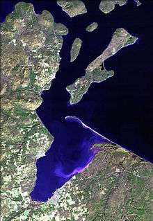 | |
|---|---|---|
| Related Geographic Aspects | ||
| Local Native American Tribes | ||
Municipalities and communities of Ashland County, Wisconsin, United States | ||
|---|---|---|
| Cities | 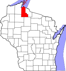 | |
| Village | ||
| Towns | ||
| CDPs | ||
| Unincorporated communities | ||
| Indian reservation | ||
| Footnotes | ‡This populated place also has portions in an adjacent county or counties | |
Municipalities and communities of Bayfield County, Wisconsin, United States | ||
|---|---|---|
| Cities | 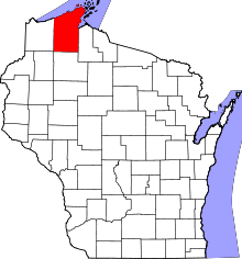 | |
| Village | ||
| Towns | ||
| CDPs | ||
| Unincorporated communities | ||
| Indian reservation | ||
| Footnotes | ‡This populated place also has portions in an adjacent county or counties | |