Juneau County, Wisconsin
| Juneau County, Wisconsin | |
|---|---|
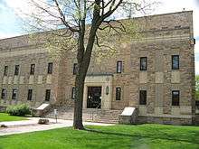 Juneau County Courthouse | |
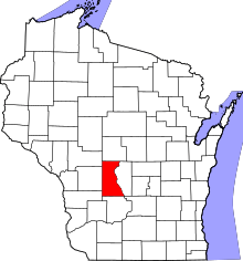 Location in the U.S. state of Wisconsin | |
 Wisconsin's location in the U.S. | |
| 43°55′N 90°07′W / 43.92°N 90.11°WCoordinates: 43°55′N 90°07′W / 43.92°N 90.11°W | |
| Founded | 1857 |
| Seat | Mauston |
| Largest city | Mauston |
| Area | |
| • Total | 804 sq mi (2,082 km2) |
| • Land | 767 sq mi (1,987 km2) |
| • Water | 37 sq mi (96 km2), 4.6% |
| Population | |
| • (2010) | 26,664 |
| • Density | 35/sq mi (14/km2) |
| Congressional districts | 3rd, 7th |
| Time zone | Central: UTC−6/−5 |
| Website |
www |
Juneau County is a county located in the U.S. state of Wisconsin. As of the 2010 census, the population was 26,664.[1] Its county seat is Mauston.[2]
History
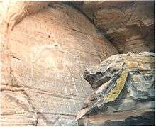
Before white settlement, before loggers and explorers, the area that is now Juneau County was the home of Native Americans who left behind artifacts like the thunderbirds etched on the wall at Twin Bluffs[3] and the Gee's Slough mounds outside New Lisbon.[4]
Juneau County was established in 1857 when the State of Wisconsin passed legislation separating lands west of the Wisconsin River from what was then Adams County.[5] After a contest with neighboring New Lisbon, the county seat was established in Maugh's Town, which is known today as Mauston. The county was named after Solomon Juneau, a founder of Milwaukee.[6]
Geography
According to the U.S. Census Bureau, the county has a total area of 804 square miles (2,080 km2), of which 767 square miles (1,990 km2) is land and 37 square miles (96 km2) (4.6%) is water.[7]
Major highways
Airports
- Necedah Airport (KDAF), serves the county and surrounding communities.
- Mauston–New Lisbon Union Airport (82C) enhances county service.
Adjacent counties
- Wood County - north
- Adams County - east
- Columbia County - southeast
- Sauk County - south
- Vernon County - southwest
- Monroe County - west
- Jackson County - northwest
National protected area
United States Military Posts
Demographics
| Historical population | |||
|---|---|---|---|
| Census | Pop. | %± | |
| 1860 | 8,770 | — | |
| 1870 | 12,372 | 41.1% | |
| 1880 | 15,582 | 25.9% | |
| 1890 | 17,121 | 9.9% | |
| 1900 | 20,629 | 20.5% | |
| 1910 | 19,569 | −5.1% | |
| 1920 | 19,209 | −1.8% | |
| 1930 | 17,264 | −10.1% | |
| 1940 | 18,708 | 8.4% | |
| 1950 | 18,930 | 1.2% | |
| 1960 | 17,490 | −7.6% | |
| 1970 | 18,455 | 5.5% | |
| 1980 | 21,039 | 14.0% | |
| 1990 | 21,650 | 2.9% | |
| 2000 | 24,316 | 12.3% | |
| 2010 | 26,664 | 9.7% | |
| Est. 2016 | 26,274 | [8] | −1.5% |
| U.S. Decennial Census[9] 1790–1960[10] 1900–1990[11] 1990–2000[12] 2010–2014[1] | |||
As of the census[13] of 2000, there were 24,316 people, 9,696 households, and 6,699 families residing in the county. The population density was 32 people per square mile (12/km²). There were 12,370 housing units at an average density of 16 per square mile (6/km²). The racial makeup of the county was 96.61% White, 0.33% Black or African American, 1.30% Native American, 0.44% Asian, 0.02% Pacific Islander, 0.57% from other races, and 0.74% from two or more races. 1.43% of the population were Hispanic or Latino of any race. 41.2% were of German, 9.9% Irish, 8.8% Norwegian, 6.5% Polish and 5.8% English ancestry according to Census 2000.
There were 9,696 households out of which 30.4% had children under the age of 18 living with them, 55.5% were married couples living together, 8.8% had a female householder with no husband present, and 30.9% were non-families. 26.0% of all households were made up of individuals and 12.30% had someone living alone who was 65 years of age or older. The average household size was 2.47 and the average family size was 2.96.
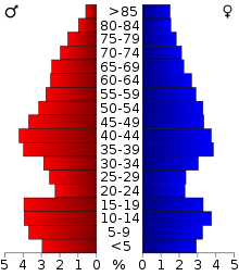
In the county, the population was spread out with 25.4% under the age of 18, 6.9% from 18 to 24, 26.6% from 25 to 44, 24.3% from 45 to 64, and 16.8% who were 65 years of age or older. The median age was 39 years. For every 100 females there were 100.1 males. For every 100 females age 18 and over, there were 97.4 males.
Communities

Cities
- Elroy
- Mauston (county seat)
- New Lisbon
- Wisconsin Dells (mostly in Columbia County, Adams County, and Sauk County)
Villages
Towns
Unincorporated communities
Politics
| Year | Republican | Democratic | Third parties |
|---|---|---|---|
| 2016 | 60.8% 7,130 | 34.7% 4,073 | 4.5% 532 |
| 2012 | 45.8% 5,411 | 52.8% 6,242 | 1.5% 174 |
| 2008 | 44.7% 5,148 | 53.7% 6,186 | 1.7% 196 |
| 2004 | 52.3% 6,473 | 46.3% 5,734 | 1.4% 172 |
| 2000 | 48.1% 4,910 | 47.1% 4,813 | 4.9% 495 |
| 1996 | 35.1% 3,226 | 47.2% 4,331 | 17.7% 1,625 |
| 1992 | 36.9% 4,051 | 38.0% 4,177 | 25.2% 2,765 |
| 1988 | 56.2% 4,869 | 43.1% 3,734 | 0.7% 59 |
| 1984 | 63.6% 5,629 | 35.6% 3,152 | 0.8% 67 |
| 1980 | 55.1% 5,591 | 38.3% 3,884 | 6.6% 665 |
| 1976 | 46.7% 4,242 | 49.7% 4,512 | 3.6% 323 |
| 1972 | 60.2% 4,833 | 36.7% 2,943 | 3.2% 254 |
| 1968 | 53.6% 3,828 | 36.3% 2,595 | 10.1% 719 |
| 1964 | 39.3% 2,976 | 60.6% 4,583 | 0.1% 8 |
| 1960 | 60.6% 4,997 | 39.3% 3,238 | 0.1% 11 |
| 1956 | 67.6% 5,135 | 32.0% 2,428 | 0.5% 35 |
| 1952 | 73.2% 5,978 | 26.5% 2,163 | 0.3% 23 |
| 1948 | 55.7% 3,793 | 42.4% 2,889 | 1.9% 127 |
| 1944 | 62.0% 4,733 | 37.4% 2,857 | 0.6% 47 |
| 1940 | 60.5% 5,268 | 38.5% 3,354 | 1.0% 84 |
| 1936 | 37.8% 3,084 | 55.7% 4,544 | 6.4% 524 |
| 1932 | 29.4% 2,018 | 68.8% 4,723 | 1.9% 129 |
| 1928 | 57.7% 3,777 | 41.4% 2,708 | 0.9% 56 |
| 1924 | 31.1% 1,917 | 6.5% 403 | 62.4% 3,844 |
| 1920 | 81.2% 4,385 | 14.3% 774 | 4.5% 240 |
| 1916 | 58.7% 2,292 | 36.9% 1,442 | 4.5% 174 |
| 1912 | 41.5% 1,322 | 38.8% 1,236 | 19.7% 629 |
| 1908 | 57.6% 2,454 | 39.7% 1,691 | 2.7% 116 |
| 1904 | 70.1% 3,234 | 27.0% 1,244 | 2.9% 135 |
| 1900 | 63.4% 2,914 | 34.5% 1,586 | 2.2% 100 |
| 1896 | 61.5% 2,832 | 36.3% 1,671 | 2.2% 103 |
| 1892 | 47.1% 1,945 | 47.9% 1,978 | 5.0% 206 |
Juneau County can be considered a bellwether in Presidential Elections. The county has a perfect record of being won by the winning candidate in every Presidential Election since 1964.
See also
References
- 1 2 "State & County QuickFacts". United States Census Bureau. Archived from the original on July 12, 2011. Retrieved January 21, 2014.
- ↑ "Find a County". National Association of Counties. Archived from the original on 2011-05-31. Retrieved 2011-06-07.
- ↑ "Twin Bluff". Mississippi Valley Archaeology Center. Retrieved 2017-11-20.
- ↑ Birmingham, Robert A.; Leslie E. Eisenberg (2000). Indian Mounds of Wisconsin. Madison, Wisc.: University of Wisconsin Press. p. 204. ISBN 9780299168742.
- ↑ Wisconsin Acts. 1856. Ch. 130 Approved 13 October 1856. Went into effect 1 January 1857.
- ↑ Juneau County - Home Retrieved 25 February 2015.
- ↑ "2010 Census Gazetteer Files". United States Census Bureau. August 22, 2012. Retrieved August 5, 2015.
- ↑ "Population and Housing Unit Estimates". Retrieved June 9, 2017.
- ↑ "U.S. Decennial Census". United States Census Bureau. Archived from the original on May 12, 2015. Retrieved August 5, 2015.
- ↑ "Historical Census Browser". University of Virginia Library. Retrieved August 5, 2015.
- ↑ Forstall, Richard L., ed. (March 27, 1995). "Population of Counties by Decennial Census: 1900 to 1990". United States Census Bureau. Retrieved August 5, 2015.
- ↑ "Census 2000 PHC-T-4. Ranking Tables for Counties: 1990 and 2000" (PDF). United States Census Bureau. April 2, 2001. Retrieved August 5, 2015.
- ↑ "American FactFinder". United States Census Bureau. Retrieved 2011-05-14.
- ↑ Leip, David. "Dave Leip's Atlas of U.S. Presidential Elections". uselectionatlas.org. Retrieved 2018-08-13.
Further reading
- Biographical History of La Crosse, Monroe and Juneau Counties, Wisconsin. Chicago: Lewis Publishing Company, 1892.
External links
- Juneau County government website
- Juneau County map from the Wisconsin Department of Transportation
- Juneau County Economic Development website
- Juneau County Health and Demographic Data
- Wisconsin Hometown Stories: Juneau County Documentary produced by Wisconsin Public Television
Places adjacent to Juneau County, Wisconsin | ||||||||||
|---|---|---|---|---|---|---|---|---|---|---|
| ||||||||||
Municipalities and communities of Juneau County, Wisconsin, United States | ||
|---|---|---|
| Cities | | |
| Villages | ||
| Towns | ||
| Unincorporated communities | ||
| Indian reservation | ||
| Footnotes | ‡This populated place also has portions in an adjacent county or counties | |

| Authority control |
|---|