Fond du Lac County, Wisconsin
| Fond du Lac County, Wisconsin | |
|---|---|
 Lighthouse at Lake Winnebago, in Fond du Lac. | |
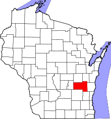 Location in the U.S. state of Wisconsin | |
 Wisconsin's location in the U.S. | |
| Founded | 1839[1] |
| Seat | Fond du Lac |
| Largest city | Fond du Lac |
| Area | |
| • Total | 766 sq mi (1,984 km2) |
| • Land | 720 sq mi (1,865 km2) |
| • Water | 46 sq mi (119 km2), 6.0% |
| Population | |
| • (2010) | 101,633 |
| • Density | 141/sq mi (54/km2) |
| Congressional district | 6th |
| Time zone | Central: UTC−6/−5 |
| Website |
www |
Fond du Lac County is a county in the U.S. state of Wisconsin. As of the 2010 census, the population was 101,633.[2] Its county seat is Fond du Lac.[3] The county was created in the Wisconsin Territory in 1836 and later organized in 1844.[4] Fond du Lac is French for "bottom of the lake", so given because of the county's location at the southern shore of Lake Winnebago.[5][6][7]
Fond du Lac County comprises the Fond du Lac, Wisconsin Metropolitan Statistical Area.[8]
The Holyland region is in northeastern Fond du Lac County.
Geography
According to the U.S. Census Bureau, the county has a total area of 766 square miles (1,980 km2), of which 720 square miles (1,900 km2) is land and 46 square miles (120 km2) (6.0%) is water.[9]
Major highways
Airport
Fond du Lac County Airport (IATA: FLD, ICAO: KFLD, FAA LID: FLD) serves the county and surrounding communities.
Adjacent counties
- Winnebago County – north
- Calumet County – northeast
- Sheboygan County – east
- Washington County – southeast
- Dodge County – southwest
- Green Lake County – west
National protected area
Demographics
| Historical population | |||
|---|---|---|---|
| Census | Pop. | %± | |
| 1840 | 139 | — | |
| 1850 | 14,510 | 10,338.8% | |
| 1860 | 34,154 | 135.4% | |
| 1870 | 46,273 | 35.5% | |
| 1880 | 46,859 | 1.3% | |
| 1890 | 44,088 | −5.9% | |
| 1900 | 47,589 | 7.9% | |
| 1910 | 51,610 | 8.4% | |
| 1920 | 56,119 | 8.7% | |
| 1930 | 59,883 | 6.7% | |
| 1940 | 62,353 | 4.1% | |
| 1950 | 67,829 | 8.8% | |
| 1960 | 75,085 | 10.7% | |
| 1970 | 84,567 | 12.6% | |
| 1980 | 88,964 | 5.2% | |
| 1990 | 90,083 | 1.3% | |
| 2000 | 97,296 | 8.0% | |
| 2010 | 101,633 | 4.5% | |
| Est. 2016 | 102,144 | [10] | 0.5% |
| U.S. Decennial Census[11] 1790–1960[12] 1900–1990[13] 1990–2000[14] 2010–2014[2] | |||
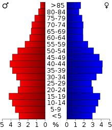
As of the census[15] of 2000, there were 97,296 people, 36,931 households, and 25,482 families residing in the county. The population density was 135 people per square mile (52/km²). There were 39,271 housing units at an average density of 54 per square mile (21/km²). The racial makeup of the county was 96.16% White, 0.90% Black or African American, 0.38% Native American, 0.87% Asian, 0.03% Pacific Islander, 0.84% from other races, and 0.82% from two or more races. 2.04% of the population were Hispanic or Latino of any race. 57.7% were of German, 6.1% Irish and 5.3% American ancestry according to Census 2000. 95.5% spoke English, 2.1% Spanish and 1.3% German as their first language.
There were 36,931 households out of which 32.80% had children under the age of 18 living with them, 57.70% were married couples living together, 7.80% had a female householder with no husband present, and 31.00% were non-families. 25.40% of all households were made up of individuals and 10.80% had someone living alone who was 65 years of age or older. The average household size was 2.52 and the average family size was 3.04.
In the county, the population was spread out with 25.20% under the age of 18, 9.40% from 18 to 24, 28.70% from 25 to 44, 22.40% from 45 to 64, and 14.30% who were 65 years of age or older. The median age was 37 years. For every 100 females there were 95.30 males. For every 100 females age 18 and over, there were 92.20 males.
Communities
Cities
- Fond du Lac (county seat)
- Ripon
- Waupun (mostly in Dodge County)
Villages
Towns
Census-designated places
Unincorporated communities

- Alto
- Ashford
- Arcade Acres
- Armstrong
- Artesia Beach
- Banner
- Bergen Beach
- Byron
- Calumet Harbor
- Calumetville
- Calvary
- Chinatown
- Dexter
- Dotyville
- Dundee
- Eldorado
- Elmore
- Garnet
- Gladstone Beach
- Graham Corners
- Hamilton
- Highland Park
- Hopokoekau Beach
- Johnsburg
- Ladoga
- Laudolff Beach
- Luco
- Malone
- Marblehead
- Marytown
- Metomen
- Minawa Beach
- New Fane
- New Prospect
- Oak Center
- Peebles
- Pipe
- Pukwana Beach
- Rogersville
- Rosendale Center
- St. Joe
- Silica
- South Byron
- Waucousta
- Welling Beach
- West Rosendale
- Wilmoore Heights
- Winnebago Heights
- Winnebago Park
- Woodhull
Ghost towns/neighborhoods
Politics
| Year | Republican | Democratic | Third parties |
|---|---|---|---|
| 2016 | 59.9% 31,022 | 33.6% 17,387 | 6.5% 3,387 |
| 2012 | 56.8% 30,355 | 41.9% 22,379 | 1.3% 668 |
| 2008 | 53.8% 28,164 | 44.8% 23,463 | 1.3% 696 |
| 2004 | 62.8% 33,291 | 36.2% 19,216 | 1.0% 529 |
| 2000 | 57.0% 26,548 | 39.0% 18,181 | 4.0% 1,860 |
| 1996 | 44.7% 16,488 | 42.1% 15,542 | 13.3% 4,901 |
| 1992 | 44.5% 19,785 | 30.9% 13,757 | 24.6% 10,964 |
| 1988 | 57.6% 21,985 | 41.6% 15,887 | 0.8% 303 |
| 1984 | 64.6% 26,069 | 34.7% 13,983 | 0.7% 294 |
| 1980 | 57.0% 24,196 | 36.0% 15,293 | 7.0% 2,981 |
| 1976 | 55.8% 22,226 | 41.6% 16,571 | 2.6% 1,044 |
| 1972 | 61.0% 21,007 | 35.0% 12,050 | 4.0% 1,386 |
| 1968 | 55.6% 18,184 | 38.4% 12,563 | 6.0% 1,962 |
| 1964 | 41.3% 12,708 | 58.6% 18,040 | 0.1% 30 |
| 1960 | 59.7% 19,498 | 40.2% 13,132 | 0.2% 58 |
| 1956 | 72.5% 21,496 | 26.8% 7,940 | 0.8% 230 |
| 1952 | 74.4% 22,794 | 25.2% 7,724 | 0.4% 107 |
| 1948 | 59.6% 13,760 | 38.6% 8,904 | 1.8% 419 |
| 1944 | 63.8% 16,785 | 35.7% 9,378 | 0.5% 143 |
| 1940 | 61.5% 16,804 | 37.8% 10,323 | 0.8% 215 |
| 1936 | 35.4% 9,179 | 57.2% 14,821 | 7.5% 1,931 |
| 1932 | 33.7% 8,436 | 64.6% 16,143 | 1.7% 425 |
| 1928 | 51.4% 12,593 | 47.8% 11,719 | 0.8% 205 |
| 1924 | 41.6% 8,516 | 10.9% 2,222 | 47.5% 9,722 |
| 1920 | 74.6% 12,543 | 20.3% 3,409 | 5.2% 867 |
| 1916 | 52.2% 5,781 | 45.3% 5,021 | 2.5% 282 |
| 1912 | 31.3% 3,014 | 50.3% 4,838 | 18.3% 1,764 |
| 1908 | 50.9% 5,872 | 45.0% 5,194 | 4.2% 479 |
| 1904 | 59.6% 7,027 | 37.5% 4,417 | 3.0% 350 |
| 1900 | 53.8% 6,258 | 44.2% 5,140 | 2.0% 230 |
| 1896 | 54.2% 6,174 | 43.3% 4,933 | 2.6% 294 |
| 1892 | 42.5% 4,129 | 54.0% 5,254 | 3.5% 339 |
See also
References
- ↑ "County Facts - Fond du Lac County". www.fdlco.wi.gov. Retrieved 7 May 2018.
- 1 2 "State & County QuickFacts". United States Census Bureau. Archived from the original on July 10, 2011. Retrieved January 18, 2014.
- ↑ "Find a County". National Association of Counties. Archived from the original on 2011-05-31. Retrieved 2011-06-07.
- ↑ "Wisconsin: Individual County Chronologies". Wisconsin Atlas of Historical County Boundaries. The Newberry Library. 2007. Retrieved August 13, 2015.
- ↑ "Dictionary of Wisconsin History". Wisconsin Historical Society. Retrieved 2008-10-20.
- ↑ Clorissa Swingen (Spring 1988). "Fond du Lac: Links to our Past". Retrieved 2007-03-20.
- ↑ Gannett, Henry (1905). The Origin of Certain Place Names in the United States. Govt. Print. Off. p. 128.
- ↑ "Metropolitan Statistical Areas of Wisconsin's 2014 Winter Report on Wisconsin Department of Revenue Division of Research & Policy" (PDF).
- ↑ "2010 Census Gazetteer Files". United States Census Bureau. August 22, 2012. Retrieved August 4, 2015.
- ↑ "Population and Housing Unit Estimates". Retrieved June 9, 2017.
- ↑ "U.S. Decennial Census". United States Census Bureau. Archived from the original on May 12, 2015. Retrieved August 4, 2015.
- ↑ "Historical Census Browser". University of Virginia Library. Retrieved August 4, 2015.
- ↑ Forstall, Richard L., ed. (March 27, 1995). "Population of Counties by Decennial Census: 1900 to 1990". United States Census Bureau. Retrieved August 4, 2015.
- ↑ "Census 2000 PHC-T-4. Ranking Tables for Counties: 1990 and 2000" (PDF). United States Census Bureau. April 2, 2001. Retrieved August 4, 2015.
- ↑ "American FactFinder". United States Census Bureau. Archived from the original on 2013-09-11. Retrieved 2011-05-14.
- ↑ Leip, David. "Dave Leip's Atlas of U.S. Presidential Elections". uselectionatlas.org. Retrieved 2018-05-07.
Further reading
- Glaze, A. T. Incidents and Anecdotes of Early Days and History of Business in the City and County of Fond du Lac From Early Times to the Present. Fond du Lac: P. B. Haber, 1905.
- McKenna, Maurice (ed.). Fond du Lac County Wisconsin, Past and Present. Chicago: S. J. Clarke, 1912.
External links
- Fond du Lac County website
- Fond du Lac County map from the Wisconsin Department of Transportation
Places adjacent to Fond du Lac County, Wisconsin | ||||||||||
|---|---|---|---|---|---|---|---|---|---|---|
| ||||||||||
Municipalities and communities of Fond du Lac County, Wisconsin, United States | ||
|---|---|---|
| Cities | | |
| Villages | ||
| Towns | ||
| CDPs | ||
| Unincorporated communities |
| |
| Ghost towns/neighborhoods | ||
| Footnotes | ‡This populated place also has portions in an adjacent county or counties | |
